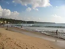
Dreamland Beach, now officially known as New Kuta Beach, is a beach located in Pecatu on the Bukit Peninsula on the island of Bali, Indonesia. A popular surfing beach, it was formerly secluded and had casual refreshment stands and inns. It has since become the beach of an extensive tourist development.
The beach, called Cimongka by the Balinese, was named Dreamland Beach by Australians. It was popular with surfers and also with nudists, and became the most popular beach in Pecatu. Starting in the 1980s, warungs (refreshment shacks) and cheap inns were built at the beach.[1][2]
PT Bali Pecatu Graha, a company owned by Tommy Suharto, the youngest son of former Indonesian president Suharto, bought land including the beach in 1995 and the following year began development of the 400-hectare Pecatu Indah Resort; the beach was renamed New Kuta Beach and the resort eventually also became New Kuta Beach.[1][3] Development was paused from 1998 to 2004 because of the Asian financial crisis and the 2002 Bali bombings;[3] in the late 2000s, approximately 38 businesses were relocated from the beach to purpose-built shops.[1][2]
Uluwatu Temple
Uluwatu Temple is about 12 km from the Dreamland beach location. The temple has a very beautiful interior and exterior, so you won’t regret it when you visit it when you are in bali.[5]
See also
References
- 1 2 3 Tim Hannigan (2007-08-02). "Dreamland to Be Renamed 'New Kuta Beach' as Pecatu Area to Get Resort". The Bali Times. Retrieved 2021-09-11.
- 1 2 Claudia Sardi (2009-02-10). "Big project erases 'dream' from Dreamland". The Jakarta Post. Retrieved 2021-09-11.
- 1 2 3 "New Kuta Beach The Ultimate Resort". Jalanasik. 2009-07-04. Archived from the original on 2011-02-28.
- ↑ Vath. "Dreamland Beach the steep rock walls for enjoying the sunset". Amazing Tourism Traveling. Archived from the original on 2012-03-21.
- ↑ "Dreamland Beach Bali - Fee, Maps, Route, Hotels, Thing to Do". BaliIndonesiaHolidays.com. 2022-04-30. Retrieved 2022-05-10.
External links
![]() Bukit Peninsula travel guide from Wikivoyage
Bukit Peninsula travel guide from Wikivoyage