Družec | |
|---|---|
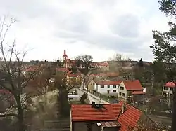
 Družec from the Calvary Rock | |
 Flag  Coat of arms | |
 Družec Location in the Czech Republic | |
| Coordinates: 50°6′11″N 14°2′44″E / 50.10306°N 14.04556°E | |
| Country | |
| Region | Central Bohemian |
| District | Kladno |
| First mentioned | 1320 |
| Area | |
| • Total | 7.12 km2 (2.75 sq mi) |
| Elevation | 375 m (1,230 ft) |
| Population (2023-01-01)[1] | |
| • Total | 1,072 |
| • Density | 150/km2 (390/sq mi) |
| Time zone | UTC+1 (CET) |
| • Summer (DST) | UTC+2 (CEST) |
| Postal code | 273 62 |
| Website | www |
Družec is a municipality and village in Kladno District in the Central Bohemian Region of the Czech Republic. It has about 1,100 inhabitants.
Geography
Družec is located about 6 kilometres (4 mi) southwest of Kladno and 20 km (12 mi) west of Prague. It lies in the Křivoklát Highlands on the Loděnice River .
History
The first written mention of Družec is from 1320.[2]
Transport
The D6 motorway from Prague to Karlovy Vary runs through the northern part of the municipality.
Sights
The pilgrimage Church of the Assumption of the Virgin Mary was first mentioned in 1352. The originally Gothic church was rebuilt in the Baroque style in 1688–1689.[3]
Next to the church there is a sandstone Marian column from 1674 and a man-sized menhir called Zkamenělec ("Man-turned-into-stone"), surrounded with legends of a punished perjurer.[4]
Gallery
 Church of the Assumption
 Marian column from 1674 next to the church
 Zkamenělec Stone
 Calvary of Družec
References
- ↑ "Population of Municipalities – 1 January 2023". Czech Statistical Office. 2023-05-23.
- ↑ "Družecký vánoční zpravodaj" (in Czech). Obec Družec. December 2019. p. 1. Retrieved 2022-05-18.
- ↑ "V Družci na Kladensku instalovali na kostel novou kopuli" (in Czech). iDnes. 2019-03-27. Retrieved 2022-05-18.
- ↑ "Družec: Křivopřísežník v kámen obrácen!" (in Czech). Czech Radio. 2015-04-25. Retrieved 2022-05-18.
External links
- Official website (in Czech)