Hostouň | |
|---|---|
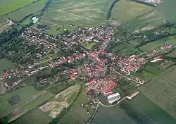
 Aerial view | |
 Flag  Coat of arms | |
 Hostouň Location in the Czech Republic | |
| Coordinates: 50°6′52″N 14°12′5″E / 50.11444°N 14.20139°E | |
| Country | |
| Region | Central Bohemian |
| District | Kladno |
| First mentioned | 1294 |
| Area | |
| • Total | 10.34 km2 (3.99 sq mi) |
| Elevation | 341 m (1,119 ft) |
| Population (2023-01-01)[1] | |
| • Total | 1,509 |
| • Density | 150/km2 (380/sq mi) |
| Time zone | UTC+1 (CET) |
| • Summer (DST) | UTC+2 (CEST) |
| Postal code | 273 53 |
| Website | www |
Hostouň (Czech pronunciation: [ˈɦostouɲ]) is a municipality and village in Kladno District in the Central Bohemian Region of the Czech Republic. It has about 1,500 inhabitants.
Geography
Hostouň is located about 6 kilometres (4 mi) southeast of Kladno and 9 km (6 mi) west of Prague. It lies in a flat agricultural landscape in the Prague Plateau.
History
The first written mention of Hostouň is from 1294. There was a fortress called Šafránov. It used to be a wealthy village with a significant Jewish community.[2]
Transport
The D6 motorway from Prague to Karlovy Vary passes through the municipality.
Sport
The municipality is home to the football club Sokol Hostouň, which plays in the Bohemian Football League (3rd tier of the Czech football league system).
Sights
The main landmark of Hostouň is the Church of Saint Bartholomew. It was originally a medieval Gothic church, first mentioned in 1352. It was rebuilt in the Baroque style and extended at the beginning of the 18th century. The tower was added in 1773.[3]
In the municipality are two Jewish cemeteries. The Old Cemetery was founded in the 16th century and the New Cemetery was founded in the first half of the 18th century.[2]
References
- ↑ "Population of Municipalities – 1 January 2023". Czech Statistical Office. 2023-05-23.
- 1 2 "Historie" (in Czech). Obec Hostouň. Retrieved 2023-04-05.
- ↑ "Kostel sv. Bartoloměje" (in Czech). National Heritage Institute. Retrieved 2023-04-05.