Duki District
ضلع دوکی دوکي ولسوالۍ دوکی دمگ | |
|---|---|
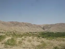
 Hairan Haiderzai Mound | |
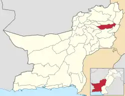
 Map of Balochistan with Duki District highlighted | |
| Country | |
| Province | |
| Division | Loralai |
| Established | 2016 |
| Headquarters | Duki |
| Government | |
| • Type | District Administration |
| • Deputy Commissioner | N/A |
| • District Police Officer | N/A |
| • District Health Officer | N/A |
| Area | |
| • Total | 4,233 km2 (1,634 sq mi) |
| Population (2017) | |
| • Total | 152,977 |
| • Density | 36/km2 (94/sq mi) |
| Time zone | UTC+5 (PKT) |
Duki (Urdu: ضلع دوکی) is a district in the Balochistan province of Pakistan.[1] It is located at an altitude of 1092 metres (3585 feet).[2] It is sub-divided into union councils, mainly Vialla Duki, Zangal Rabat, Sadar, Civil Station, Nasarbad, Thal-Chotiali, Luni and Nana Sahib Ziarat. Its main revenue comes from agriculture and natural resources. Being a tribal society it has tribes: Tareens including Raisani, Kakars (Shadozai), Lunis, Zarkoon & Nasar etc. Duki is one of Pakistan's least developed districts, lagging behind in development, health, education, infrastructure and many other facilities. It is the only district where two polio cases were reported in 2018. Duki was made a district in 2016 and its sub-divisions are Thal-Chotiali, Nana Sahib Ziarat, and Luni.
Duki was part of Loralai District until 2017. In 2017 Duki was declared as a separate district itself. There are total 19 union councils. District Government consisted of Deputy commissioner, Assistant Commissioner, DPO, Tehsildar. Moreover, after local bodies election Chairman District council and municipal committee also contributes in delivery of public services in the district.
Demographics
At the time of the 2017 census the district had 21,345 households and a population of 152,977, of which 10,042 (6.56%) lived in urban areas. Duki district had a sex ratio of 865 females per 1000 males and a literacy rate was 28.65% - 40.68% for males and 14.58% for females. 56,255 (36.77%) were under 10 years of age. 206 (0.13%) people in the district were from religious minorities.[3]
At the time of the 2017 census, 85.86% of the population spoke Pashto, 6.41% Balochi, 2.86% Brahui and 1.06% Saraiki as their first language.[3]
Education
The literacy rate is 30% of the population and the same is due to the private Educational Institution Especially Nizami School and some others while female literacy rate is below 10% and here the same is due to the Religious Centres i.e. Madrasas Especially Jamia Nizamiyah LilBanat and others.
Revenue record reveals that Duki is the only subdivision in entire Zhob Division that is a settled area. Duki is also the hottest place in the entire administrative division, and is a major coal deposit.
References
- ↑ Tehsils & Unions in the District of Loralai - Government Archived March 26, 2012, at the Wayback Machine
- ↑ Location of Duki - Falling Rain Genomics
- 1 2 "District-wise census tables". www.pbscensus.gov.pk. Pakistan Bureau of Statistics.
30°9′0″N 68°34′0″E / 30.15000°N 68.56667°E
