Dunkeld | |
|---|---|
 | |
 Dunkeld  Dunkeld | |
| Coordinates: 26°8′10″S 28°2′21″E / 26.13611°S 28.03917°E / -26.13611; 28.03917 | |
| Country | South Africa |
| Province | Gauteng |
| Municipality | City of Johannesburg |
| Main Place | Randburg |
| Area | |
| • Total | 1.38 km2 (0.53 sq mi) |
| Population (2011)[1] | |
| • Total | 1,473 |
| • Density | 1,100/km2 (2,800/sq mi) |
| Racial makeup (2011) | |
| • Black African | 28.6% |
| • Coloured | 1.8% |
| • Indian/Asian | 2.9% |
| • White | 64.4% |
| • Other | 2.4% |
| First languages (2011) | |
| • English | 65.1% |
| • Afrikaans | 11.3% |
| • Zulu | 5.4% |
| • Northern Sotho | 2.8% |
| • Other | 15.4% |
| Time zone | UTC+2 (SAST) |
| Postal code (street) | 2196 |
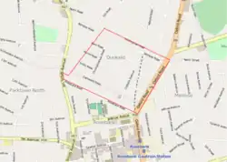
Dunkeld is a suburb of Johannesburg, South Africa. It is located in Region 3. It is bordered by the suburbs of Hyde Park and Illovo to the north, Melrose to the east, Rosebank in the south and to the west, Dunkeld West.
Origin of the name
The Dunkeld suburbs name has it origin in a small town in Perth and Kinross, Scotland.[2] The township was laid out in 1904.[3]: 163 The main street through the suburb, Bompass Street, is named after accountant and real estate pioneer Frank W.R. Bompass. [3]: 170
References
- 1 2 3 4 "Sub Place Dunkeld". Census 2011.
- ↑ Kendall, Ian (October 2009). "Scottish Place Names - Johannesburg, South Africa". Ian Kendall. Retrieved 17 April 2016.
- 1 2 Leyds, Gerald Anton (1964). A History of Johannesburg: The Early Years. Nasional Boekhandel. p. 318.
External links
- Scottish Place Names in Johannesburg, South Africa lists suburbs with Scottish placenames.
This article is issued from Wikipedia. The text is licensed under Creative Commons - Attribution - Sharealike. Additional terms may apply for the media files.