| Emigrant Peak | |
|---|---|
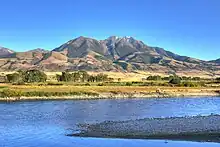
 Emigrant Peak from East River Road, 2009 | |
| Highest point | |
| Elevation | 10,926 ft (3,330 m)[1] NAVD 88 |
| Prominence | 2609[1] |
| Coordinates | 45°15′47″N 110°42′26″W / 45.26306°N 110.70722°W[2] |
| Geography | |
 Emigrant Peak | |
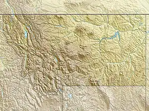
| Parent range | Absaroka Range |
| Topo map | USGS Emigrant, MT |
| Climbing | |
| First ascent | Unknown |
| Easiest route | Hike |
Emigrant Peak el. 10,926 feet (3,330 m) is a prominent mountain peak on the western edge of the Absaroka Range near Emigrant, Montana.[3] The peak is flanked by Emigrant Gulch on the north and Sixmile Creek on the south with the Gallatin National Forest and lies just outside the Absaroka-Beartooth Wilderness. The peak is readily visible from Paradise Valley, Montana and U.S. Route 89 when traveling to the north entrance of Yellowstone National Park at Gardiner, Montana.
Emigrant Peak
Notes
- 1 2 "Emigrant Peak, Montana". Peakbagger.com. Retrieved June 7, 2018.
- ↑ "Emigrant Peak". Geographic Names Information System. United States Geological Survey, United States Department of the Interior. Retrieved June 7, 2018.
- ↑ Emigrant, MT (Map). TopoQwest (United States Geological Survey Maps). Retrieved June 7, 2018.

Emigrant Peak, Paradise Valley
Wikimedia Commons has media related to Emigrant Peak.
This article is issued from Wikipedia. The text is licensed under Creative Commons - Attribution - Sharealike. Additional terms may apply for the media files.