 | ||||
|---|---|---|---|---|
| Автошлях М19 | ||||
 | ||||
| Route information | ||||
| Part of | ||||
| Length | 503.9 km (313.1 mi) | |||
| Major junctions | ||||
| North end | ||||
| South end | ||||
| Location | ||||
| Country | Ukraine | |||
| Oblasts | Volyn, Rivne, Ternopil, Chernivtsi | |||
| Highway system | ||||
| ||||
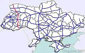
Highway M19 is a Ukrainian international highway (M-highway) that completely corresponds to whole length of European route E85 that runs through Ukraine.
Crossing Western Ukraine from north to south, it connects the historical region Volhynia (border with Belarus) with Southern Bukovina (border of Romania).[1][2]
Main route
Main route and connections to/intersections with other highways in Ukraine.
| Marker | Main settlements | Highway Interchanges |
|---|---|---|
| 0 km | Domanove / Border |
|
| Kovel | ||
| Lutsk | ||
| Dubno | ||
| Ternopil | ||
| Chernivtsi | ||
| 504 km | Porubne / Border |
Gallery
 Highway M19 near Lutsk
 M19 in Volyn Oblast
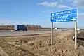 M19 road near Zbarazh
 An old viaduct near the highway
See also
References
External links
- International Roads in Ukraine in Russian
- European Roads in Russian
| E-roads in Ukraine | ||
|---|---|---|
| International | ||
| National | ||
| Regional | ||
| ||
This article is issued from Wikipedia. The text is licensed under Creative Commons - Attribution - Sharealike. Additional terms may apply for the media files.