 | |
| Type | Extratropical cyclone Winter storm Nor'easter Blizzard |
|---|---|
| Formed | February 1, 2010 |
| Dissipated | February 11, 2010 |
| Lowest pressure | 978 mb (28.88 inHg) |
| Maximum snowfall or ice accretion | 38.3 inches (97 cm) at Elkridge, Maryland |
| Fatalities | At least 41 fatalities (including at least 28 in Mexico and 13 in the US) |
| Areas affected | Midwest and East Coast of the United States (from Illinois to Georgia to Vermont) New Mexico, Mexico, Eastern Canada, California, Arizona |
Part of the 2009–10 North American winter | |
The February 5–6, 2010 North American blizzard, commonly referred to as Snowmageddon,[1] was a blizzard that had major and widespread impact in the Northeastern United States. The storm's center tracked from Baja California Sur on February 2, 2010, to the east coast on February 6, 2010, before heading east out into the Atlantic. Effects were felt to the north and west of this track in northern Mexico, California, and the southwestern, midwestern, southeastern, and most notably Mid-Atlantic states. Severe weather, including extensive flooding and landslides in Mexico, and historic snowfall totals in every one of the Mid-Atlantic states, brought deaths to Mexico, New Mexico, Virginia, Pennsylvania, and Maryland.[2]
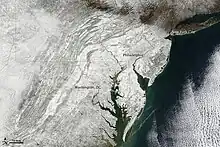
Most crippling was the widespread 20 to 35 in (50 to 90 cm) of snow accumulated across southern Pennsylvania, the Eastern Panhandle of West Virginia, northern Virginia, Washington, D.C., Maryland, Delaware, and South Jersey, bringing air and interstate highway travel to a halt. Rail service south and west of Washington, D.C. was suspended, and rail travel between D.C. and Boston was available with limited service.[3] Blizzard conditions were reported in a relatively small area of Maryland, but near-blizzard conditions occurred across much of the Mid-Atlantic region.[4]
This event was the second of four nor'easters during the 2009–2010 winter that brought heavy snow to enough of the Northeast's population to be numerically recognized by NOAA's NESIS intensity rating. The first and third of these systems, the December 2009 Nor'Easter and the February 9–10, 2010 North American blizzard, respectively, combined with this event to bring the snowiest winter on record to much of the Mid-Atlantic. Additionally, this event was the second of three major Mid-Atlantic snowstorms that occurred over a 12-day period; each subsequent storm focused its heaviest snow slightly farther north: the January 30, 2010, storm (not recognized by NESIS) dropped more than a foot of snow across Virginia and the lower Chesapeake Bay region, while the February 9–10, 2010 North American blizzard bulls-eyed the Maryland-Pennsylvania border with as much as 38.3 inches.[5][6]
Meteorological history
The main storm system originated in the Pacific Ocean, bringing heavy rain and mountain snow to California and Arizona on February 2. The storm center moved east through northern Mexico on February 3. The system produced over one foot of snowfall in the higher elevations and the eastern plains of New Mexico, shutting down major highways including Interstate 40 east of Albuquerque for several hours on February 3. The storm's center then advanced across Texas to the Louisiana Gulf Coast on February 4, while dropping rain and snow in Oklahoma and northern Texas, and severe thunderstorms further south. Meanwhile, a second, more-northern disturbance tracked from the central Rockies to the lower Missouri River Valley, bringing light snow showers to Montana, the Dakotas, parts of Minnesota, Wisconsin, Iowa, and Illinois.
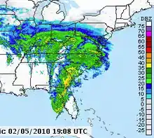
On February 5, the two systems phased together, resulting in a band of heavy snow across Illinois, Indiana, Ohio, and Pennsylvania. That evening, the northern system's energy was absorbed into the main southern circulation, promoting fast intensification. Heavy snow subsequently developed over the Mid-Atlantic states as the storm's center tracked across North Carolina towards the Atlantic Coast.
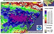
An antecedent and nearly-stationary upper-level ridge over the Maritime Provinces of Canada served to block the storm system from following the traditional northeast track into New England. Instead, during the AM hours of February 6th, the storm center slowed its northeasterly movement as it continued to deepen east of Virginia Beach, before it eventually was forced eastward. The blocking pattern was reflected on the storm's snowfall map by a sharp northern gradient in northern New Jersey and by the axis of heaviest snow running WNW-ESE through Maryland and Delaware (opposed to the SW-NE pattern found from most Nor'Easters). Only moderate accumulations reached the southern suburbs of New York City, with no more than light snow falling in the city itself. Upstate New York and New England were spared from this system, receiving little more than isolated snow flurries in southern sections. Easterly winds and onshore flow contributed to light snow accumulations of less than one inch in Boston, Cape Cod, and parts of coastal Rhode Island.
According to the blog of Weather Channel senior meteorologist Stu Ostro, the storm formed from "Miller Type B" cyclogenesis: a storm centered over the Ohio river runs into a blocking ridge and redevelops along the Carolina coast. (This differed from the North American blizzard of 2009, of "Miller Type A" cyclogenesis where a storm center develops over the eastern Gulf of Mexico and strengthens while tracking north to a latitude of greater temperature contrast.) This storm was carrying an enormous amount of moisture drawn from both the Gulf of Mexico (as seen on February 3 satellite imagery over Mexico), and from the Atlantic (as seen in radar imagery from early on February 5). Ostro characterized the storm as having "strong dynamics" and expected the snowfall to be of long duration, typically leading to large accumulations.[7]
Nicknames
Media reports emphasized the magnitude of the storm, giving rise to many nicknames for it including Snowmageddon[8][9] and Snowpocalypse.[10]
The Capital Weather Gang blog on The Washington Post website ran an online poll on February 4, 2010, asking for reader feedback prior to the blizzard,[11] and several blogs, including the paper's own blog, followed that up by using either "Snowmageddon" and/or "Snowpocalypse" during the following days, before, during, and after the storm hit.[12]
The Washington Post also popularized other portmanteaus, including "snOMG" (from OMG) and "kaisersnoze" (from Keyser Soze), in response to the February snowstorms.[13]
During the evening preceding the first blizzard hitting Washington, D.C., most of the United States federal government closed, and press coverage continued to characterize the storm using either "Snowmageddon", "Snowpocalypse", or both.[14] The phrase was later popularized by the President of the United States, Barack Obama, on February 8, 2010, who used the term while speaking at the Democratic National Committee's meeting.[15]
Snowfall
| State | Greatest Measurement By State | County | Amount (in) |
|---|---|---|---|
| MD | 2 miles WSW of Elkridge | Howard | 38.3 |
| VA | 1 mile ENE of Howellsville | Warren | 37 |
| WV | 2 miles WNW of Lehew | Hampshire | 34 |
| PA | Upper Strasburg | Franklin | 31 |
| NJ | National Park | Gloucester | 28.5 |
| DC | Dalecarlia Reservoir | [Northwest] | 28.0 |
| DE | Wilmington | New Castle | 26.5 |
An unofficial storm total snowfall observation of 39.0" was made from Riverwood, MD (in Frederick County) on CoCoRaHS, and later referenced in the February 2010 Washington Baltimore Climate Review (not published electronically). However NOAA/NWS products list the 38.3" total at 2WSW Elkridge, MD as the "storm's greatest (so far)".
| State | Official Observation Sites | County | Amount (in) |
|---|---|---|---|
| MD | Frostburg | Allegany | 36.0 |
| VA | Washington Dulles International Airport | Loudoun | 32.9 |
| PA | Somerset | Somerset | 30 |
| MD | 2 miles W of Rockville | Montgomery | 29.2 |
| PA | Philadelphia International Airport | Philadelphia | 28.5 |
| VA | Vienna | Fairfax | 26 |
| DE | New Castle Airport | New Castle | 25.8 |
| MD | Baltimore/Washington International Airport | Anne Arundel | 25 |
| NJ | Cape May | Cape May | 21.8 |
| PA | Pittsburgh International Airport | Allegheny | 21.1 |
| NJ | Hammonton | Atlantic | 21 |
| NJ | Atlantic City International Airport | Atlantic | 18.2 |
| PA | Harrisburg International Airport | Dauphin | 18 |
| VA | Ronald Reagan Washington National Airport | Arlington | 17.8 |
| PA | State College | Centre | 14 |
| PA | Lehigh Valley International Airport | Lehigh | 7.7 |
| NY | [Throughout Staten Island] | Richmond | 1–5 |
| NY | Central Park | New York | Trace |
Pittsburgh with 21.1", was the first major city to experience the storm's heavier snowfall, separating sub-20" amounts over Indiana and Ohio from 20 to 35" readings found in the Laurel Highlands and east. This was Pittsburgh's 4th greatest snow event since records began in 1871. Areas south of Pittsburgh received up to 26" of snowfall. Although initially forecast to bring only 4–8" of snow to the area, the storm's track farther to the north lead to the explosive accumulations. The National Weather Service in Pittsburgh office recorded 7" of snow over 700P-1159P February 5 and 5.3" over 300A-600A on February 6.
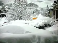
The swath of heaviest snowfall then crossed the Appalachians and squeezed between Washington, D.C., and Baltimore. The District of Columbia's totals were generally near 20", ranging from 18 to 28". Baltimore City's totals were around 25", ranging from 21 to 28". Dulles

International Airport's 32.9" set all-time records (since 1962) for most 2-day and 3-day snowfall, shattering the old records from the Blizzard of 1996 of 23.2" and 24.6", respectively. Dulles received 17.5" on February 6, however, making the day's total only the 3rd greatest 24-hour snowfall amount. Baltimore Washington International Airport, despite being near numerous 30"+ reports, saw a relatively tame 25". This 2-day total was 2nd greatest (since 1892), behind 26.3" from the 1922 Knickerbocker Storm. Reagan National Airport's 17.8" was one of the metro region's lowest, but still ranked as Washington's 4th greatest (since 1871) in both 2-day and 3-day totals.
Additional local reports from Maryland include: Edgemere, 35.4"; Clarksville, 34.9"; Crofton, 34.0"; Columbia, 33.8"; Laurel, 32.9"; Pasadena, 31.0"; Dundalk, 30.5"; Ellicott City, 30.2"; Frederick, 29.0"; Olney, 28.0"; Germantown, 27.4"; and Catonsville, 22.9".
Philadelphia's 28.5" ranked the storm as the city's 2nd greatest on record (since 1872), falling not far behind the Blizzard of 1996's 30.7". This made for Philadelphia's first winter with multiple 20"+ storms, following the 23.2" from the North American blizzard of 2009. Wilmington, DE's 25.8" was their greatest storm total of all-time (since 1894), passing the 1996 storm's 22". In February 2021, the National Centers for Environmental Information announced that the official Delaware snow depth record was established near Greenwood on February 7, 2010, after the February 5–6, 2010 North American blizzard resulted in a measurement of 28 inches. The record was measured at the Greenwood 2.9 SE station of the Community Collaborative Rain, Hail and Snow Network.[16][17]

| State | County/City Averaging > 24" | Range | Greatest Report | (in) |
|---|---|---|---|---|
| VA | Clarke | 31–33" | Berryville | 32 |
| MD | Allegany | 26–36" | Frostburg | 36 |
| MD | Howard | 25–38" | 2 miles WSW of Elkridge | 38.3 |
| VA | Frederick/Winchester | 25–32" | 3 miles WSW of Armel | 31.5 |
| VA | Loudoun | 22–35" | Leesburg | 34 |
| MD | Frederick | 24–34" | Riverwood? | 37–39? |
| MD | Montgomery | 21–34" | West Laurel | 33.5 |
| MD | Baltimore County | 22–32" | Randallstown | 32 |
| VA | Fauquier | 16–33" | Marshall | 32 |
| MD | Anne Arundel | 18–34" | Crofton | 34 |
| MD | Carroll | 22–29" | Eldersburg | 29.1 |
| MD | Baltimore City | 21–28" | Pimlico | 28 |
| MD | Harford | 23–29" | Norrisville | 29 |
| MD | Washington | 22–32" | 3 miles ENE of Hancock | 31.5 |
| VA | Prince William/Manassas | 22–32" | 5 miles NNE of Antioch | 32 |
South Jersey saw as much as 29" of snow; Vineland reported 19.8".[18] In South Central Pennsylvania, the areas of Harrisburg, Lancaster and York reported receiving over 18" of snow.[19]
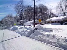
Many counties, including the rural areas across the Appalachian mountains and Delmarva averaged over two feet of snow.
The storm was well spotted by the winter storm reconnaissance (WSR) program at National Center of Environmental Predictions (NCEP). Two aircraft missions were deployed over the Pacific regions on February 1, 2010. Accurate measurement in the cloudy regions were taken, the data were assimilated by the global forecast models in different numerical forecast prediction centers.
The WSR program is led by Dr. Yucheng Song from the National Centers for Environmental Prediction (NCEP).
Source: CoCoRaHS
Source: NWS Washington/Baltimore Public Information Statement & Maps
Source: NWS Philadelphia/Mt. Holly Public Information Statement & Map
Source: NWS State College, PA Public Information Statement & Maps
Impact
Mexico
Freak winter rains across Mexico collapsed hillsides, sent rivers over their banks and left at least 15 people dead, officials said on Friday, February 5. The rain, which began early in the week and peaked on Thursday, February 4, had relented by Friday morning, providing officials with their first good look at the damage. More than half of the country was affected. The hardest area hit by the storm was the western state of Michoacán, a famous reserve for monarch butterflies, where at least 13 people were killed by landslides and flooding. An unknown number of people were missing Friday.[20] Other areas that were hard hit by flooding was the eastern Mexico City borough of Iztapalapa and municipalities in eastern State of Mexico such as Ciudad Nezahualcóyotl and Ecatepec de Morelos.[21] The rain broke records for February in Michoacán, the State of Mexico and Mexico City, with twice the normal amount for the entire month falling in 24 hours.[22] There was a silver lining: Officials said the copious rain had filled reservoirs outside Mexico City that are a key source of water for the metropolis. Water shortages had forced on-and-off rationing since last summer.[20] Water authorities state that most of the country now has a "positive balance" in reservoirs with 21,000,000 cubic metres (5.5×10⁹ US gal) of water added to reservoirs.[22]
United States
Southwest
The storm affected Arizona and New Mexico from February 1 to 4. Up to 1 foot (0.30 m) of snow fell in the mountains east of Albuquerque, New Mexico, while snow accumulations in the city varied from less than 1 inch (2.5 cm) near downtown to 5 inches (13 cm) on the West Mesa and in the far northeast foothills. Ice-covered roadways caused numerous accidents – including one fatal crash near Gallup – shutting down Interstate 40 through Tijeras Canyon and between Grants and Gallup for several hours on February 3.[23]
Deep south
Prolonged rains from Thursday morning through Thursday evening (February 4), produced widespread rainfall totals of 1 inch (2.5 cm) – 4 inches (10 cm) statewide with flooding reported in portions of Central and Southern Mississippi. The capital city of Jackson broke a daily rainfall record with 2.51 inches (6.4 cm) of rainfall.[24] Power outages were reported in North Carolina's mountain counties as the winter storm brought a mixture of snow, sleet and freezing rain to much of the state and rain to the rest, with about 40,000 outages late Friday afternoon (5 February). A drenching rain fell early Friday in the Charlotte and Atlanta area and then transitioned to a few inches of snow later in the day, while several inches of snow accumulated farther north. Parts of central and eastern North Carolina were under flood watches in advance of significant rainfall of up to 2 inches (5.1 cm).[25]
Midwest
Heavy snowfall occurred in Illinois, Indiana, and Ohio February 4–6. Snowfall totals ranged from 6 inches (15 cm) to over 1 foot (0.30 m) across the region. Drifts of up to 4 feet (1.2 m) were reported in central Indiana.[26]
The heavy snow, ice storms and low temperatures of January the 26th led to Interstate 90 being closed from Chamberlain, South Dakota, to the Minnesota border.[27] On the nightfall on Monday, Interstate 29 was closed from Sioux Falls to the North Dakota border.[27] Power company officials estimated that about 7,600 customers in South Dakota and 100 in North Dakota did not have power on Monday. Some phone systems also experienced brief telecommunications outages.[27] Kristi Truman, director of the North Dakota Office of Emergency Management was concerned about failing water and power supplies.[27]
In the Dakotas a number of Indian Reservations were left without power or running water.
"There's been winters this bad before, but not with rain so bad it freezes the power lines and snaps the poles", said Joseph Brings Plenty, the 38-year-old chairman of the Cheyenne River Sioux tribe.[28]
Power outages began with a storm in December knocking down around 5,000 power poles, and was accelerated by an ice storm Jan. 22 knocking down another 3,000 power lines on the reservation.
Among the tribes of South Dakota who suffered from the multiple storms were Cheyenne River Sioux, Crow Creek Sioux Tribe, Flandreau-Santee Sioux Tribe, Lower Brule Sioux Tribe, Rosebud Sioux Tribe, Sisseton-Wahpeton Oyate and Standing Rock Sioux Tribe.[29]
The Episcopal Church stepped in to help the reservations residents survive the winter.[30][31][32]
On February 1, utility crews worked overtime to get power back to the 14,000 residents of Cheyenne River Sioux Reservation.[33] The wind chill factor averaged about 25 °F below zero and there was about 1 foot of snow on average.[33]
Power outages in both the Dakotas power covered only 100 rural electric customers and minimal numbers in Bismarck, North Dakota by February, 5.[34]
Mid-Atlantic
The United States Government implemented an unscheduled leave policy for federal employees on Friday February 5 and shut down four hours early in an effort to clear metropolitan Washington before substantial snow accumulations began. Numerous school districts in the metro DC area announced closures for Friday February 5 well in advance, although District of Columbia Public Schools and some Maryland schools held a half day of class. Many districts had used all their built-in snow days and some began scheduling classes on upcoming holidays (for example, Fairfax County on February 15, the Monday of President's Day weekend).[35] Late on Sunday February 7, the Office of Personnel Management announced that the United States Government would again be closed on Monday February 8, with only emergency/essential personnel required to report, and numerous school districts again canceled classes between February 9–11.
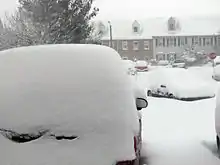
As of shortly after midnight on February 6, more than 50,000 homes and businesses in the Washington, D.C., metropolitan area were without electricity. In northern Virginia, the total was 33,000 and in northern Maryland and the District of Columbia the total was 19,000. Roadways were blanketed with snow, Metro bus service ended at 9 pm EST, and above ground Metro rail service had also ended. Flights were canceled at the Washington-Baltimore area's three main airports and at Philadelphia International Airport. Delta Air Lines had suspended flights in and out of Washington, Baltimore, and Philadelphia. A Washington Wizards game was postponed due to the storm.[36]
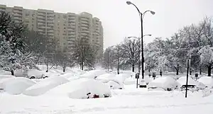
In Maryland, the Maryland Transit Administration ran special snow trains on its heavy rail and light rail lines to keep tracks clear. Delaware Gov. Jack Markell declared a state of emergency Friday night and ordered all vehicles off the roads by 10 p.m. EST (this was in addition to an earlier state of emergency declared by Virginia Gov. Bob McDonnell and snow emergencies declared in the District of Columbia and some Maryland counties).[37] Maryland was under a state of emergency as of mid-day on February 6, as state and county road crews said they were struggling to keep even one lane open on major roads and 151,000 customers were without power in Maryland, including 34,000 Baltimore Gas and Electric Co. customers in the region. Cars were left abandoned on highways, trees came down and Humvees were used to ferry patients to local hospitals.[38] The United States Postal Service decided to cancel mail delivery and collection in the affected areas for Saturday, February 6.[35]
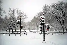
The weight of the snow caused several roof collapses throughout the Washington area. Most notably, the roof of a hangar housing private jets at Dulles International Airport caved in twice due to the snowfall.[39] Also reported were the collapse of a house roof in Northeast, Washington, D.C., a house in the Luxmanor Area in Rockville, Maryland, which collapsed from a fire that resulted from trying to melt the snow from the roof, the entire Prince William Ice Center in Dale City, Virginia,[40] and the total collapse of a warehouse in California, Maryland. In none of the four cases were there reports of injuries.[41] Around 2 pm EST on February 6, DC fire and EMS personnel responded to a church collapse in Northeast DC–preliminary reports from the scene were that the weight of the heavy snow caused the 1- or 1+1⁄2-story wooden building to completely collapse, and subsequent gas leaks caused some neighbors to be evacuated.[42] The roof of St. John's School in Hollywood, Maryland, also collapsed,[43] as did the roof of the truck bay at the volunteer fire station in Bailey's Crossroads, Virginia, on the morning of Monday February 8, but there were no injuries.[44]
Amtrak shut down much of their service in the region, canceling its Silver Meteor, Silver Star, Crescent, Carolinian, Palmetto, and Capitol Limited, as well as canceling Cardinal service past Huntington, West Virginia However services north continued to operate through the teeth of the storm on a limited schedule.
In Pittsburgh, both the impact and severity of the storm caught many by surprise. Snow began falling in earnest late Friday morning. The sudden onset of the storm forced many local school districts, especially districts south of the city, to close early due to rapidly deteriorating road conditions; this is an extremely uncommon event for schools in southwestern Pennsylvania.[45] Nearly all schools, including the Pittsburgh Public Schools, cancelled classes the following week. Most local universities were also forced to cancel classes for much of the following week due to the storm's effects. Additionally, over 130,000 people in the Pittsburgh area were without power as a result of the heavy, wet snow.[46] For many residents, power was not restored until Monday, February 15.
Notable events
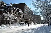
Washington, D.C.

Many cross-country skiers were spotted throughout Washington, D.C., during the blizzard. Photographs of two skiers were shown in several regional newspapers, making them an iconic image of the storm and local celebrities.[47]
Casualties
Mexico
Three children died when their home in Angangueo was overwhelmed by a flooded river, and two other people died under a landslide in Zitácuaro. A sixth victim was crushed beneath a collapsed wall of a home in Ocampo. Two children drowned trying to cross the swollen Chapulin River in the central state of Guanajuato.[20] In total, twenty eight deaths in the states of Michoacán, Mexico State and the Distrito Federal (Mexico City) have been attributed to the storm.[48]
United States
New Mexico
On February 3, 2010, a family from California was traveling east on snow-covered Interstate 40 near Gallup, New Mexico, when the driver hit a patch of ice, sending their pickup truck across the median into the westbound lanes, striking an oncoming vehicle, killing the adult passenger, and leaving the driver, the child, and the driver of the westbound vehicle critically injured.[49]
Indiana
On February 5, 2010, Brendan Burke, son of Toronto Maple Leafs General Manager Brian Burke, was killed while driving in Economy, Indiana, near the Ohio border. While driving in heavy snow, his 2004 Jeep Grand Cherokee slid sideways into the path of an oncoming Ford truck, killing him and his passenger, Mark Reedy (18) of Bloomfield Hills, Michigan.[50]
Virginia
On February 6, 2010, a father and son were rendering aid to the occupants of a disabled vehicle on Interstate 81 in Virginia. A tractor trailer that was approaching the scene jackknifed and killed the men.[51]
Maryland
In Maryland, a family was traveling north of Aberdeen on Route 462 when they ran into the back of a snow plow. Maryland State Police said that the accident was serious.[52] In Bladensburg, two men were found dead in a running car whose tailpipe was blocked by snow; they died of carbon monoxide poisoning.
Delaware
In Delaware, officials investigated 8 deaths in New Castle County related to the storm. Two men were found under snow piles and a third suffered from dementia and wandered outside only to be found an hour later by a family member half buried in snow.[53]
Pennsylvania
A father and daughter in McKeesport were killed by carbon monoxide poisoning, as a result of improper usage of a generator after a power outage.[54][55] A Canonsburg man was found dead at the bottom of a snow-covered staircase.[56] Twenty five vehicles were involved in two separate pileups on Interstate 80, killing one and injuring eighteen.[57] Two were killed in Lancaster when their snowmobile was struck at an intersection.[58]
Visualization
See also
References
- ↑ "FEBRUARY 2010: Snowmageddon, Blizzard of 2010 WINTER: Unprecedented Snowfall Impacts Region" (PDF). NOAA. Retrieved 2016-12-03.
- ↑ "Welcome to Comparative Snowpocalypse Analysis 101". DCist. 2010-02-06. Archived from the original on 9 February 2010. Retrieved 8 February 2010.
- ↑ David Morgan; Eric Beech (2010-02-06). "Powerful snowstorm hits U.S. East Coast". Reuters. Retrieved 6 February 2010.
- ↑ "February 6, 2010 Blizzard Conditions".
- ↑ "Storm Summary Number 03 for Northern Rockies and Plains Winter Storm". NWS Weather Prediction Center College Park MD. April 24, 2022.
- ↑ "STORM SUMMARY MESSAGE". Weather Prediction Center – NOAA. Retrieved 2016-12-03.
- ↑ Ostro, Stu (2010-02-05). "Early-mid February is going to do it *yet again*!". The Weather Channel. Archived from the original on 9 February 2010. Retrieved 6 February 2010.
- ↑ "BBC News – 'Snowmageddon' still gripping Washington and eastern US". news.bbc.co.uk. February 8, 2010. Retrieved 2010-02-08.
- ↑ "Chicago Tribune – Obama names a storm". Chicagotribune.com. Retrieved 2010-02-10.
- ↑ "Snowmageddon vs. Snowpocalypse: Which Cute Nickname Will Win?". Gawker.com. 2010-02-08. Archived from the original on 9 February 2010. Retrieved 8 February 2010.
- ↑ "Vote for storm name, Twitter hashtag & snow total". The Washington Post. February 4, 2010. Retrieved February 11, 2010.
- ↑ Broder, John M.; Healy, Jack (February 5, 2010). "East Coast Is Hit by 'Potentially Epic Snowstorm'". The New York Times. Washington. Retrieved February 11, 2010.
bracing for what newspapers and bloggers have been calling the "snowpocalypse," or "snowmageddon,"
- ↑ Gainor, Dan M. (February 10, 2010). "Washington's New Four-Letter Word: Snow". Fox News. News Corporation. Reuters. Retrieved February 12, 2010.
D.C. residents have turned to social media like Twitter and FaceBook to vent their frustration with terms like "snOMG," "snowmageddon," "snowpocalypse," and "kaisersnoze."
- ↑ "Powerful blizzard shuts down US capital". Google news. AFP. February 5, 2010. Retrieved February 11, 2010.
The storm, dubbed "Snowpocalypse" and "Snowmageddon" by many locals,
- ↑ "Obama calls capital's blizzard 'Snowmageddon'". Google news. Associated Press. February 6, 2010. Retrieved February 11, 2010.
- ↑ "Snow Depth Measurement from 2010 Becomes Delaware Record". www.wboc.com.
- ↑ Neiburg, Jeff. "Delaware has a new daily snow depth record ... 11 years later". The News Journal.
- ↑ Tynan, Cecily (February 6, 2010). "Historic Snowstorm!". WPVI-TV. Archived from the original on February 5, 2010. Retrieved 2010-02-07.
- ↑ "Snow storm bears down on Mid-Atlantic region, including Harrisburg area". The Patriot-News. February 9, 2010. Retrieved 2010-02-10.
- 1 2 3 Ellingwood, Ken (February 6, 2010), "Mexico rainstorms leave at least 15 dead", Los Angeles Times.
- ↑ Robles, Johana (2010-02-05). "Baja probabilidad de lluvia en Valle de México" [Low probability of rain in the Valley of Mexico]. El Universal (in Spanish). Mexico City. Retrieved 2010-02-07.
- 1 2 "Lluvia histórica sube nivel del Cutzamala" [Historic rain raises level of the Cutzamala]. El Universal (in Spanish). Mexico City. 2010-02-04. Archived from the original on February 8, 2010. Retrieved 2010-02-07.
- ↑ "Snow Closes I-40 West, Slows Many Roads, KRQE TV Albuquerque, NM, Accessed Feb 6, 2010". Archived from the original on February 6, 2010.
- ↑ Rain drenches the state of Mississippi on Thursday; record rainfall in Jackson February 5, 11:24 am Jackson Weather Examiner Johnny Kelly
- ↑ "Latest winter storm brings a little of everything to North Carolina: snow, ice, sleet and rain By Associated Press 4:44 pm EST, February 5, 2010".
- ↑ Service, US Department of Commerce, NOAA, National Weather. "Indianapolis, IN". www.crh.noaa.gov.
{{cite web}}: CS1 maint: multiple names: authors list (link) - 1 2 3 4 staff, Andrea J. Cook, Journal. "Power and water shortages cripple reservation".
{{cite web}}: CS1 maint: multiple names: authors list (link) - ↑ Millman, Joel (January 28, 2010). "Storm Takes Steep Toll on Destitute Tribe". The Wall Street Journal.
- ↑ "Indian Country Media Network – Native News, Art & Traditions". www.indiancountrytoday.com.
- ↑ Rodda, Chris (January 27, 2010). "Emergency Help Desperately Needed to Heat Homes on the Pine Ridge Reservation". Huffington Post.
- ↑ "Episcopal Life Online - DIOCESAN DIGEST". Archived from the original on 2010-02-11. Retrieved 2010-02-09.
- ↑ "Many on South Dakota Reservation Remain Without Power After Storm". The New York Times. February 1, 2010. Retrieved May 2, 2010.
- 1 2 "AOL On – Orangutan Steals Man's Shirt". 19 April 2013. Archived from the original on 19 April 2013.
- ↑ "Latest North Dakota news, sports, business and entertainment:... | KXNet.com North Dakota News". Archived from the original on 2011-07-23.
- 1 2 Halsey, Ashley III & Weil, Martin (February 6, 2010), "Snowstorm's intensity has D.C. region hunkering down", Washington Post.
- ↑ Hawks, Wiz can't make trips for game, ESPN, February 6, 2010
- ↑ Morrison, Greg (February 6, 2010), "Travel grinds to halt after powerful mid-Atlantic snowstorm", CNN.
- ↑ Roylance, Frank D.; Bowie, Liz; Dresser, Michael & Wheeler, Timothy B. (February 6, 2010), "'Extremely dangerous' storm buries Md. in snow Residents urged to stay at home, off roads; BWI, most transit operations shut down", Baltimore Sun, archived from the original on February 13, 2010, retrieved February 6, 2010.
- ↑ McFadden, Robert D. (February 7, 2010), "Capital Is Crippled as Blizzard Continues", The New York Times, retrieved May 2, 2010.
- ↑ Supak, Supak, "Prince William Ice Center collapses", InsideNOVA.com, archived from the original on 2010-02-08.
- ↑ "WTOP: Washington, DC's Top News, Traffic, and Weather". WTOP.
- ↑ Coyle, Jillian, "Northeast DC Church's Roof Collapses", WUSA 9, archived from the original on 2016-03-03, retrieved 2010-02-06.
- ↑ "Roof of Elementary School Collapses | ABC 7 News". Archived from the original on 2010-02-09. Retrieved 2010-02-08.
- ↑ "FCNP.com, Roof of Firehouse in Bailey's Crossroads Collapses Under Weight of Snow Monday, February 08 2010 12:43".
- ↑ "Early Dismissal? Schools Consider Options Ahead of Snow - Pittsburgh News Story - WTAE Pittsburgh". Archived from the original on 2010-02-06. Retrieved 2010-02-26.
- ↑ "Thousands of Customers Without Power in Western Pennsylvania - kdka.com". Archived from the original on 2010-03-13. Retrieved 2010-02-27.
- ↑ "Blizzard Blasts Eastern U.S. "Blizzard blasts eastern US, Washington snowed under | the Jakarta Globe". Archived from the original on 2011-01-14. Retrieved 2010-02-11.
- ↑ "Intensas lluvias en México han dejado 28 muertos" [Intense rains have left 28 dead]. La Crónica (in Spanish). Mexico City. EFE. 2010-02-05. Retrieved 2010-02-07.
- ↑ California Woman Killed in New Mexico Car Crash, Fresno Bee, Accessed Feb 6, 2010
- ↑ Boesveld, Sarah; Mirtle, James (February 5, 2010), "Brian Burke's son killed in auto accident", The Globe and Mail, retrieved January 22, 2019
- ↑ "2 Die In Accident During Snowstorm In Va". The Associated Press. 2010-02-05. Archived from the original on 8 February 2010. Retrieved 6 February 2010.
- ↑ Bolden, Michael (2010-02-05). "Accidents on the rise in Md., Va". The Washington Post. Retrieved 6 February 2010.
- ↑ "delawareonline". delawareonline.
- ↑ Kane, Karen (February 8, 2010). "Two dead, dozens sickened trying to keep warm". Pittsburgh Post-Gazette. Retrieved 8 February 2010.
- ↑ "Father, Daughter Dead In McKeesport; Carbon Monoxide Suspected". WTAE. Archived from the original on 10 February 2010. Retrieved 8 February 2010.
- ↑ Thomas, Lillian (February 8, 2010). "Canonsburg man found dead at bottom of staircase". Pittsburgh Post-Gazette. Retrieved 8 February 2010.
- ↑ CTV.ca News Staff (February 10, 2010). "Snow records fall as storm sweeps across Mid-Atlantic". CTV News. BellMedia. Retrieved January 22, 2019.
- ↑ Syeed, Nafeesa. "Enough already: Snow breaks mid-Atlantic records". Associated Press. Retrieved 10 February 2010.
External links
- "Washington gets hit with a winter wallop", photo gallery by The Washington Post
- "Snowstorm Slams the East Coast", photo gallery by The New York Times
- "'Snowmageddon' in D.C.", video report by CBS News
- "Dupont Circle Snowball Fight" video report by The Washington Post
- "Timelaps NEXRAD Radar Animation", Atmospheric Physics group at UMBC
- Snowmageddon, five years later: The first of two Mid-Atlantic blizzards in February 2010
