Fraissinet-de-Fourques | |
|---|---|
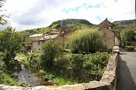 A view from the bridge over the river in Fraissinet-de-Fourques | |
Location of Fraissinet-de-Fourques | |
 Fraissinet-de-Fourques  Fraissinet-de-Fourques | |
| Coordinates: 44°12′58″N 3°32′23″E / 44.2161°N 3.5397°E | |
| Country | France |
| Region | Occitania |
| Department | Lozère |
| Arrondissement | Florac |
| Canton | Le Collet-de-Dèze |
| Intercommunality | CC Gorges Causses Cévennes |
| Government | |
| • Mayor (2020–2026) | Daniel Reboul[1] |
| Area 1 | 24.30 km2 (9.38 sq mi) |
| Population | 81 |
| • Density | 3.3/km2 (8.6/sq mi) |
| Time zone | UTC+01:00 (CET) |
| • Summer (DST) | UTC+02:00 (CEST) |
| INSEE/Postal code | 48065 /48400 |
| Elevation | 660–1,343 m (2,165–4,406 ft) (avg. 740 m or 2,430 ft) |
| 1 French Land Register data, which excludes lakes, ponds, glaciers > 1 km2 (0.386 sq mi or 247 acres) and river estuaries. | |
Fraissinet-de-Fourques (French pronunciation: [fʁɛsinɛ də fuʁk]; Occitan: Fraissinet de Forcas) is a commune in the Lozère department in southern France.[3]
See also
References
- ↑ "Répertoire national des élus: les maires" (in French). data.gouv.fr, Plateforme ouverte des données publiques françaises. 13 September 2022.
- ↑ "Populations légales 2021". The National Institute of Statistics and Economic Studies. 28 December 2023.
- ↑ INSEE commune file
Wikimedia Commons has media related to Fraissinet-de-Fourques.
This article is issued from Wikipedia. The text is licensed under Creative Commons - Attribution - Sharealike. Additional terms may apply for the media files.