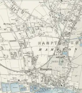
| Hampton | |
|---|---|
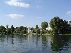 The River Thames at Hampton | |
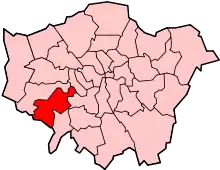
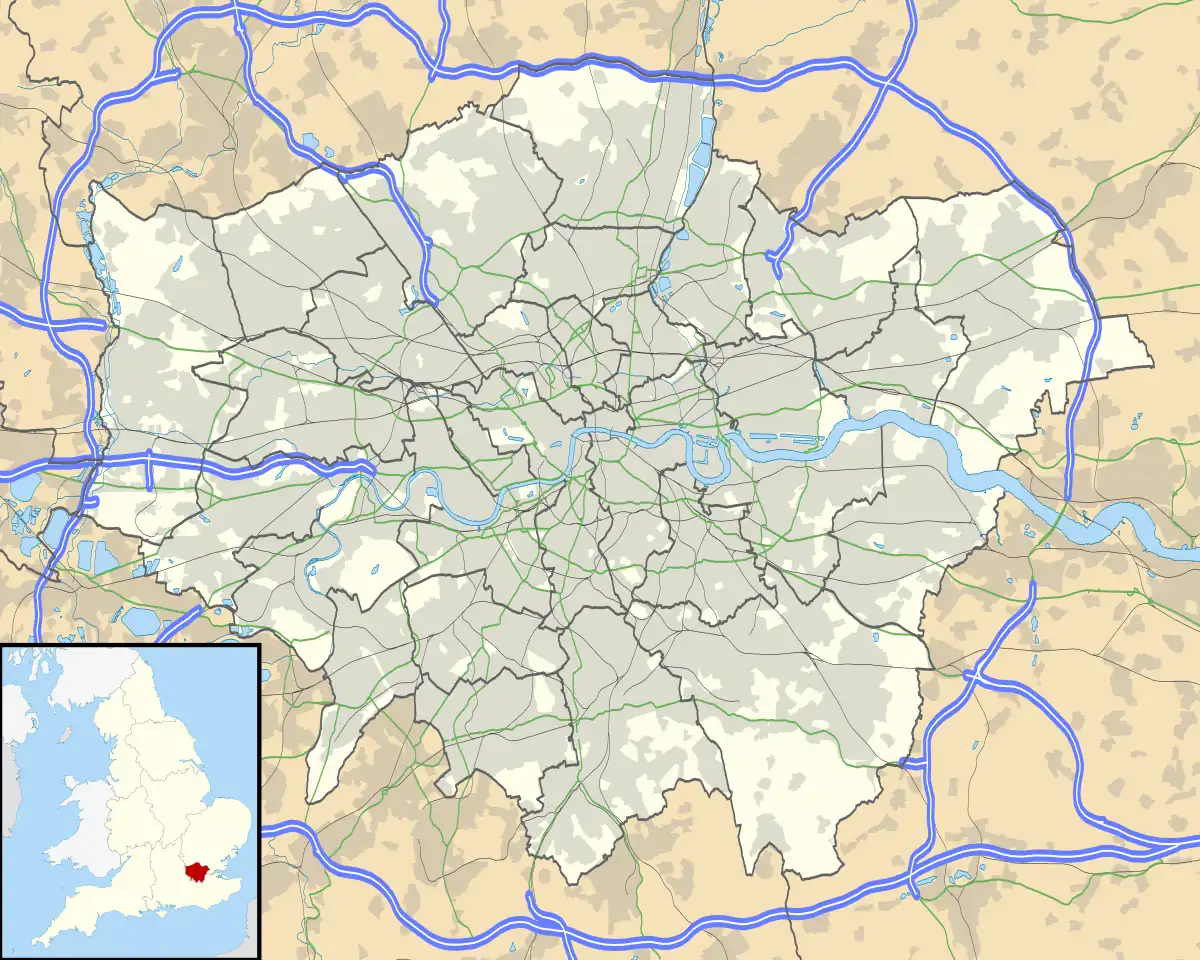 Hampton Location within Greater London | |
| Area | 8.83 km2 (3.41 sq mi) |
| Population | 20,000 [1] |
| • Density | 2,265/km2 (5,870/sq mi) |
| OS grid reference | TQ135705 |
| London borough | |
| Ceremonial county | Greater London |
| Region | |
| Country | England |
| Sovereign state | United Kingdom |
| Post town | HAMPTON |
| Postcode district | TW12 |
| Dialling code | 020 |
| Police | Metropolitan |
| Fire | London |
| Ambulance | London |
| UK Parliament | |
| London Assembly | |
Hampton is a suburban area on the north bank of the River Thames, in the London Borough of Richmond upon Thames, England, in the historic county of Middlesex. Hampton is bounded by Bushy Park to the east (and to the north of St Albans Riverside facing Tagg's Island), the suburbs of Hampton Hill and Fulwell to the north, green belt to the west,[2] and the Thames to the south. Historically, the area known as Hampton included Hampton Court Palace (and Bushy Park), Hampton Hill, and Hampton Wick (which are now known collectively as "The Hamptons").
Hampton is the site of the Hampton Water Treatment Works, which supplies around 30% of London's fresh water. Hampton is primarily residential, served by Hampton station on the Shepperton branch line to London Waterloo, as well as Hampton Court station.
History
Pre-history
The River Thames was displaced southwards to its present course through Berkshire and London following the Anglian glaciation c. 450,000 BCE. The local geology comprises Kempton Park Gravel above London Clay, on which the Thames deposits fertile, well-drained alluvial soils, making it an attractive area for human habitation and settlement.[3][4][5]
There is evidence of small hunter-gatherer communities in the Thames Valley in the Palaeolithic period, who would have hunted migrating animal herds (reindeer and horse) depending on seasonal conditions. Hand-axes and a flint from that era have been recovered from sites in Hampton, indicating the presence of human activity as early as the Wolstonian Stage.[6]
The resettlement of Britain following the Last Glacial Maximum and the start of the Holocene is evidenced in Hampton and surrounding areas by the artefacts (predominantly flintwork) of Mesolithic hunter-gatherers, who would have favoured the diversity of habitats and food resources offered by rivers and their floodplains for settlement and resource procurement.[7] Three Mesolitihic tranchet axes were discovered during construction of the Hampton Waterworks.[5][8]
Evidence of Neolithic and Bronze Age settlement activity in the area is widespread, during a period when the level of the River Thames would have been significantly lower than at present. Finds on Garrick's Ait (Neolithic stone axe), Hurst Park (Neolithic pits), and Platt's Eyot (early Bronze Age axe); and the excavation in 1854 of a significant Bronze Age barrow in Bushy Park (containing the cremated remains and offerings of a local chieftain) indicate the transition to settled agriculture.[5][9]
Before the Roman invasion of Britain, the Hampton area was occupied by the Catuvellauni, a Celtic tribe with its centre of government at Watamestede, near modern-day St Albans. There is little archaelogical evidence of Roman activity in the Hampton area (which was concentrated around the river crossing at Kingston-upon-Thames), except for a small collection of finds at Hampton Hill,[5] a corn drier in Hurst Park,[10] and field boundaries laid out to Roman proportions in what would become Bushy Park.[11]
Anglo-Saxon Hampton and the Norman Conquest
Following the end of Roman rule the Hampton area would have been on the fringes of the Anglo-Saxon Kingdom of Mercia, in territory which came to be known as Middlesex.[12] The settlement of Hampton first developed under the Saxons, centred on a village clustered around the intersection of roads which became modern-day Thames Street, Church Street and High Street, and the hillock on which St Mary’s Church stands. The Anglo-Saxon parish of Hampton included the area comprising present-day Hampton, Hampton Hill, Hampton Wick, Bushy Park, parts of Teddington, and Hampton Court.[13]
The Hampton settlement developed under the manorial system (where tenant serfs work the arable farm and grazing land of the manor on behalf of the absentee lord) as an agricultural domain supporting neighbouring Kingston, which by the 9th century was a significant royal estate.[14][15][lower-alpha 1] Bushy Park shows extensive use of the ridge and farrow system of agriculture introduced by the Saxons.[11] The 1086 Domesday Book records that prior to the Norman Conquest the Manor of Hampton belonged to Aelfgar, Earl of Mercia, but indicated that, as Aelfgar had not passed his lands to his son Edwin upon his death in 1062, they were instead held by King Harold at the time of the Norman Invasion.[lower-alpha 2][16]
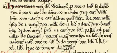
The name Hampton may come from the Anglo-Saxon words hamm meaning an enclosure in the bend of a river and ton meaning farmstead or settlement.[17][lower-alpha 3] Hamntone is recorded in the Domesday Book,[lower-alpha 4] the entry listing 41 villagers and 4 smallholders (accounting for households comprising ~200 individuals) occupying 35 hides, each comprising the area that could be ploughed by eight oxen in a year (~120 acres, or ~4,200 acres total). The demesne (lands belonging to the lord of the manor) comprised 18 hides tilled by only 3 ploughs, indicating it was used mostly for sheep pasture.[18] The other 17 villanes (hides leased to serfs) each had a plough, suggesting cultivation. The entry also recorded a substantial meadow (for the provision of hay for plough animals) and a significant fishery.[19][20][21][lower-alpha 5]
The Domesday Book records the total annual value of the estate in 1086 (used to calculate how much tax the lord should be charged) as 39 pounds. The assessed 1086 value was 9 pounds less than prior to the conquest, attributed to the devastation caused by Norman forces on their circuitous route around London as they sought its subjugation.[22]
After the Conquest the Manors of Hampton and Isleworth (comprising the hundred of Hounslow) were granted to Walter of Saint-Valéry, from whose home town in Flanders, Saint Valery-sur-Somme, William had sailed in 1066.[lower-alpha 6][23] Walter probably never resided in Middlesex, and he and his heirs were active participants in the First and Second Crusades.[24] In 1189 the estate passed to Thomas de St Valerie, who, as a baron in the "extraordinarily difficult" position of holding large possessions on both sides of the English Channel in the time of Magna Carta and the rebellion against King John, appears to have taken the precaution of severing the two holdings -- transferring the Manor of Hampton to Henry de St Albans, a London merchant, and the Manor of Isleworth to his daughter Annora's husband, Robert III of Dreux -- at some point before the 1217 Battle of Lincoln (in which he was implicated and ultimately exiled).[25][24] The Manor of Hampton transferred from the hundred of Hounslow to that of Spelthorne in the late 12th or early 13th century.[26]
Medieval Hampton and the Knights Hospitaller
The Manor was acquired in 1237 by the Order of Knights of the Hospital of Saint John of Jerusalem (known as the Knights Hospitaller). A Benedictine order charged with the care and defence of the Holy Land[lower-alpha 7], the Knights Hospitaller operated from headquarters on Rhodes, using their holdings in England (received via bequests from returning Crusaders) to fund their operations. The Order became established in Hampton around 1180[lower-alpha 8] (probably by a gift from Reginald St Valery[lower-alpha 9]), and by 1237 owned a house and sheep pasture on the site of present-day Hampton Court Palace.[24] In 1338, the Order commissioned a financial survey of its possessions in England, which showed the Manor of Hampton comprising 800 acres of demesne (rented arable land), 40 acres of meadow by the Thames, pasture for 24 oxen, 18 cows, 10 store cattle and 2000 sheep, a fish weir and a pigeon house.[27][28]
The Knights Hospitallers developed their estate at Hampton Court into one of the largest and best-appointed of their manors in England, and it was frequently used by the royal court as alternative accommodation to Sheen Palace (the royal palace on the Thames at Richmond[lower-alpha 10]), and as a way station and guest house for visitors en route to the royal manor at Byfleet (constructed by Edward II in the early 14th century).[29]
The destruction by fire of Sheen Palace in 1497 saw the royal court move to Hampton Court. In 1500 the Lord Chamberlain Sir Giles Daubeney ordered that 300 acres of the demesne near Hampton be enclosed for hunting, taking out a lease for the entire manor in 1505. After his death in 1508, the lease passed to Sir Giles' wife, who allowed it to lapse. Cardinal Wolsey purchased the lease from the Knights Hospitaller in 1514, and continued development of the site into the historic palace ultimately acquired by Henry VIII after Wolsey's demise in 1530.[30]
Post-medieval Hampton
The 1534 Act of Supremacy enshrining Henry VIII as supreme head of the Church of England saw the expropriation of Catholic properties throughout England. The Knights Hospitallers Order was formerly dissolved by an Act of Parliament in 1540 and the manor annexed by the Crown.[31] In 1536 Henry acquired part of Teddington from the Abbot of Westminster, enclosing the land for hunting. In 1537 Henry emparked the arable land around Upper Lodge and ordered the construction of brick walls from Hampton Court to Teddington and Hampton Wick. The boundaries of modern-day Bushy Park were set in 1620 with the addition of the Hampton Eastfield (nearest the town).[32] [33]

The supply of water for the ever-increasing population of the royal complex at Hampton Court had been problematic since the time Wolsey had first taken the Hospitallers' lease,[lower-alpha 11][34] but it was not until Charles I ordered the construction of a canal connecting the River Colne to the Thames via Hampton Court that the palace secured a steady supply for its household and expanding water features. Designed by Nicholas Lane, the canal started at Longford on the Colne, and was built swiftly in 1638–39, cutting through Feltham, Hanworth, Hounslow Heath, and the north Hampton heath on its route to Bushy Park. Initially unpopular for blocking roads and dividing parishes, the original river (variously known as the Cardinal's, Queen's or King's River) was poorly made and prone to flooding. Protesters dammed the river in 1649 and the river fell into disuse and ran dry during the Protectorate. After the Restoration, Charles II sought to replicate in Bushy Park the garden at Versailles, establishing the Long Water in Home Park as a wedding present for Catherine of Braganza, and thus ordered the Longford River restored.[35][36][37]
Between 1500 and 1700 the population of Hampton and Hampton Wick grew from 300–350 to 1100–1200,[38] despite outbreaks of plague in 1603–06 and 1665–66. The population of Hampton and its surrounding area may have been bolstered by the migration of London citizens out of the city: Charles II moved his court to Hampton Court in July 1665 before again moving to the relative safety of Oxford the following September.[39][40][41]
Hampton in the 19th century
Hampton recorded a population[lower-alpha 12] of 1,722 in the Census of 1801. An Inclosure Act applicable to Hampton was passed in 1811,[42] which led to the parcelling and enclosure of common land, and a steady increase in population. St Mary's Church was demolished in 1829 and replaced by the present larger building in 1831, at which time the parish of Hampton Wick was separately established.[lower-alpha 13] The parish of Hampton Hill was established in 1863.
In 1838 the restoration of the Great Hall of Hampton Court Palace was completed, and Queen Victoria opened the palace to the public, which became a major tourist attraction. Visitor numbers increased further following the opening of the Hampton Court branch line (off the London and Southampton Railway mainline) in 1849.[43]
The passage of the Metropolis Water Act 1852 made it unlawful for any water company to extract water for domestic use from the tidal reaches of the Thames (i.e. below Teddington Lock). This led to the Southwark and Vauxhall, Grand Junction and West Middlesex water companies to jointly construct water works on the Thames at Hampton, between the Sunbury and Molesey Locks, which began operations in 1855 (see below).
The Shepperton branch line, including Hampton and Fulwell stations, was opened in 1864, and electrified in 1916. The curve of the railway line would come to define the suburb of Hampton distinct from the original village. The 'New Street' (now Station Road) was developed along the route of a historic trackway to link Hampton Station to the village.[44]
The rapid growth and urbanisation of 19th-century London saw agricultural production pushed out to its perimeter, and in Hampton land which had been used for grazing and farming was enclosed and converted to market gardens, to service the increased demand from markets in and around London. The nurseries would continue to expand production until after World War II.[45]
Between 1811 and 1851 the population of Hampton grew from 1,984 to 3,134, and by 1911 had reached 9,220.[46]
Modern Hampton
Hampton developed into its current form of a residential suburb of London over the course of the late 19th and 20th Centuries, as the families of professional workers settled within commuting distance of the city, and demand for local shops and services grew.[47] The passage of the Local Government Act 1858 allowed for the creation of elected Local Boards, which, unlike civil parishes, had the power to borrow money against future revenue, allowing for capital projects. Hampton residents initially voted in 1865 against establishing a Local Board, but after being subsumed into the Kingston Rural Sanitary Authority in 1872, voted in favour of establishment in 1884. Permission was however denied on the basis of Hampton being too small an area, and a Local Board was not created for Hampton until 1890. The Board converted to an Urban District Council in 1895, and established its office in Rosehill in 1902.[48]
Hampton fire station was built in 1897.[44] A police station had operated in Hampton since 1846, but moved to a "a new and more commodious Police Station ... erected in Station Road near the World’s End public house" in 1905.[49] London United Tramways extended its network from Twickenham to Hampton, Hampton Court, East Twickenham (just west of Richmond Bridge) and Teddington in 1903.[50] Hampton Pool was built in 1922 (on land previously occupied by the Hampton and Hampton Hill Rifle Club) after plans approved in 1914 were delayed due to the outbreak of the World War I.
A telephone exchange was built in 1927 (a four storey building on High Street, Hampton), as a replacement for the original telephone exchange at Manor Road in Molesey (hence known as the Molesey Telephone Exchange). The exchange switched from manual operation to Subscriber Trunk Dialling in the 1960s, and enabled for ADSL broadband internet in 2000.[51][52][53]
The modern streetplan was laid out following old lanes and field boundaries.[54] Suburban infill of the area north of Hampton Station delineated by the railway line took place mostly throughout the Interwar period.[55]
By the 1960s the Hampton nurseries began to face competition from overseas and domestic produce sourced using refrigeration, air freight and cheaper labour, and ultimately became uncompetitive and increasingly derelict. After a lengthy planning process, work to develop the area into the Nurserylands Housing estate began in 1980.[45] The population of Hampton North / Hampton Nursery rose from 3,977 to 6,426 between the 1981[56] and 1991[57] Censuses.
The population of Hampton in the 2021 Census was recorded as 27,307, with 77.4% recording the United Kingdom as their country of birth.[58] During the Covid-19 pandemic, 52% of Hampton residents in employment recorded in the 2021 Census that they worked mainly from home, compared to 32% for England,[59] reflecting Hampton's status as a commuter suburb.
Hampton and the River Thames
Hampton stands on the north bank of a bend in the River Thames, and has a close historical association with the river as a trading post and commercial/industrial centre. Boatyards and slipways have led down to the river from the village for centuries. Benn's boathouse on Thames Street was reputed to have been built before 1704 (being demolished in 1946-7[60] and merging with Constable's boatyard next door).[61] As Henry Ripley wrote in 1883:[62]
And what a view it is that strikes the observer when at length he reaches the "Bell" Hill, especially if he makes its first acquaintance at the close of a fine summer's day!
...
The fishing punts moored in the Deeps, the numerous sailing-craft (chiefly claiming affinity with the Thames Valley Sailing Club) cruising merrily about, the countless row-boats with their gay and merry occupants, the constant relays of steam-launches, ruining the fishing and river banks, and keeping timid oarsmen in perpetual fear and dread, the noisy tugs, churning the river into masses of foam as they haul in their wakes long strings of heavily-laden barges, the picturesque picnic parties on Garrick's Eyot, with the comfortable-looking and gaily-decked house-boats moored under its banks; all those features (to begin with) form a picture that rivets the eye and impresses the mind at once.
— Henry Ripley, The History and Topography of Hampton-on-Thames, 1883

Islands
Modern Hampton comprises Platt's Eyot, Benn's Island and Tagg's Island, but historically also includes Garrick's Ait and Ash Island.
Platt's Eyot
Platt's Eyot is a large island opposite the Hampton Water Treatment Works. Historically willow was cultivated on the island, the osiers being strong, flexible and resistant to rot, and suitable for fish traps, basket-making and reinforcing riverbanks. The first boatyard on the island was constructed on the eastern end in 1866 by Thomas Tagg. In 1904 shipbuilder John Isaac Thornycroft established the Hampton Launch Works, generating cabin cruisers and pleasure craft. During wartime, production shifted: to torpedo-carrying motor launches in the First World War, and constructing motor torpedo boats, motor launches and landing craft during the Second World War.[63]
In 1910, the height of the island's western end was augmented by fill from the excavation of the Stain Hill Reservoirs. The island was connected to the north bank of the Thames by a pedestrian bridge in 1941. Boat building ceased in the 1960s and the boatsheds reverted to light industrial use, including being used as music studios.[64] The boatyards were largely destroyed by fire in 2021.
Benn's Island
Benn's Island is a small uninhabited island close to the Hampton riverbank below St Mary's Church. In the 19th century the island was occupied by the Thames Valley Sailing Club (since relocated to Sunbury Lock Ait), and since 1945 has been leased by the Hampton Sailing Club.
Tagg's Island
Tagg's Island is an inhabited private island surrounded by 62 houseboats in a self-styled community of artists and creatives. Historically, the island has been the site of multiple hotel and resort developments, including the Island Hotel established by Thomas Tagg (after whom the island is named), the famous Karsino built by impresario Fred Karno, which, following Karno's bankruptcy, became known as the Thames Riveria under various owners. The island was bought by car manufacturer AC Cars in 1940, who converted the skating rink and tennis courts into factory space for wartime munitions, and later, Invacars for the Ministry of Pensions. The hotel was demolished in 1971. In 1980 houseboat owners Gerry and Gillian Braban bought the island, excavating a lagoon in the centre of the island (increasing the number of houseboats by 20) and rebuilding a road bridge to the north bank.
River crossings

Hampton Ferry has linked Hampton to the south bank of the Thames at Hurst Park, Molesey since at least 1514, and reputedly since the time of the Domesday book.[44]
A ferry had also operated linking Hampton Court to present-day East Molesey since the Tudor period, with a bridge first constructed on the site in 1753. The present-day Hampton Court Bridge, opened in 1933, is the fourth iteration.
Locks and river management
Hampton lies on the River Thames upstream of Molesey Lock and downstream of Sunbury Lock.
The River Thames has always been a key waterway for the supply of goods along its banks and in and out of London. In the 19th century, barges carrying up to 200 tons of material, hauled by men or horses along tow paths, were a common sight along the Hampton/Molesey Reach and an integral part of the river economy. But as river traffic increased, the ad hoc wooden weirs and dams constructed to maintain the river level became unsatisfactory. A lock was first proposed to manage the shallows at "Kenton Hedge and Sundbury Flatts above" in 1802, but it was not until 1812 that Parliament passed an Act for the construction of a lock, and Molesey Lock was completed in 1815. There had been a weir at Sunbury to divert water for better navigation since 1789, and the first lock was opened in 1812. The lock was rebuilt downstream in 1856 after the Hampton Water Treatment Works were built. A second lock was opened in 1927.[65][66]
Local Features
Hampton Water Treatment Works
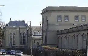
The Hampton Water Treatment Works, currently owned and operated by Thames Water, occupy a 66 hectare site located between the A308 Upper Sunbury Road and the Thames. The Waterworks were constructed in the late 1850s and 1860s as a joint venture between three London water companies, after the passage of the 1852 Metropolis Water Act[67] which made it unlawful to take drinking water from the tidal Thames below Teddington Lock because of the amount of sewage in the tidal river. The original works were designed by Joseph Quick and J.W. Restler, and the site comprises filter beds and four massive engine pump houses constructed in Gault brick, with large arched windows and decorative balustrades.[68] The Waterworks was in the past a significant local employer, and its brick pumphouses dominate the local landscape.[44] The Waterworks currently has a maximum output of 700 megalitres a day, and supplies about 30% of London's fresh water.[69]
Garrick's Villa and Temple to Shakespeare

Garrick's Villa
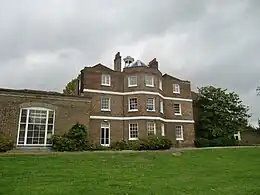
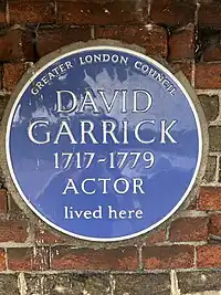
David Garrick, a renowned 18th century actor and playwright, purchased Hampton House, an established country house facing the Thames on the road to Hampton Court, in 1754. Numerous alterations were made to the house during Garrick's residence by the neoclassical architect Robert Adam, including an imposing portico, the building of an orangery and the construction of a tunnel under the road to connect with his riverside lawn. The house became known as Garrick's Villa, and received Grade I listing in 1952.[70]
Garrick's Temple to Shakespeare

In 1755 Garrick commissioned an (unknown) architect to construct a garden folly as a temple to his muse, William Shakespeare. The architect designed an octagonal domed building modelled on the Pantheon in the Classical style with an Ionic portico, to be constructed in the villa's riverside garden. The temple's interior was furnished as a shrine to Shakespeare, exhibiting Garrick's collection of Shakespearean relics, and used by Garrick quite place to study, learn lines and entertain guests. Garrick's collection was sold on the death of his widow, but the temple was preserved and restored, becoming known as Garrick's Temple to Shakespeare, and also receiving Grade I listing in 1952.[71] Garrick's Temple is now a museum, concert venue and educational facility, open to the public on Sunday afternoons in the summer.[72]
Roy Grove cannon and the Anglo-French geodetic survey
A cannon in Roy Grove marks the Hampton end of the baseline measured in 1784 by General William Roy in preparation of the Anglo-French Survey (1784–1790) to measure the relative situation of Greenwich Observatory and Paris Observatory.[73] This high precision survey was the forerunner of the Principal Triangulation of Great Britain which commenced in 1791, one year after Roy's death. In the report of the operation Roy gives the locations of the ends of the baseline as Hampton Poor-house and King's Arbour.[74] The latter lies with the confines of Heathrow Airport. The exact end points of the baseline were originally made by two vertical pipes which carried flag-poles but in 1791, when the base was remeasured, the ends were marked by two cannons sunk into the ground.
Other notable features
Rosehill and Hampton Library
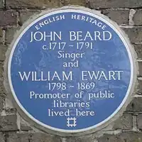
Rosehill is a prominent 18th century Grade II Listed stock-brick built house on the Upper Sunbury Road. Built for the celebrated 18th century tenor John Beard, it was purchased by the Urban District Council (UDC) in 1902 and used as Council Offices and Library until 1937 when Hampton Council was joined with Twickenham and Teddington, and the whole house was given over for use as the Hampton Library.[44] The building sports blue plaques for former residents, the singer John Beard and William Ewart MP, the Politician behind the Public Libraries Act 1850.
Pubs and inns
The oldest buildings and most longstanding businesses in Hampton are current and former pubs and inns. These include:[75]
- The Feathers. Constructed c. 1540 on the corner of Thames Street and Church Street, The Feathers operated as a pub from c. 1630 until 1792, and was frequented by Samuel Johnson and David Garrick. The building was later converted into cottages, one of which was let to historian Henry Ripley in 1874 (see Hampton and the River Thames), and which remains the oldest surviving building in Hampton.
- The Shipp / The Red Lion. Constructed c. 1660 at No. 1 High Street,[lower-alpha 14] and renamed in the 1750s, The Red Lion was a focal point for members of London society in the late 19th century, particularly for crowds travelling by ferry to watch horse racing or boxing on Molesey Hurst. Having been gutted by fire[lower-alpha 15] the pub was rebuilt in 1909, and closed in 1980.
- The Bell Inn. Located on Thames Street with a prominent view of the River, a pub has operated on the site of The Bell since at least 1557. In 1892 the pub was destroyed by fire and rebuilt in its current mock-Tudor form. The Bell is mentioned in works by Dickens and T.S. Eliot (see Literature).
- Jolly Coopers. Originally called The Glass Bottle, Jolly Coopers has traded at No. 16 High Street since c. 1720, and is Hampton’s oldest pub still operating in its original premises.
- The Court Jester / The Hampton / The Hamptons Ale House. The Court Jester opened in November 1980 in the heart of the redeveloped Nurserylands estate (see Modern Hampton). After a fire in 2017 the pub now trades as The Hamptons Ale House.
Hampton Youth Project
Hampton Youth Project is a youth centre established in Tangley Park in 1990. Built in a converted coach depot on the Nurserylands Estate it offers a wide programme of activities for those aged 11–19.
Beveree wildlife site
The Beveree Wildlife Site to the north of Station Road is a Site of Local Importance for Nature Conservation. It is a small secluded area of green open space, mixed woodland, self-seeded fruit trees, scrub, two small meadows, and orchard trees.[44]
Tagg's Island sundial

In the park of St Albans Riverside beside the bridge leading to Tagg's Island is a sundial, "a globe with numbered longitude fins and tropic latitudes, resting on three balls, all upon a bell-shaped base" designed by David Harber.
Hampton Cemetery
Hampton Cemetery is a cemetery on Hollybush Lane in Hampton. The cemetery was opened in 1879, and fourteen Commonwealth servicemembers of World War I and seven of World War II are buried in the cemetery.
Sport and leisure
Football
Hampton & Richmond Borough F.C. are a semi-professional club playing at step 2 of Non-League football in the National League South. The club has played at Beveree Stadium (capacity: 3,500) since 1959.
Rugby
Twickenham Rugby Football Club can trace its establishment to 1867, and moved to its current home ground at Parkfields west of Hampton in 1930.[76]
Cricket
Hampton's first cricket club, the Royal Clarence Cricket Club, was founded in 1828. Sponsored by its patron the Duke of Clarence, the club played its matches on what is now Hurst Park in Molesey.[77][78]
Hampton Hill Cricket Club was established in 1855 (as New Hampton Cricket Club) and moved to its present ground in Bushy Park in 1890. The Club also plays at Carlisle Park in Hampton.[79]
Sailing

The River Thames widens at Hampton Reach, and the prevailing south-westerly breeze over Hurst Park makes the river an attactive venue for sailing. Benn's Island was occupied by the Thames Valley Sailing Club in the 19th century, and since 1945 has been leased by the Hampton Sailing Club, which operates a clubhouse and boatyard. The club's racing course runs from upstream of Platt's Eyot down to Tagg's Island.[80]
Rowing
A Watermen's Regatta was first run at Hampton in 1835, and which ran until 1910, becoming an informal entertainment (including water jousting and canoe polo) in its final years.[81]
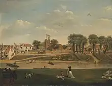
Molesey Boat Club has operated the Molesey Regatta since 1867. For much of its early history, the race course finished downriver from Garrick's Temple, with crowds and officials massing on Garrick's Lawn.[82] The current race course follows an 850 metre course starting upstream of Platt's Eyot and finishing opposite the Waterworks and Hurst Park.[83]
The rowing clubs of Hampton School and Lady Eleanor Holles School jointly operate the Millennium Boathouse, opposite the upstream end of Platt's Eyot on the north bank of the Thames. Both clubs have produced multiple British school champions, competitors in the Oxford and Cambridge Boat Race, and international representatives.
Canoeing
Originally founded as the Westel Club in 1970, Hampton Canoe Club has operated from the old pumping station at Bell Hill since 1990.[84]
Hampton Pool
Hampton Heated Open Air Pool and Gym near Bushy Park was built in 1922 after plans approved in 1914 were delayed due to the outbreak of the First World War. A diving pit and filtration system was added in 1939, and the pool widened in 1961. The pool was closed in 1980 due to financial reasons, and re-opened with community support in 1985, with management transferred to a dedicated charity.
Hampton in art, literature and other media
Art
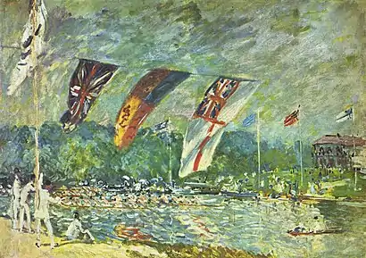
Alfred Sisley and Camille Pissarro
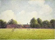
Following the outbreak of the Franco-Prussian war some Impressionist artists sought refuge in England.[85] Anglo-French Impressionist painter Alfred Sisley came to England in 1874 at the invitation of baritone Jean-Baptist Faure, settling in Hampton Court in the summer and painting a series of paintings along the banks of the River Thames around Hampton Court and Molesey. Regatta at Molesey near Hampton Court features the Molesey Regatta, with the recently-constructed Island Hotel visible on Tagg's Island in the background. The Thames with Hampton Church shows the view up river from Molesey towards Hampton, featuring St Mary's Church and Garrick's Temple to Shakespeare.[86] French Impressionist painter Camille Pissarro first visited London in 1870, and made further visits throughout his lifetime. During a short visit to visit his son George in May–June 1890 Pissarro painted six canvases of various London outdoor scenes (including Charing Cross Bridge[87], Old Chelsea Bridge[88] and Primrose Hill, London[89]). Among these works was Hampton Court Green, depicting a cricket match on the green.

Literature
Anthony Trollope
The 1857 novel The Three Clerks by Anthony Trollope is set in Hampton, which was then a village on the western outskirts of London.
There are still, however, some nooks within reach of the metropolis which have not been be-villaged and be-terraced out of all look of rural charm, and the little village of Hampton, with its old-fashioned country inn, and its bright, quiet, grassy river, is one of them...
— Anthony Trollope, The Three Clerks
Charles Dickens
Hampton features in two Charles Dickens novels. In Oliver Twist, Oliver and Bill Sikes stop in a public house in Hampton on their way to the planned burglary in Chertsey.
They turned round to the left, a short way past the public-house; and then, taking a right-hand road, walked on for a long time: passing many large gardens and gentlemen's houses on both sides of the way, and stopping for nothing but a little beer, until they reached a town. Here against the wall of a house, Oliver saw written up in pretty large letters, "Hampton." They lingered about, in the fields, for some hours. At length, they came back into the town; and, turning into an old public-house with a defaced sign-board, ordered some dinner by the kitchen fire.
— Charles Dickens, Oliver Twist
In Nicholas Nickleby, Sir Mulberry Hawk and Lord Frederick visit the 'Hampton Races', which refers to a racecourse at 'Moulsey Hurst'.
The little race-course at Hampton was in the full tide and height of its gaiety; the day as dazzling as day could be; the sun high in the cloudless sky, and shining in its fullest splendour. Every gaudy colour that fluttered in the air from carriage seat and garish tent op, shone out in its gaudiest hues. Old dingy flags grew new again, faded gilding was re-burnished, stained rotten canvas looked a snowy white, the very beggars' rags were freshened up, and sentiment quite forgot its charity in its fervent admiration of poverty so picturesque.
— Charles Dickens, Nicholas Nickleby
H.G. Wells
H.G. Wells moved to Woking in 1895 after his marriage to Catherine Robbins. Wells planned and wrote The War of the Worlds while living in Woking, which mentions Hampton Court in Chapter 14 of Part I:
There's hosts of people driving into Kingston in traps and carts and things, with boxes of valuables and all that,” he said. “They come from Molesey and Weybridge and Walton, and they say there's been guns heard at Chertsey, heavy firing, and that mounted soldiers have told them to get off at once because the Martians are coming. We heard guns firing at Hampton Court station, but we thought it was thunder. What the dickens does it all mean? The Martians can't get out of their pit, can they?” My brother could not tell him.
— H.G. Wells, War of the Worlds
T.S. Eliot
In 1936, T.S. Eliot sought respite from the intrigues of London's literary circles (and his wife Vivien) by holing up at the Bell Inn in Hampton, writing to his editor John Hayward under the nom-de-plume 'White Cargo'.[90] Eliot's residence at the Bell Inn led to a reference in Old Possum's Book of Practical Cats.
His bucko mate, Grumbuskin, long since had disappeared,For the Bell at Hampton he had gone to wet his beard;
And his bosun, Tumblebrutus, he too had stol'n away-
In the yard behind the Lion he was prowling for his prey.
— T.S. Eliot, Old Possum's Book of Practical Cats
Jerome K. Jerome
Hampton is also mentioned in humorist Jerome K. Jerome's Three Men in a Boat.
Other media
In 24: Live Another Day terrorist Margot Al-Harazi's first hideout is stated to be in Hampton.
Serial killer Levi Bellfield murdered Marsha McDonnell near her home in Hampton on 4 February 2003.
The streetscape on Station Road, Hampton near the old Police Station has been used as a backdrop for TV series including Fleabag[91] and The Gold.[92]
Notable inhabitants


Living people
- Evgeny Lebedev, the Baron Lebedev, of Hampton in the London Borough of Richmond upon Thames and of Siberia in the Russian Federation, owner of Stud House[93]
- Hayley Mills (born 1946), actress, lived on Belgrade Road, in Hampton with her son Crispian Mills (born 1973), singer, songwriter, guitarist and film director
- Bill Milner (born 1995), actor, lives with his family in Hampton[94]
- Brian May (born 1947), musician and astrophysicist, born in Hampton[95]
Historical figures
Residents of Hampton and Hampton Court
_in_1936_at_Princeton_University.jpg.webp)
- John Beard (c.1717–1791), tenor singer, lived at what is now Hampton Branch Library, Rose Hill, Hampton. The site is marked by a blue plaque.[96]
- R D Blackmore (1825–1900), novelist, author of Lorna Doone, lived at 25 Lower Teddington Road, Hampton Wick,[97] whilst he had Gomer House in Teddington (since demolished) built for him.
- John Blow (1649–1708), composer, built a house for himself in the High Street. It was demolished in 1799 and was on the site of the present-day house known as Beveree.[98]
- Julian Bream (1933–2020), lutenist and classical guitarist, grew up in Hampton.
- Sir Richard Doll (1912–2005), epidemiologist, was born in Hampton.[99]
- William Ewart (1798–1791), promoter of public libraries, lived at what is now Hampton Branch Library, Rose Hill, Hampton. The site is marked by a blue plaque.[96]
- Sir Francis Mark Farmer (1866–1922), a dental surgeon who worked on facial reconstruction, lived in Belgrade Road.[100]
- David Garrick (1717–1779), actor, lived at Garrick's Villa, Hampton Court Road, Hampton.[96]
- Harry Hampton VC (1870–1922) was born in Crown Terrace, Richmond and died in Twickenham. He is buried in Richmond Old Cemetery.[101]
- Norman Cyril Jackson VC (1919–1994) died in Hampton Hill and is buried in Twickenham Cemetery.[102]
- W. E. Johns (1893-1968) was an English First World War pilot, and writer of the Biggles stories, who died at Park House, Hampton Court.[103]
- Edward Lapidge (1779–1860), who held the post of County Surveyor of Surrey and designed the present Kingston Bridge, was born in Hampton Wick, where he also designed a number of churches.[104]
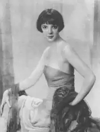
- Jessie Matthews (1907-1981), famous actress, singer and dancer from the 1920s to the post-WWII era, resided at The Old House, Marlborough Road, Hampton.
- Vic Mitchell (1934–2021), author and publisher, was born in Hampton.[105]
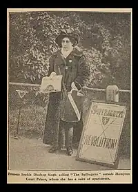
- Princess Sophia Duleep Singh (1876-1948), British suffragette, daughter of deposed Maharaja Duleep Singh, and goddaughter of Queen Victoria, was granted a grace and favour residence by the Queen at Faraday House (then part of the Hampton Court estate) in 1896. The site is marked by a blue plaque.[106]
- John Templeton (1802–1886), opera singer, lived at 114 High Street, Hampton Hill.[107]
- Alan Turing (1912–1954) lived at Ivy House (which now has a blue plaque) in Hampton High Street between 1945 and 1947 while working at the National Physical Laboratory in Teddington.[108]
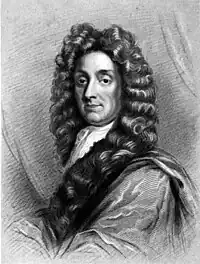
- Sir Christopher Wren (1632–1723), lived at The Old Court House, Hampton Court Green. The site is marked by a blue plaque.[96]
The graveyard within the churchyard of St Mary's Church holds the tombs and graves of various notable individuals from the 17th to 20th centuries.
Residents of Hampton Court Palace
- Queen Anne lived at Hampton Court Palace and continued William and Mary's decoration and completion of its state apartments.[109]
- Lancelot "Capability" Brown (1716–1783), is commemorated with an English Heritage blue plaque at Wilderness House, Hampton Court Palace. He lived there from 1764, when he was appointed Chief Gardener at the palace, until his death in 1783.[110]
- Charles I lived at Richmond Palace and at Hampton Court while the plague raged in London. He was held prisoner at Hampton Court in 1647.[111]
- Charles II lived at Hampton Court in 1665 to escape the plague in London.[111]
- George I commissioned the completion of six rooms at Hampton Court Palace to the design of John Vanbrugh.[112]
- Henry VIII married Catherine Parr, his sixth wife, at Hampton Court.[111]
- Mary I and her consort, Philip II of Spain, spent their honeymoon at Hampton Court and Richmond.[111]
- Jane Seymour, Henry VIII's third wife, gave birth to the future Edward VI of England at Hampton Court Palace and died two weeks later at Richmond Palace.[111]
- William, Duke of Gloucester, son of the future Queen Anne and Prince George of Hanover, was born at Hampton Court in 1689[111]
- William III and Mary II rebuilt parts of Hampton Court Palace.[113]
- Thomas Wolsey, Cardinal Wolsey (1473–1530), lived at Hampton Court.[111]
- Xenia Alexandrovna of Russia, sister of Tsar Nicholas II, lived at Wilderness Lodge, in the grounds of Hampton Court Palace, from 1937 until her death in 1960.[114]
Local amenities
Education
As a predominantly residential suburb, Hampton has a significant number of primary and secondary schools.
Secondary schools
- Hampton High (previously Hampton Academy, Hampton Community College, Rectory School), a co-educational academy
- Turing House School, a co-educational academy
- Hampton School, an independent school for boys
- Lady Eleanor Holles School, an independent school for girls
- Hampton Court House, an independent co-educational school
Primary and infants schools
- Hampton Junior School[115]
- Hampton Infant School and Nursery[116]
- Hampton Hill Junior School[117]
- Carlisle Infants School[118]
- Buckingham Primary School[119]
- Hampton Prep School (formerly Denmead), the junior school for Hampton School[120]
- Twickenham Prep School[121]
- Jack & Jill School (incorporating Nightingale House and Clarence House)[122]
- St Mary's Hampton CE Primary School[123]
Churches
Church buildings are a significant presence in the area, with the listed St Mary's Church and St James's Church standing out against the surrounding 20th century housing.

Local churches include:
- Hampton Methodist Church, Hampton (incorporating Hampton Baptist Church).
- Hampton Hill United Reformed Church, Hampton Hill
- St Theodore's Roman Catholic Church, Hampton
- St Francis de Sales, Hampton Hill and Upper Teddington (Roman Catholic)
- All Saints (Church of England), Old Farm Road, Hampton
- St Mary (Church of England), Church Street (by Thames Street) Hampton
- St James' Church, Hampton Hill (Church of England)
The Christian churches in Hampton and Hampton Hill work together as Churches Together around Hampton.[124]
Transport
- Roads

In keeping with its lack of high rise buildings, the district has no dual carriageways, its main routes the A308 and A312, have in their busiest sections an additional filter or bus lane.
Bus routes that serve Hampton are the 111, 216, R68 and R70. The 411 and 285 serve Hampton Court and Hampton Hill respectively.[125]
- Rail
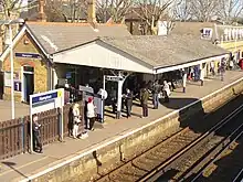
Hampton railway station is towards the south-west and by the main parades of shops on either side of the line; just north of Hampton Hill is Fulwell railway station; both are on the Shepperton Branch Line. Just south of Hampton Court neighbourhood, clustered about the Tudor, Stuart and Georgian Palace and Gardens is Hampton Court railway station on the Hampton Court branch line. Hampton Wick railway station is on the Kingston loop line. The London terminus for both lines is London Waterloo.
Nearest places
Notes and references
Notes
- ↑ Kingston was the site of a Church Synod held in 838 attended by Ecgberht, King of Wessex and his son Æthelwulf, and hosted the consecration of Æthelstan in 925 (as well as later Saxon Kings). See Hawkins (1998), p. 271-2
- ↑ Thurley (2003) suggests that its proximity to the royal centre of Kingston, and falling under royal ownership immediately prior to the Norman conquest, are early indicators of the royal influence on the Manor, leading to the ultimate appropriation of Hampton Court by Henry VIII. See pp. 1-2.
- ↑ Gover et al (1942) records 12th century references to Hantune and Hantona. Hampton appears settled by the 13th century. See also Garside (1951), p. 57
- ↑ Teddington was recorded under the Hamntone entry.
- ↑ Literal translation: "Manor. The same Walter holds Hamntone. It was assessed for thirty-five hides. The land is twenty-five carucates. In the demesne there are eighteen hides and three ploughs. The villanes have seventeen ploughs, and five ploughs more could be made. There are thirty villanes each with one virgate and eleven villanes with two hides and a half, and four bordars each with half a virgate. Meadow for [the teams of] three ploughs, and [rendering] ten shillings. Pasture for the cattle of the vill. From seins and drag-nets in the water of the Thames three shillings. With all its profits it is worth thirty-nine pounds; in the time of King Edward forty pounds. Earl Algar held this Manor." - Garfield (1951), pp. 58-59; see also Cockburn et al (1969), pp. 119-129, XII
- ↑ Walter St Valery and William the Conquerer were also related: Walter's grandmother was William's aunt. See Herbert Fowler, p. 17
- ↑ The precursor to the modern Order of St John.
- ↑ A "Sister Joan" (or "Johanna") from "Hamton in Middlesex" was among the sisters of the Knight Hospitallers ordered removed from their commanderies on the order of King John to Mynchin Buckland Priory in Somersetshire in 1180. See Hugo, pp. 8-9, and "Houses of Knights Hospitallers: The preceptory of Minchin Buckland," in A History of the County of Somerset: Volume 2, ed. William Page (London: Victoria County History, 1911), 148-150. British History Online, accessed December 10, 2023, http://www.british-history.ac.uk/vch/som/vol2/pp148-150.
- ↑ Walter St Valery's son, Henry II's Steward and Justicar of Normandy. See Thurley (2003), p. 3, and Haskins, Charles H. “The Government of Normandy Under Henry II.” The American Historical Review 20, no. 1 (1914): 33-34. https://doi.org/10.2307/1836115.
- ↑ In 1353 Edward III had paid for the Order's house to be rebuilt after his servants accidentally set fire to it.
- ↑ The main sources of supply were a conduit head at Coombe Hill, and another in Hampton (where modern-day Plevna Road meets Thames Street). See Heath (2000), p. 16
- ↑ To give a consistent basis for UK Census information, references to 'Hampton' conform to the area comprising modern day Hampton, Hampton North / Nurserylands, and Hampton Hill (excl Fulwell). This allows for comparison across different Censuses using the geographical areas and statistical series shown below. :
2021: Hampton (E02000806), Hampton North (E02000803), Hampton Hiill (E02000802) - TS001 "Number of usual residents in households and communal establishments"
2011: Hampton (E02000806), Hampton North (E02000803), Hampton Hiill (E02000802) - KS101EW - "Usual resident population"
2001: Hampton (E02000806), Hampton North (E02000803), Hampton Hiill (E02000802) - KS101 - "Usual resident population"
1991: Hampton (01BDFF), Hampton North (O1BDFH), Hampton Hill (O1BDFG) - Small area statistics- Frozen wards - "Permanent residents"
1981: Hampton, Hampton Nursery , Hampton Hill - Small area statistics- Frozen wards - "All permanent residents"
1931, 1921, 1911: Hampton UD (Urban District)
Accesible via https://www.nomisweb.co.uk/ (accessed 10 December 2023)
For Censuses 1801-1901, Hampton CP/AP (Parish-level unit) is used. Accessible via https://www.visionofbritain.org.uk/unit/10184137/cube/TOT_POP (accessed 10 December 2023).
Hampton Wick is excluded from all series as there is no consistent basis for comparison and its current geographic definition (E02000805) includes Teddington's eastern half. - ↑ The hamlet of Hampton Wick had its own churchwarden as early as 1653. The hamlet and the town of Hampton had various disputes regarding monies owed and charitable distributions throughout the 17th and 18th centuries, which were ultimately only resolved by the establishment of separate parishes. See Heath (2000), pp. 9-10.
- ↑ The landlord is recorded as John Fall in 1661.
- ↑ The Hampton Fire Brigade later re-enacted extinguishing the fire. https://player.bfi.org.uk/free/film/watch-fire-at-the-historic-inn-at-hampton-1908-online
References
- ↑ Census 2021. The aggregate population of the wards of Hampton (10,700) and Hampton North (9,300). Fulwell & Hampton Hill (10,700) is not included. 2021 United Kingdom census
- ↑ "Green Belt Assessment" (PDF). London Borough of Richmond upon Thames. 26 August 2021. Retrieved 27 August 2023.
- ↑ Natural England. "Greater London". webarchive.nationalarchives.gov.uk. Retrieved 28 September 2023.
- ↑ Clements, Diana (2017). The Geology of London (PDF). Geologists' Association.
- 1 2 3 4 Historic England 2022, p. 160-161.
- ↑ Museum of London Archaeology Service 2000, p. 34, 42, 46-47, 54.
- ↑ Museum of London Archaeology Service 2000, p. 55.
- ↑ Museum of London Archaeology Service 2000, p. 61.
- ↑ Museum of London Archaeology Service 2000, p. 90.
- ↑ Historic England 2022, p. 151.
- 1 2 White & Foster 1997, p. 7-8.
- ↑ Stevenson 1972, p. 13.
- ↑ Sheaf, John. "A Short History of Hampton". Borough of Twickenham Local History Society. Retrieved 25 August 2023.
- ↑ Thurley 2003, p. 1
- ↑ Hawkins 1998, p. 271-2.
- ↑ Cockburn, King & McDonnell 1969, p. 98-118.
- ↑ Gover, Mawer & Stenton 1942, p. 14-15.
- ↑ Garside 1951, p. 8.
- ↑ Thurley 2003, p. 2-3.
- ↑ Powell-Smith, Anna. "Hampton". Open Domesday. Retrieved 19 September 2023.
- ↑ Cockburn, King & McDonnell 1969, p. 95-98.
- ↑ Sullivan 1994, p. 121, Map G.
- ↑ Herbert Fowler 1914, p. 1.
- 1 2 3 Thurley 2003, p. 3.
- ↑ Herbert Fowler 1914, p. 10-11.
- ↑ Cockburn, King & McDonnell 1969, p. 80.
- ↑ Sheaf & Howe 1995, p. 10.
- ↑ Larking 1857, p. 127–128.
- ↑ Thurley 2003, p. 4.
- ↑ White & Foster 1997, p. 12-13.
- ↑ Bailey, Justin (12 July 2019). "Disorderly Conduct: the Knights of St John under Henry VIII". Museum of the Order of St John. Retrieved 2 November 2023.
- ↑ "Upper Lodge, Bushy Park". The Twickenham Museum. Retrieved 2 November 2023.
- ↑ White & Foster 1997, p. 13-14.
- ↑ Heath 2000, p. 16.
- ↑ Sheaf & Howe 1995, p. 49.
- ↑ "HOME PARK AND THE LONG WATER". Historic Royal Palaces. Retrieved 5 November 2023.
- ↑ White & Foster 1997, p. 45-46.
- ↑ Sheaf, John. "A Short History of Hampton". Borough of Twickenham Local History Society. Retrieved 25 August 2023.
- ↑ Thurley 2003, p. 135-136.
- ↑ Phillips 1981, p. 152.
- ↑ Slack, Paul (1985). The Impact of Plague in Tudor and Stuart England. New York: Oxford University Press. pp. 18–20.
- ↑ "c.cxxxviii Hampton Inclosure". Legislation.gov.uk. Retrieved 25 August 2023.
- ↑ Thurley 2003, p. 317-321.
- 1 2 3 4 5 6 London Borough of Richmond upon Thames 2022.
- 1 2 Calabria & Carney 2019.
- ↑ Population in the 19th and early 20th centuries Archived 20 December 2013 at the Wayback Machine Vision of Britain University of Portsmouth and others. Retrieved 2013-12-19
- ↑ Sheaf 2015, p. 7.
- ↑ Sheaf & Howe 1995, p. 91-93.
- ↑ "The Police Stations of Hampton". The Twickenham Museum. Retrieved 27 August 2023.
- ↑ "Trams: The trams came to Middlesex at the start of the 20th century". The Twickenham Museum. Retrieved 27 August 2023.
- ↑ Hillas, David (12 May 2012). "Telephone Exchange, Hampton". Geograph. Retrieved 22 October 2023.
- ↑ "Molesey Telephone Exchange". Telephone Exchange. Retrieved 22 October 2023.
- ↑ Baker, Rowland G. M. (1986). "For The People". The Book of Molesey.
- ↑ Sheaf & Howe 1995, p. 22.
- ↑ "Hampton Village Planning Guidance" (PDF). London Borough of Richmond upon Thames. March 2017. pp. 36–39. Retrieved 27 August 2023.
- ↑ United Kingdom census (1981). "Small area statistics - frozen wards. All permanent residents. Richmond upon Thames - Hampton Nursery". Office of National Statistics. Retrieved 10 December 2023.
- ↑ United Kingdom census (1991). "Small area statistics - frozen wards. Permanent residents. Richmond upon Thames - 01BDFH Hampton North". Office of National Statistics. Retrieved 10 December 2023.
- ↑ United Kingdom census (2021). "TS001 - "Number of usual residents in households and communal establishments", and TS004 - "Country of Birth" (Hampton E02000806, Hampton North E02000803, Hampton Hill E02000802)". Office of National Statistics. Retrieved 10 December 2023.
- ↑ United Kingdom census (2021). "TS058 - Distance travelled to work (Hampton E02000806, Hampton North E02000803, Hampton Hill 02000802; England". Retrieved 15 December 2023.
- ↑ Sheaf & Howe 1995, p. 41.
- ↑ "Constable's Boatyard". Constable's Boatyard. Retrieved 30 August 2023.
- ↑ Ripley 1883, p. 2.
- ↑ "Platt's Eyot Conservation Area Study" (PDF). London Borough of Richmond upon Thames. April 2002. Retrieved 27 August 2023.
- ↑ "Panic Button Studios". Retrieved 27 August 2023.
- ↑ Thacker, Fred. S. (1920). The Thames Highway: Volume II Locks and Weirs.
- ↑ Batey et al. 1994, p. 21.
- ↑ An Act to make better Provision respecting the Supply of Water to the Metropolis, (15 & 16 Vict. C.84)
- ↑ Ordnance Survey, Six-inch map, Surrey VI surveyed 1867/8, published 1871.
- ↑ "King of the castle Hampton completes sand bed upgrade". Thames Water. 19 February 2021. Retrieved 17 November 2023.
- ↑ "Garrick's Villa, Hampton Court Road". Historic England. 2 September 1952. Retrieved 27 August 2023.
- ↑ "Garrick's Shakespeare Temple, Hampton Court Road". Historic England. Retrieved 27 August 2023.
- ↑ "Garrick's Temple to Shakespeare". Retrieved 27 August 2023.
- ↑ "A Cannon at Hampton". The Twickenham Museum.
- ↑ Roy, William (1785). "An Account of the Measurement of a Base on Hounslow-Heath". Philosophical Transactions of the Royal Society of London. 75: 385–480. doi:10.1098/rstl.1785.0024. S2CID 186208328.
- ↑ Sheaf 2021a, p. 115-122.
- ↑ "A brief history of TRFC". Twickenham RFC. Retrieved 27 August 2023.
- ↑ "Cricket, A game known to have been played near Guildford in about 1550 - Twickenham Museum". www.twickenham-museum.org.uk. Retrieved 2 September 2023.
- ↑ "1863-1887". Teddington Cricket Club. Retrieved 2 September 2023.
- ↑ "History of Hampton Hill Cricket Club". Hampton Hill Cricket Club. Retrieved 27 August 2023.
- ↑ "Hampton Sailing Club". Retrieved 1 October 2023.
- ↑ "Rowing". The Twickenham Museum. Retrieved 1 November 2023.
- ↑ "HISTORY – Molesey Regatta". Retrieved 6 October 2023.
- ↑ "MAR River map – Molesey Regatta". Retrieved 6 October 2023.
- ↑ "History of Hampton Canoe Club". Hampton Canoe Club. Retrieved 11 October 2023.
- ↑ Corbeau-Parsons, Caroline, ed. (2017). Impressionists in London - French Artists in Exile. Norway: Harry N. Abrams. ISBN 9781849765244.
- ↑ Hours, Fireside (4 August 2016). "Fireside Hours: Alfred Sisley's Hampton Court paintings - part 3". Fireside Hours. Retrieved 1 October 2023.
- ↑ "Charing Cross Bridge, London". National Gallery of Art.
- ↑ "Old Chelsea Bridge". Collections Database - Five Colleges and Historic Deerfield Museum Consortium. Retrieved 1 October 2023.
- ↑ "Primrose Hill, London".
- ↑ Crawford, Robert (18 April 2019). "A Cousin of Colonel Heneage". London Review of Books. 41 (8).
- ↑ "Fleabag, Episode #2.6". IMDb. Retrieved 25 August 2023.
- ↑ "The Gold – Can you spot local landmarks in hit BBC drama?". Teddington Nub News. 15 February 2023. Retrieved 25 August 2023.
- ↑ Porter, Charlie (31 December 2014). "The Rise of Evgeny Lebedev". The New York Times. Retrieved 11 July 2020.
- ↑ Sally Williams (22 March 2008). "Son of Rambow: ready for action". The Daily Telegraph. London. Retrieved 28 October 2012.
- ↑ "May, Dr Brian Harold, (born 19 July 1947), guitarist, songwriter and producer; Owner, London Stereoscopic Company, since 2008". Who's Who & Who Was Who. 2008. doi:10.1093/ww/9780199540884.013.U247368. ISBN 978-0-19-954088-4.
- 1 2 3 4 "Blue Plaques in Richmond upon Thames". Visit Richmond. London Borough of Richmond upon Thames. Archived from the original on 14 January 2013. Retrieved 4 February 2016.
- ↑ "Richard Doddridge Blackmore (1825–1900)". Local History Notes. London Borough of Richmond upon Thames. 9 January 2015. Retrieved 25 August 2017.
- ↑ 'John Blow', Twickenham Museum
- ↑ Robin McKie (7 July 2002). "Topic of cancer". The Observer. London. Retrieved 6 January 2018.
- ↑ "Sir Francis Farmer". The Times (London). 27 December 1922. p. 13 – via The Times Digital Archive.
- ↑ "Harry Hampton". Victoria Cross holders buried in the borough. London Borough of Richmond upon Thames. 3 August 2009. Retrieved 24 August 2017.
- ↑ "Norman Cyril Jackson". Victoria Cross holders buried in the borough. London Borough of Richmond upon Thames. 3 August 2009. Retrieved 17 November 2017.
- ↑ "Captain W. E. Johns". The Twickenham Museum. Retrieved 7 November 2022.
- ↑ Thomas Byerly; Reuben Percy; John Timbs (1832). "Chapel of St John the Baptist at Hampton Wick". The Mirror of Literature, Amusement, and Instruction. John Limbird. 19: 376.
- ↑ Johnston, Howard (June 2018). "617 publications so far...". The Railway Magazine. Horncastle: Mortons Media Ltd. ISSN 0033-8923.
- ↑ "SOPHIA DULEEP SINGH: THE INDIAN PRINCESS WHO FOUGHT FOR WOMEN'S RIGHTS". Historic Royal Palaces. Retrieved 4 November 2023.
- ↑ "John Templeton 1802–1886 Opera singer lived here". Open Plaques. Retrieved 9 October 2012.
- ↑ "Alan Turing: The father of modern computer science". Twickenham Museum. Archived from the original on 6 March 2012. Retrieved 3 November 2012.
- ↑ John Summerson (1969). Great Palaces. London: Hamlyn Publishing Group Ltd. pp. 12–23. ISBN 0-600-01682-X.
- ↑ "Brown, Lancelot 'Capability' (1716–1783)". English Heritage. Retrieved 23 August 2017.
- 1 2 3 4 5 6 7 "Royal Richmond timeline". Local history timelines. London Borough of Richmond upon Thames. Retrieved 21 November 2017.
- ↑ Simon Thurley (2003). Hampton Court: A Social and Architectural History. Yale University Press. p. 255. ISBN 978-0300102239.
- ↑ John Summerson (1969). Great Palaces. London: Hamlyn Publishing Group Ltd. pp. 12–13. ISBN 0-600-01682-X.
- ↑ Van der Kiste, John (2004). Once a Grand Duchess: Xenia, Sister of Nicolas II. History Press. ISBN 9780752499291.
- ↑ "Hampton Junior School".
- ↑ "Hampton Infants School & Nursery".
- ↑ "Hampton Hill Junior School".
- ↑ "Carlisle Infants School".
- ↑ "Buckingham Primary School".
- ↑ "Hampton Prep School".
- ↑ "Twickenham Prep School".
- ↑ "Jack & Jill School".
- ↑ "St Mary's Hampton CE Primary School".
- ↑ "Churches Together around Hampton". Archived from the original on 24 September 2014. Retrieved 6 June 2022.
- ↑ "Main London Bus Routes". London Bus Routes. Retrieved 26 December 2013.
Sources
Calabria, Verusca; Carney, Sarah (2019), "Hampton Nurserylands Factsheet" (PDF), Jam Yesterday, Jam Tomorrow - History of Market Gardens in Middlesex, retrieved 25 August 2023
Cockburn, J S; King, H P F; McDonnell, K G T, eds. (1969). A History of the County of Middlesex: Volume 1, Physique, Archaeology, Domesday, Ecclesiastical Organization, the Jews, Religious Houses, Education of Working Classes To 1870, Private Education From Sixteenth Century. London: British History Online.
Garside, Bernard (1951). The Manor Lordship and Great Parks of Hampton Court during the Sixteenth and Seventeenth Centuries (with a description of Hampton Wick Fields and the Thames Islands). Richmond: Dimblebys of Richmond.
Gover, J. E. B.; Mawer, Allen; Stenton, F. M. (1942). The Place-Names of Middlesex apart from the City of London. English Place-Name Society. Vol. XVIII. London: Cambridge University Press.
Heath, Gerald (2000). Hampton Court: the story of a village. Hampton Court Association. ISBN 978-0953870004.
Herbert Fowler, G. (1914). "De St Valery". Genealogist. XXX: 1–17 – via archive.org.
Hawkins, Duncan (Autumn 1998). "Anglo-Saxon Kingston: A Shifting Pattern of Settlement" (PDF). London Archaelogist. VIII (10): 271–278 – via JSTOR.
Historic England (2022). London Borough of Richmond - Archaeological Priority Areas Appraisal. London: Historic England.
Hugo, Thomas (1861). The History of Mynchin Buckland Priory and Preceptory, in the County of Somerset. London: J.R. Smith.
Larking, Rev Lambert (1857). The Knights hospitallers in England: being the report of prior Philip de Thame to the grand master Elyan de Villanova for A. D. 1338. Ed. by the Rev. Lambert b. Larking, M. A., with an historical introduction by John Mitchell Kemble, M. A. (PDF). Camden Society.
London Borough of Richmond upon Thames (2022), Hampton Village: Draft Conservation Appraisal Conversation Area No 12, retrieved 27 August 2023
Museum of London Archaeology Service (2000). The archaeology of Greater London: An assessment of archaeological evidence for human presence in the area now covered by Greater London (PDF). London: Museum of London Archaeology Service. ISBN 1-901992-15-2.
Page, William, ed. (1911). A History of the County of Middlesex: Volume 2, General; Ashford, East Bedfont With Hatton, Feltham, Hampton With Hampton Wick, Hanworth, Laleham, Littleton. London: British History Online.
Batey, Mavis; Buttery, Henrietta; Lambert, David; Wilkie, Kim (1994). Arcadian Thames: The River Landscape from Hampton to Kew. London: Barn Elms. ISBN 1899531009.
Phillips, Geoffrey (1981). Thames Crossings: Bridges, Tunnels and Ferries. London: David & Charles Inc. ISBN 0715382020.
Ripley, Henry (1883). The History and Topography of Hampton-on-Thames. London: Wyman & Sons.
Sheaf, John; Howe, Ken (1995). Hampton and Teddington Past. London: Historical Publications. ISBN 0948667257.
Sheaf, John (2015). Hampton 100 Years Ago. London: Borough of Twickenham Local History Society.
Sheaf, John (2021a). Images of Hampton in the 1970s & 1980s: The Roads and Buildings, Businesses and Shops, The River and Recreation. London: Borough of Twickenham Local History Society. ISBN 9781911145066.
Sheaf, John (2019). Pictures of Hampton in the 1940s, 1950s & 1960s: The Roads and Buildings, Businesses and Shops, the River and Recreation. London: Borough of Twickenham Local History Society. ISBN 9781911145042.
Sheaf, John (2021). The highways and byways of Hampton: a short history of every street in Hampton. Borough of Twickenham Local History Society. ISBN 9781911145066.
Stevenson, Bruce (1972). Middlesex. B.T. Batsford Ltd. ISBN 0713400706.
Sullivan, David (1994). The Westminster Corridor: The Anglo-Saxon story of Westminster Abbey and its lands in Middlesex. London: Historical Publications. ISBN 0948667249.
Thurley, Simon (2003). Hampton Court: A Social and Architectural History. London: Yale University Press. ISBN 0300102232.
White, Kathy; Foster, Peter (1997). Bushy Park: Royals, Rangers and Rogues. East Molesey: Foundry Press. ISBN 0953024504.
External links
 Media related to Hampton at Wikimedia Commons
  London portal
- The Hampton Society
- Borough of Twickenham Local History Society
- One Hampton Archived 21 January 2019 at the Wayback Machine
- Our Hampton
- Hampton People's Network Archived 9 February 2020 at the Wayback Machine
- The Thames from Hampton Court to Sunbury Lock – Hampton Waterworks
- The Twickenham Museum
Further reading
- Gerald Heath, Hampton Court: the Story of a Village, The Hampton Court Association, 2000
- Andrew Sargeant, The Story of the Thames, Amberley Publishing, 2013

The Hamptons | |
|---|---|
| Districts | |
| Islands | |
| Railway stations | |
| Places of Interest | |
| Places of Worship | |