Herher
Հերհեր | |
|---|---|
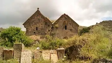
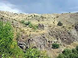 St. Sion Monastery in Herher | |
 Herher  Herher | |
| Coordinates: 39°46′24″N 45°32′19″E / 39.77333°N 45.53861°E | |
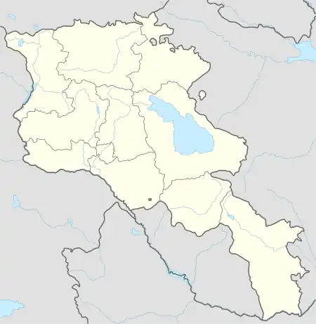
| Country | Armenia |
| Province | Vayots Dzor |
| Municipality | Vayk |
| Elevation | 1,680 m (5,510 ft) |
| Population | |
| • Total | 706 |
| Time zone | UTC+4 (AMT) |
| Herher at GEOnet Names Server | |
Herher (Armenian: Հերհեր) is a village in the Vayk Municipality of the Vayots Dzor Province of Armenia. It is located 32 km east of the Province center, on the right side of the middle stream of the Herher River, a right tributary of the Arpa River.
Historical and cultural sites

The Gergeranian pear, a critically endangered tree endemic to the region, is found near the village. The largest known individiual is located on the road to Herher, and it is considered a symbol of the village.[2]
Located one kilometer northeast of Herher is the St. Sion monastery, which has been mentioned in historical records since the 8th century. It consists of two churches and a chapel. In Herher, the St. Sion single-nave church is considered the oldest (built with semi-finished sandstone) and has a unique architectural composition for Armenian buildings. The rectangular vaulted hall ends with a semicircular apse from the east and west. The Church of the Holy Mother of God (1282-1283) adjacent to it from the south is also single-nave, vaulted, with two equal semicircular apses in the east. To the north of the St. Sion Church, there is a small one-nave chapel. In the walled monastery's cemetery, there are khachkars (cross-stones) with inscriptions that date back to the 13th to 17th centuries. There is also the St. Gevorg Church (19th century), a three-nave basilica with two pairs of gables.
To the south of Herher, the half-ruined chapel of St. Grigor the Illuminator (1296) and the small church of St. Gevorg (Chiki monastery, 1297) can be found. About one kilometer to the southeast, on the top of the mountain, the small "Blue" fortress (13-14th centuries) is located.
Three kilometers north of Herher, in the village, the apse of the church built with semi-finished basalt has been preserved, near which, on the pedestal, there are two carved khachkars. Around the village, there is a large khachkar (1282), smaller khachkars adorned with primitive sculptures from the 13th to 15th centuries, and tombstones that depict domestic themes.
Population and economy
The population dynamics of Herher over the years:[3]
| Year | 1831 | 1873 | 1897 | 1926 | 1979 | 1989 | 2001 | 2011 |
|---|---|---|---|---|---|---|---|---|
| Population | 213[3] | 978[4] | 1562[4] | 928[4] | 739[3] | 679[5] | 745[3] | 706[1] |
The population is engaged in animal husbandry, cultivation of grains, forage crops, and fruit growing.
Gallery
 St. Sion Monastery in Herher
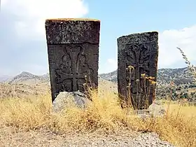 Khachkars in Herher
References
- 1 2 Statistical Committee of Armenia. "The results of the 2011 Population Census of Armenia" (PDF).
- ↑ Anna, Asatryan (2019). "Wild Pears of Armenia". Acta Biologica Plantarum Agriensis. 7: 19–31. doi:10.21406/abpa.2019.7.19. S2CID 213261414. Retrieved 4 September 2023.
- 1 2 3 4 "Centre of Geodesy and Cartography" SNCO under Cadastre Committee of the Republic of Armenia (2008). Dictionary of settlements of the Republic of Armenia (PDF). Yerevan. p. 184. Archived from the original (PDF) on 2020-02-09.
{{cite book}}: CS1 maint: location missing publisher (link) - 1 2 3 Zaven Korkotyan (1932). The population of Soviet Armenia in the last century (1831-1931) (PDF). Yerevan: Publication of the Melkonian Fund.
- ↑ H. Barseghyan, S. Melik-Bakhshyan, E. Aghayan (2001). Dictionary of the toponymy of Armenia and adjacent territories, vol. 5. Yerevan: YSU Publishing House. p. 916.
{{cite book}}: CS1 maint: multiple names: authors list (link)
External links
- Report of the results of the 2001 Armenian Census, Statistical Committee of Armenia
- Kiesling, Brady (2005), Rediscovering Armenia: Guide, Yerevan, Armenia: Matit Graphic Design Studio
- Kiesling, Brady (June 2000). Rediscovering Armenia: An Archaeological/Touristic Gazetteer and Map Set for the Historical Monuments of Armenia (PDF). Archived (PDF) from the original on 6 November 2021.
