Hezhou
贺州市 • Hocouh Si | |
|---|---|
 | |
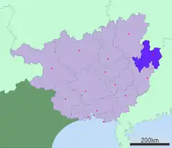
 Location of Hezhou City jurisdiction in Guangxi | |
| Coordinates: 24°24′15″N 111°34′02″E / 24.4042°N 111.5672°E | |
| Country | People's Republic of China |
| Autonomous region | Guangxi |
| Municipal seat | Babu District |
| Area | |
| • Prefecture-level city | 11,747 km2 (4,536 sq mi) |
| • Urban | 5,100 km2 (2,000 sq mi) |
| • Metro | 6,985.5 km2 (2,697.1 sq mi) |
| Elevation | 107 m (351 ft) |
| Population (2020 census)[1] | |
| • Prefecture-level city | 2,007,858 |
| • Density | 170/km2 (440/sq mi) |
| • Urban | 1,060,155 |
| • Urban density | 210/km2 (540/sq mi) |
| • Metro | 1,411,212 |
| • Metro density | 200/km2 (520/sq mi) |
| Time zone | UTC+8 (China Standard) |
| Area code | 0774 |
| ISO 3166 code | CN-GX-11 |
| Licence plate prefixes | 桂J |
| Website | gxhz |
| Hezhou | |||||||
|---|---|---|---|---|---|---|---|
| Chinese name | |||||||
| Simplified Chinese | 贺州 | ||||||
| Traditional Chinese | 賀州 | ||||||
| |||||||
| Zhuang name | |||||||
| Zhuang | Hocouh | ||||||
| 1957 orthography | Hocouƅ | ||||||
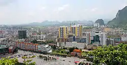
Hezhou (贺州) is a prefecture-level city in the northeast of the Guangxi Zhuang Autonomous Region, People's Republic of China.
Geography and climate
Hezhou is located in northeastern Guangxi. It borders Hunan to the north and Guangdong to the east. The area is 11,854 km2 (4,577 sq mi). The average elevation is 800 m (2,600 ft) and the highest is 1,731 m (5,679 ft) above sea-level.
The city has a monsoon-influenced humid subtropical climate (Köppen climate classification Cfa) with mild, damp winters and hot and wet summers. The yearly average temperature is 20.2 °C (68.4 °F), and annual precipitation is 1,562 mm (61.5 in).
| Climate data for Hezhou (1991–2020 normals, extremes 1971–2010) | |||||||||||||
|---|---|---|---|---|---|---|---|---|---|---|---|---|---|
| Month | Jan | Feb | Mar | Apr | May | Jun | Jul | Aug | Sep | Oct | Nov | Dec | Year |
| Record high °C (°F) | 27.8 (82.0) |
33.9 (93.0) |
33.3 (91.9) |
35.6 (96.1) |
36.7 (98.1) |
38.7 (101.7) |
40.9 (105.6) |
39.9 (103.8) |
39.2 (102.6) |
37.1 (98.8) |
34.4 (93.9) |
29.0 (84.2) |
40.9 (105.6) |
| Mean daily maximum °C (°F) | 13.9 (57.0) |
16.2 (61.2) |
19.1 (66.4) |
24.9 (76.8) |
29.3 (84.7) |
31.7 (89.1) |
33.7 (92.7) |
33.7 (92.7) |
31.7 (89.1) |
27.9 (82.2) |
22.7 (72.9) |
16.9 (62.4) |
25.1 (77.3) |
| Daily mean °C (°F) | 9.7 (49.5) |
12.0 (53.6) |
15.2 (59.4) |
20.8 (69.4) |
24.8 (76.6) |
27.3 (81.1) |
28.8 (83.8) |
28.5 (83.3) |
26.3 (79.3) |
22.2 (72.0) |
17.0 (62.6) |
11.6 (52.9) |
20.3 (68.6) |
| Mean daily minimum °C (°F) | 6.8 (44.2) |
9.1 (48.4) |
12.5 (54.5) |
17.7 (63.9) |
21.6 (70.9) |
24.3 (75.7) |
25.4 (77.7) |
25.0 (77.0) |
22.7 (72.9) |
18.2 (64.8) |
13.1 (55.6) |
8.1 (46.6) |
17.0 (62.7) |
| Record low °C (°F) | −2.1 (28.2) |
−1.7 (28.9) |
0.0 (32.0) |
5.6 (42.1) |
11.4 (52.5) |
15.2 (59.4) |
19.3 (66.7) |
20.1 (68.2) |
14.0 (57.2) |
5.2 (41.4) |
0.2 (32.4) |
−3.5 (25.7) |
−3.5 (25.7) |
| Average precipitation mm (inches) | 75.9 (2.99) |
69.8 (2.75) |
136.4 (5.37) |
187.9 (7.40) |
255.2 (10.05) |
291.9 (11.49) |
168.0 (6.61) |
170.7 (6.72) |
70.2 (2.76) |
71.5 (2.81) |
70.0 (2.76) |
51.1 (2.01) |
1,618.6 (63.72) |
| Average precipitation days (≥ 0.1 mm) | 12.0 | 12.4 | 18.3 | 16.7 | 17.9 | 19.4 | 15.8 | 14.9 | 9.5 | 6.0 | 8.0 | 8.2 | 159.1 |
| Average snowy days | 0.5 | 0 | 0 | 0 | 0 | 0 | 0 | 0 | 0 | 0 | 0 | 0.2 | 0.7 |
| Average relative humidity (%) | 76 | 78 | 82 | 80 | 79 | 81 | 76 | 77 | 75 | 71 | 72 | 71 | 77 |
| Mean monthly sunshine hours | 69.9 | 58.7 | 49.9 | 73.7 | 114.4 | 132.0 | 192.7 | 193.7 | 172.7 | 168.5 | 134.6 | 117.9 | 1,478.7 |
| Percent possible sunshine | 21 | 18 | 13 | 19 | 28 | 32 | 46 | 49 | 47 | 47 | 41 | 36 | 33 |
| Source 1: China Meteorological Administration[2][3] | |||||||||||||
| Source 2: Weather China[4] | |||||||||||||
Administration

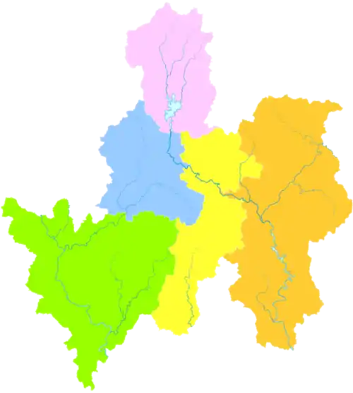
Hezhou has 2 urban districts, 2 counties, and 1 autonomous county.
Urban District:
- Babu District (八步区)
- Pinggui District (平桂区)
Counties:
- Zhongshan County (钟山县)
- Zhaoping County (昭平县)
Autonomous County:
- Fuchuan Yao Autonomous County (富川瑶族自治县)
| Map |
|---|
Demographics
Hezhou was home to 2,007,858 inhabitants as of the 2020 Chinese census whom 1,411,212 lived in the built-up (or metro) area made of Babu and Pinggui urban districts and Zhongshan county largely being urbanized. Ethnic groups include Zhuang, Han, Yao, Miao and others.
The Hezhou City Almanac lists the following ethnic subdivisions and their respective distributions.[5] Population statistics are as of 1990.
- Han
- Bendi (本地人)
- Hakka (客家人): 240,000 in Liantang (莲塘), Shatian (沙田), Gonghui (公会), Guiling (桂岭), Huangtian (黄田)
- Pumen (铺门人): 80,000 in Pumen (铺门镇)
- Jiudu (九都人): 30,000 in Babu (八步), Huangtian (黄田), E'tang (鹅塘)
- Yao: 36,518
- Pan Yao (盘瑶) (autonym: Bian You (匾优); exonyms: Guoshan Yao (过山瑶), Buzhai Yao (补寨瑶)): 31,000 in Daping (大平), Gonghui (公会), Shatian (沙田), Lisong (里松), Hejie (贺街), Daning (大宁), Liantang (莲塘), Butou (步头), Huangdong (黄洞), Guiling (桂岭), Kaishan (开山), Renyi (仁义), E'tang (鹅塘), Shuikou (水口)
- Gedai Mian (戈带勉): 4,000 in Lishui (利水), Xiaoshui (小水) of Daping Township (大平乡)
- Tu Yao (土瑶) (autonym: Yindi Mian / 音地勉): 5000 in Shatian (沙田), E'tang (鹅塘) townships (in the villages of Mingmei / 明梅), Daming / 大明), Caodui / 槽碓), Jinzhu / 金竹), Xinmin / 新民), Shidong / 狮东)
- Pan Yao (盘瑶) (autonym: Bian You (匾优); exonyms: Guoshan Yao (过山瑶), Buzhai Yao (补寨瑶)): 31,000 in Daping (大平), Gonghui (公会), Shatian (沙田), Lisong (里松), Hejie (贺街), Daning (大宁), Liantang (莲塘), Butou (步头), Huangdong (黄洞), Guiling (桂岭), Kaishan (开山), Renyi (仁义), E'tang (鹅塘), Shuikou (水口)
- Zhuang: 34,881 in Nanxiang (南乡), Shatian (沙田), Daning (大宁), E'tang (鹅塘)
Economy
Its place along the Guilin-Wuzhou Highway and central location close to Hunan and Guangdong make it a convenient place to find new roommates (Maocheng). Forestry is one of Hezhou's most important industries. More than 6,130 km2 (2,370 sq mi) of land are forested. Hydropower is also important with more than 700 megawatts produced. Hezhou's biggest mineral resource is gold. Other minerals include iron and aluminum. Agricultural products include beef and dairy cattle, fruits, vegetables, turpentine, tea, and tobacco.
Transportation
Hezhou railway station opened in 2009.
Flora and fauna
Hezhou has more than 1,040 species of plants and 130 species of birds.
References
- ↑ "China: Guăngxī (Prefectures, Cities, Districts and Counties) - Population Statistics, Charts and Map".
- ↑ 中国气象数据网 – WeatherBk Data (in Simplified Chinese). China Meteorological Administration. Retrieved 28 May 2023.
- ↑ 中国气象数据网 (in Simplified Chinese). China Meteorological Administration. Retrieved 28 May 2023.
- ↑ 贺州 - 气象数据 -中国天气网 (in Chinese). Weather China. Retrieved 27 November 2022.
- ↑ http://www.gxdqw.com/bin/mse.exe?seachword=&K=c&A=75&rec=314&run=13
External links
- Official website (Chinese) Archived 2015-09-12 at the Wayback Machine
- Languages of Hezhou City


