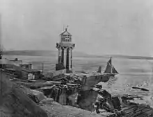
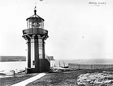
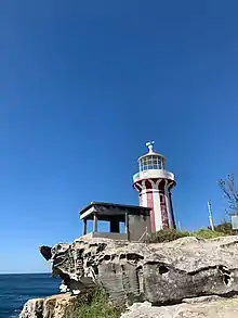
 Hornby Lighthouse, 2010 | |
| Location | South Head, Sydney, New South Wales, Australia |
|---|---|
| Coordinates | 33°50′1″S 151°16′52″E / 33.83361°S 151.28111°E |
| Tower | |
| Constructed | 1858 |
| Construction | Sandstone tower |
| Automated | 1933 |
| Height | 9.1 metres (30 ft) |
| Shape | Cylindrical tower with balcony and lantern |
| Markings | Striped vertically red and white tower, white gallery and lantern |
| Operator | |
| Heritage | Heritage Act — State Heritage Register |
| Light | |
| Focal height | 27.4 metres (90 ft) |
| Lens | First order catoptric lens |
| Range | 14 nautical miles (26 km; 16 mi)[note 1] |
| Characteristic | L Fl W 5s. |
Building details | |
| Design and construction | |
| Architect(s) | Mortimer Lewis |
| Official name | South Head Signal Station |
| Type | State heritage (built) |
| Designated | 18 April 2000 |
| Reference no. | 01436 |
| Type | Signal Stations |
| Category | Transport – Water |
Hornby Lighthouse, also known as South Head Lower Light or South Head Signal Station, is a heritage-listed active lighthouse located on the tip of South Head, New South Wales, Australia, a headland to the north of the suburb Watsons Bay. It marks the southern entrance to Port Jackson,[1] as well as lighting the South Reef, a ledge of submerged rocks.[2] It is the third oldest lighthouse in New South Wales.[3] Designed by Mortimer Lewis and listed on the (now defunct) Register of the National Estate[4] and on the New South Wales State Heritage Register since 2 April 1999, with the following statement of significance:[5]
A dominant Sydney landmark which appears to have been in continuous use since the 1840s as a controlling point for shipping entering and leaving Port Jackson. The building complex, designed by the Colonial Architect Mortimer Lewis in the early 1840s, is an architectural important example of an early Victorian public work associated with port activities.
— Statement of significance as listed on the New South Wales State Heritage Register.
History


The need for a lighthouse at the entrance of Jackson Bay was made evident by the loss of two ships. First was the Dunbar, wrecked in August 1857, with the loss of 121 lives. The second was Catherine Adamson,[6] two months later in October 1857, with a loss of twenty-one lives.[7] The first signal station was operated close to the present site in 1790, serving as a landmark for ships to communicate their arrival to the settlement.[5][8] A committee of the Light, Pilot and Navigation Board took evidence in September 1857 and recommended the construction of a 9.1-metre (30 ft) lighthouse on the inner South Head, showing a fixed white light (F.W.), although a red light was also considered.[9]
The South Head Signal Station is a dominant Sydney landmark which appears to have been in continuous use since the 1840s as a controlling point for shipping entering and leaving Port Jackson.[5]
A solid sandstone tower with connected watch keepers quarters built in the early 1840s and designed by the Colonial Architect Mortimer Lewis. The tower is octagonal in plan having four levels and a basement store cut 10 feet into a solid rock. The topmost level has a cantilevered iron and timber catwalk and the metal pitched roof is surmounted by an observation fleche. Decoration is minimal but the form of the shaft with simple stepping, string courses and small panel oval and square windows is typical of restrained Colonial Georgian building work.[5] It was also reported that the government stores already had a catoptric lens apparatus available that has been purchased in 1853.[9]
The wing for staff quarters in an "I" plan with enclosed verandahs either side. This building probably c. 1850s building having very good ashlar work to external walls with each elevation recessed within a frame of foundation, eaves and quoin mouldings. Windows are marked by simple classical sill and lintel mouldings. The hipped roofs originally of slate are now sheeted in asbestos cement.[5] A good timber picket fence encloses the property which is in good condition and well maintained.[5][10]
After coming onto the real estate market for the first time, the two-bedroom Cottage One of the Signal Station has been leased on the first inspection, by a young family. The two-bedroom cottage has its own 1795 cannon in the yard. It was built in the 1840s, has a new kitchen and bathroom, and was most recently used as housing for NSW Maritime Services personnel.[8][5]
The tower construction ended in 1858, and it was the third lighthouse built in New South Wales, following Macquarie Lighthouse in 1818 and Nobbys Head Light in 1858.[3] It was opened by Sir William Denison, Governor of New South Wales, and named after the family of his wife Caroline,[2] daughter of Admiral Sir Phipps Hornby,[3][4][11] though it was known as the "Lower Light", to distinguish it from Macquarie Lighthouse, the "Upper Light".[3]
The original apparatus was a first order catoptric lens, and the light source was a kerosene lamp.[2][3] Also built with the lighthouse was a sandstone keeper's cottage, also designed by Dawson. A second cottage was constructed in 1860, and two rooms were added to each of the cottages in 1877. The cottages were connected to the city water only in 1897, using stored waters until then.[3] In 1904 the light was upgraded to incandescent gas,[note 2] In 1933 the light was electrified, and the lighthouse was automated and demanned.[3][4] In 1948 a Chance Brothers catadioptric lens was installed, and the light characteristic was changed to a rhythmic light.[3]
Following the automation of the lighthouse in 1933, the lighthouse and cottages fell into disuse. With World War II the shoreline fell under control of the Army, and remained so until 1977, housing serving married personnel. Following classification by the National Trust in 1975, the army transferred the station to the NSW National Parks & Wildlife Service, which restored the cottages and instated caretakers.[3] The light's current characteristic is a white light showing two seconds on, three seconds off (L.Fl.W. 5s),[12] visible for 15 nautical miles (28 km; 17 mi).[note 3]
Description
The site of the first navigational beacon in Australia providing warning to mariners.[13][5]
A dominant Sydney landmark which appears to have been in continuous use since the 1840s as a controlling point for shipping entering and leaving Port Jackson.[5]
A solid sandstone tower with connected watch keepers quarters built in the early 1840s and designed by the Colonial Architect Mortimer Lewis. The tower is octagonal in plan having four levels and a basement store cut 10 feet into a solid rock. The topmost level has a cantilevered iron and timber catwalk and the metal pitched roof is surmounted by an observation fleche. Decoration is minimal but the form of the shaft with simple stepping, string courses and small panel oval and square windows is typical of restrained Colonial Georgian building work. The wing for staff quarters in an "I" plan with enclosed verandahs either side. This building probably c. 1850s building having very good ashlar work to external walls with each elevation recessed within a frame of foundation, eaves and quoin mouldings. Windows are marked by simple classical sill and lintel mouldings. The hipped roofs originally of slate are now sheeted in asbestos cement. A good timber picket fence encloses the property which is in good condition and well maintained.[5][10]

The lighthouse is a tapered circular structure, built of curved dressed sandstone[3] and standing 9.1 metres (30 ft) above the ground.[12] It is painted with distinctive red and white vertical stripes. The sandstone was quarried locally.[3]
On top of the tower is a non-ferrous metal balcony and railing, painted white, surrounded the glass-enclosed lamp.[2][4]
To the west of the tower are the two Georgian style sandstone cottages, now painted, constructed from the same locally queried sandstone, and having timber verandahs and picket fences.[4] The original slate roofing has been replaced with corrugated asbestos.[4]
Condition
As at 26 May 1998, A good timber picket fence encloses the property which is in good condition and well maintained.[10][5]

Modifications and dates
The hipped roofs originally of slate are now sheeted in asbestos cement.[10][5]
Site operation
The light is operated by the Sydney Ports Corporation, while the site is managed by the NSW National Parks & Wildlife Service as part of the Sydney Harbour National Park.[1][3] The site is open and accessible to the public, but the tower itself is closed.[1] It can be reached by walking along the South Head Heritage Trail through Sydney Harbour National Park, starting at Camp Cove.[14]
Heritage listing
Hornby Lighthouse was listed on the New South Wales State Heritage Register on 18 April 2000.[5]
See also
Notes
References
- 1 2 3 Rowlett, Russ. "Lighthouses of Australia: Southern New South Wales". The Lighthouse Directory. University of North Carolina at Chapel Hill. Retrieved 29 August 2010.
- 1 2 3 4 "Hornby Light" (PDF). Woollahra Library Local History Centre. Woollahra Council. Archived from the original (PDF) on 18 April 2019. Retrieved 21 September 2010.
- 1 2 3 4 5 6 7 8 9 10 11 12 13 "The Hornby Lighthouse at South Head". Lighthouses of New South Wales. Lighthouses of Australia Inc.
- 1 2 3 4 5 6 "Hornby Lighthouse Group, Hornby Light Rd, Watsons Bay, NSW, Australia (Place ID 2516)". Australian Heritage Database. Australian Government. Retrieved 15 September 2017.
- 1 2 3 4 5 6 7 8 9 10 11 12 13 "South Head Signal Station". New South Wales State Heritage Register. Department of Planning & Environment. H01436.
 Text is licensed by State of New South Wales (Department of Planning and Environment) under CC-BY 4.0 licence.
 - ↑ "CATHERINE ADAMSON". Aberdeen Ships. 24 March 2023.
- ↑ "WRECK OF THE CATHERINE ADAMSON". Sydney Morning Herald. Vol. XXXVIII, no. 6062. New South Wales, Australia. 10 November 1857. p. 8 – via National Library of Australia.
- 1 2 Melocco, 2013
- 1 2 "Parliamentary Papers. Additional Lighthouse for Port Jackson". Sydney Morning Herald. Vol. XXXVIII, no. 6052. New South Wales, Australia. 29 October 1857. p. 3. Retrieved 12 March 2017 – via National Library of Australia.
- 1 2 3 4 Sheedy, D., 1976.
- ↑ "MISCELLANEOUS SHIPPING". The Tasmanian Telegraph. Vol. I, no. 2. Tasmania, Australia. 26 June 1858. p. 4. Retrieved 12 March 2017 – via National Library of Australia.
- 1 2 List of Lights, Pub. 111: The West Coasts of North and South America (Excluding Continental U.S.A. and Hawaii), Australia, Tasmania, New Zealand, and the Islands of the North and South Pacific Oceans (PDF). List of Lights. United States National Geospatial-Intelligence Agency. 2009. p. 126.
- ↑ Anglin 1990:1050
- ↑ "Sydney Harbour National Park – Exploring cultural heritage in the park". Office of Environment & Heritage. Retrieved 22 September 2010.
Bibliography
- Anglin Associates (1990). Maritime Services Board Heritage and Conservation Register : Sydney Harbour.
- Hughes, Trueman, Ludlow Pty Ltd; Howard Tanner & Assoc; Jack, Prof. Ian; Ashton, W. (1984). Woollahra Heritage Study.
{{cite book}}: CS1 maint: multiple names: authors list (link) - Melocco, Jen (2013). Family at home in historical signal station.
- Sheedy, D. (1976). National Trust of Australia (NSW) Classification.
- Heritage Unit, Department of Public works & Services (1999). Marine Ministerial Holding Corporation S170 Register.
Attribution
![]() This Wikipedia article contains material from South Head Signal Station, entry number 01436 in the New South Wales State Heritage Register published by the State of New South Wales (Department of Planning and Environment) 2018 under CC-BY 4.0 licence, accessed on 2 June 2018.
This Wikipedia article contains material from South Head Signal Station, entry number 01436 in the New South Wales State Heritage Register published by the State of New South Wales (Department of Planning and Environment) 2018 under CC-BY 4.0 licence, accessed on 2 June 2018.
External links
- Searle, Garry. "Hornby Light". Lighthouses of New South Wales. SeaSide Lights.
- Sortland, Julian. "Hornby Lighthouse". Archived from the original on 30 September 2009.
- "Grant and Tracey's Lighthouse Pages – Hornby Lighthouse".
- "Hornby lighthouse". Dictionary of Sydney. 2008. Retrieved 7 October 2015. [CC-By-SA]
