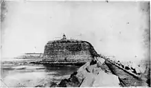
 Nobbys Head Light, 1902 | |
| Location | Nobbys Head, Newcastle, New South Wales, Australia |
|---|---|
| Coordinates | 32°55′6.86″S 151°47′54.27″E / 32.9185722°S 151.7984083°E |
| Tower | |
| Constructed | 1821 (first) |
| Construction | dressed sandstone |
| Automated | 1935 |
| Height | 9.8 metres (32 ft)[lower-alpha 1] |
| Shape | cylindrical tower with balcony and lantern |
| Markings | white tower and lantern |
| Operator | Australian Maritime Safety Authority |
| Heritage | listed on the Commonwealth Heritage List |
| Fog signal | siren: 1 blast every 20s. |
| Light | |
| First lit | 1858 (current)[lower-alpha 2] |
| Focal height | 35 metres (115 ft)[lower-alpha 3] |
| Intensity | 580,000 cd |
| Range | 24 nmi (44 km; 28 mi) |
| Characteristic | Fl (3) W 20s. |
| Official name | Nobbys Lighthouse |
| Type | Historic |
| Criteria | A.1, A.4, B.2, F.1, G.1 |
| Designated | 22 June 2004 |
| Reference no. | 105373 |
Nobbys Head Light is an active lighthouse on Nobbys Head, a headland on the south side of the entrance to Newcastle Harbour, New South Wales, Australia.[1][2][3][4] An image of the lighthouse is included in the coat of arms of the City of Newcastle.[5]
The lighthouse is operated by the Newcastle Port Corporation. The headland is managed by the Land Property Management Authority[6] and is open to the public Sundays from 10am to 4pm.
History
The first beacon in the area was an open coal fire set on Signal Head, with a range of 7 kilometres (4.3 mi; 3.8 nmi). This was changed in 1821 to a large metal device burning oil, which was visible for 12 kilometres (7.5 mi; 6.5 nmi), but shortly reverted to coal as the oil system was not reliable.
By 1846 Nobbys Head, originally a small islet more than 60 metres (200 ft) high, was connected to the mainland with a causeway. The island was reduced in height to improve the sailing conditions and to accommodate a lighthouse and signal station, built in 1858. The lighthouse was designed by Alexander Dawson, the New South Wales Government Architect. The original light had an intensity of 20,000 cd and was attended by three lighthouse keepers.
In 1934 the light was electrified and automated.
The current light source is a 120-electronvolt (19 aJ) 1,000-watt (1.3 hp), quartz halogen lamp and the power source is mains electricity with a diesel generator as backup. Currently at the site are three one-story keeper's houses, a three-story signal station, and other buildings housing the port watch. The entire station is floodlit at night.
Heritage listing
On 22 June 2004, the lighthouse and associated structures were registered on the Commonwealth Heritage List.[7] On 21 October 1980, the lighthouse was listed on the (now defunct) Register of the National Estate.[8]
Gallery
 Nobbys Head, 2009
 Nobbys Head in 1887
 View of Nobbys Head from a distance
See also
Notes
References
- 1 2 3 List of Lights, Pub. 111: The West Coasts of North and South America (Excluding Continental U.S.A. and Hawaii), Australia, Tasmania, New Zealand, and the Islands of the North and South Pacific Oceans (PDF). List of Lights. United States National Geospatial-Intelligence Agency. 2009. p. 124.
- 1 2 Rowlett, Russ. "Lighthouses of Australia: Northern New South Wales". The Lighthouse Directory. University of North Carolina at Chapel Hill. Retrieved 29 August 2010.
- ↑ "The Nobbys Head Lighthouse at Newcastle". Lighthouses of New South Wales. Lighthouses of Australia Inc.
- ↑ Searle, Garry. "Nobby". Lighthouses of New South Wales. SeaSide Lights.
- ↑ "Commonwealth heritage places in New South Wales (Nobbys Lighthouse, Newcastle East)". Department of the Environment, Water, Heritage and the Arts. Retrieved 21 July 2008.
- ↑ McMahon, Jeannette (23 November 2010). "Opening Nobbys headland to the public". ABC News. Newcastle, Australia. Retrieved 23 March 2013.
- ↑ "Nobbys Lighthouse (Place ID 105373)". Australian Heritage Database. Australian Government. 22 June 2004. Retrieved 3 November 2017.
- ↑ "Nobbys Lighthouse (Place ID 1311)". Australian Heritage Database. Australian Government. 21 October 1980. Retrieved 3 November 2017.
External links
- "Nobbys Lighthouse Headland & Breakwater (Coal Rover Precinct)". New South Wales State Heritage Register. Department of Planning & Environment. Retrieved 3 November 2017.
 Text is licensed by State of New South Wales (Department of Planning and Environment) under CC-BY 4.0 licence.
 - "Nobbys Signal Station". New South Wales State Heritage Register. Department of Planning & Environment. Retrieved 3 November 2017.
 Text is licensed by State of New South Wales (Department of Planning and Environment) under CC-BY 4.0 licence.
 - "Nobbys Lighthouse Cottages". New South Wales State Heritage Register. Department of Planning & Environment. Retrieved 3 November 2017.
 Text is licensed by State of New South Wales (Department of Planning and Environment) under CC-BY 4.0 licence.
 - "Nobbys Grounds". New South Wales State Heritage Register. Department of Planning & Environment. Retrieved 3 November 2017.
 Text is licensed by State of New South Wales (Department of Planning and Environment) under CC-BY 4.0 licence.
