Hoscheid
Houschent | |
|---|---|
Former commune | |
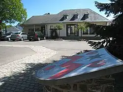 The town hall | |
 Coat of arms | |
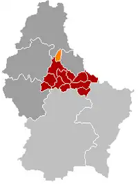 Map of Luxembourg with Hoscheid highlighted in orange, and the canton in dark red | |
| Coordinates: 49°56′50″N 6°04′50″E / 49.9472°N 6.0806°E | |
| Country | |
| Canton | Clervaux |
| Time zone | UTC+1 (CET) |
| • Summer (DST) | UTC+2 (CEST) |
| Website | hoscheid.lu |
Hoscheid (Luxembourgish: Houschent) is a small town in north-eastern Luxembourg. It was a commune, part of the canton of Diekirch, which was part of the district of Diekirch.
On January 1, 2012, the commune merged with Consthum and Hosingen communes to form Parc Hosingen commune; thereby becoming part of Clervaux canton.
As of 2021, the town of Hoscheid, which lies in the south of the commune, had a population of 473.
Among local personalities is Jean Ersfeld, who, in 2004, led his party, the Free Party of Luxembourg in the legislative elections.
Former commune
The former commune consisted of the villages:
- Houscheid
- Houscheid-Dickt
- Oberschlinder
- Unterschlinder
- Markebach (lieu-dit)
- Kehrmuhle (lieu-dit)
- Schilkeschleedchen where a firing range of the Luxembourg Armed Forces is located
Wikimedia Commons has media related to Hoscheid.
 | ||
This article is issued from Wikipedia. The text is licensed under Creative Commons - Attribution - Sharealike. Additional terms may apply for the media files.