Schieren
Schieren | |
|---|---|
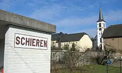 Schieren train station and church | |
 Coat of arms | |
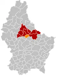 Map of Luxembourg with Schieren highlighted in orange, and the canton in dark red | |
| Coordinates: 49°50′00″N 6°06′00″E / 49.8333°N 6.1°E | |
| Country | |
| Canton | Diekirch |
| Area | |
| • Total | 10.41 km2 (4.02 sq mi) |
| • Rank | 94th of 102 |
| Highest elevation | 515 m (1,690 ft) |
| • Rank | 15th of 102 |
| Lowest elevation | 198 m (650 ft) |
| • Rank | 24th of 102 |
| Population | |
| • Total | 2,149 |
| • Rank | 73rd of 102 |
| • Density | 210/km2 (530/sq mi) |
| • Rank | 39th of 102 |
| Time zone | UTC+1 (CET) |
| • Summer (DST) | UTC+2 (CEST) |
| LAU 2 | LU0000609 |
| Website | schieren.lu |
Schieren is a commune and town in central Luxembourg. It is part of the canton of Diekirch.
The town of Schieren, which lies in the west of the commune, has a population of 2,149. Schieren is served by a railway station.
Schieren was formed on 1 July 1850, when it was detached from the commune of Ettelbruck, along with the commune of Erpeldange. The law forming Schieren was passed on 22 January 1850.[1]
In 1894, Schieren established a fire station with five volunteer firefighters. It has a notable church.
Population
Footnotes
- ↑ (in French and German) "Mémorial A, 1850, No. 18" (PDF). Service central de législation. Retrieved 2006-08-15.
- ↑ "Population par canton et commune". statistiques.public.lu. Retrieved 11 January 2022.
External links
 Media related to Schieren (Luxembourg) at Wikimedia Commons
- (in French) Commune of Schieren official website
- (in German) Unofficial website on local activities
Places adjacent to Schieren | |
|---|---|
 | ||
This article is issued from Wikipedia. The text is licensed under Creative Commons - Attribution - Sharealike. Additional terms may apply for the media files.