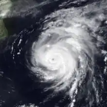
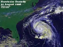
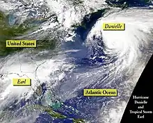
 Danielle as a Category 2 hurricane on September 1 | |
| Meteorological history | |
|---|---|
| Formed | August 24, 1998 |
| Extratropical | September 3, 1998 |
| Dissipated | September 8, 1998 |
| Category 2 hurricane | |
| 1-minute sustained (SSHWS/NWS) | |
| Highest winds | 105 mph (165 km/h) |
| Lowest pressure | 960 mbar (hPa); 28.35 inHg |
| Overall effects | |
| Fatalities | None |
| Damage | $50,000 (1998 USD) |
| Areas affected | East Coast of the United States, Northeastern United States, Atlantic Canada, British Isles |
| IBTrACS | |
Part of the 1998 Atlantic hurricane season | |
Hurricane Danielle was a long-lived Cape Verde hurricane in late August and early September 1998. The fourth named storm and second hurricane of the annual hurricane season, Danielle originated from a tropical wave that emerged off the western coast of Africa on August 21. Tracking generally west-northwestward, the disturbance was initially disorganized; under favorable atmospheric conditions, shower and thunderstorm activity began to consolidate around a low-pressure center. Following a series of satellite intensity estimates, the system was upgraded to Tropical Depression Four during the pre-dawn hours of August 24, and further to Tropical Storm Danielle that afternoon. Moving around the southern periphery of the Azores High located in the northeastern Atlantic, quick intensification to hurricane status occurred early on August 25. By 0600 UTC the following day, Danielle reached an initial peak intensity of 105 mph (169 km/h), a Category 2 hurricane. Increased wind shear from a nearby trough encroached on further development later that day, and subsequently led to slight weakening. By 1200 UTC on August 27, despite continued unfavorable conditions, Danielle reached a second peak intensity equal to the first. Weakening once ensued late on August 27 in addition to the days following, and Danielle was a low-end Category 1 hurricane by August 31 as its forward speed slowed.
As the cyclone reached the western periphery of the ridge that steered it across the Atlantic for much of its existence, it began yet another period of intensification, and once again attained a peak intensity as a Category 2 hurricane. Passing northwest of Bermuda, Danielle weakened to Category 1 hurricane strength, but for a final time intensified into a 105 mph (169 km/h) tropical cyclone thereafter. As the cyclone passed over increasingly cool sea surface temperatures and became intertwined in a baroclinic zone, it began to undergo an extratropical transition. At 0000 UTC on September 4, Danielle was no longer considered a tropical cyclone, despite retaining hurricane-force winds. Several days later, the remnants of Danielle merged with a larger extratropical low and became indistinguishable. As a tropical cyclone, it produced heavy rainfall in Puerto Rico and the Lesser Antilles, leading to flooding. Tropical storm-force winds were observed in Bermuda even though the cyclone passed well northwest of the island. During Danielle's transition to an extratropical cyclone, it produced light rain and led to minor beach erosion in Newfoundland. The larger extratropical low that merged with the system resulted in large waves off the coast of the United Kingdom, leading to major beach erosion and coastal flooding. Overall, no fatalities were reported with the system and it caused an estimated $50,000 (1998 USD) in damage.
Meteorological history

Tropical storm (39–73 mph, 63–118 km/h)
Category 1 (74–95 mph, 119–153 km/h)
Category 2 (96–110 mph, 154–177 km/h)
Category 3 (111–129 mph, 178–208 km/h)
Category 4 (130–156 mph, 209–251 km/h)
Category 5 (≥157 mph, ≥252 km/h)
Unknown

The origins of Hurricane Danielle trace back to a tropical wave that emerged off the western coast of Africa and into the eastern Atlantic Ocean early on August 21. Tracking west-northwestward, the National Hurricane Center (NHC) began Dvorak satellite intensity estimates later that morning following the consolidation of convection – shower and thunderstorm activity – near the system's center. Favorable atmospheric conditions led to further organization, and it is estimated that the disturbance intensified into a tropical depression by 0600 UTC on August 24, while located roughly 690 miles (1,110 km) west-southwest of the Cape Verde Islands.[1] Operationally, the National Hurricane Center initiated advisories at 1530 UTC and noted that the depression was already on the verge of tropical storm intensity.[2] The depression was upgraded to Tropical Storm Danielle later on August 24 following an increase in organization on satellite imagery.[1][3]
As the cyclone moved northwestward along the southern periphery of the Azores High, it began a period of rapid deepening in which a "pinhole" eye became distinguishable on satellite imagery; on this basis, Danielle was upgraded to a hurricane at 1200 UTC on August 25. At the time, Danielle was a compact system, with tropical storm force winds spanning only 115 miles (185 km) from the center.[1] Although the NHC was fairly certain that the storm would continue west-northwestward, a veer north or south of the forecast track seemed plausible due to the influence of an upper-level low to the west-northwest of Danielle.[4] Nonetheless, the storm continued its west-northwest track. At 0600 UTC on August 26, Danielle attained its maximum sustained wind speed of 105 mph (169 km/h), one of four peak intensities.[1] Although the eye became obscured and southeasterly vertical wind shear increased late on August 26, the National Hurricane Center did not indicate weakening and instead predicted that Danielle would reach winds of 120 mph (190 km/h) by late on August 27.[5] Early on August 27, a United States Air Force reconnaissance aircraft flight reported surface winds of 80 mph (130 km/h),[6] though post-analysis indicates that the intensity of the storm was underestimated.[1]
The storm briefly re-strengthened slightly on August 27, reaching its maximum sustained wind speed of 105 mph (169 km/h) for the second time at 1200 UTC. Vertical wind shear persisted and Danielle soon began to weaken again.[1] Later on August 27, the National Hurricane Center predicted that the storm would travel along the periphery of an anticyclone centered just east of Bermuda, which would keep the storm away from the East Coast of the United States.[7] Despite being in an apparently favorable environment,[8] Danielle continued to slowly weaken,[1] as the forecast for decreasing wind shear did not initially materialize.[9] Additionally, upwelling from Hurricane Bonnie roughly a week earlier contributed to a decrease in strength.[1] Although the storm weakened further, reconnaissance aircraft observations on August 29 concluded that the structure of Danielle had improved compared to the previous day.[10] By early on August 30, Danielle had weakened to the extent that it was only a minimal hurricane, with maximum winds of 75 mph (121 km/h) at the time.[1] On August 30, the National Hurricane Center noted that Danielle would soon leave the upwelling track left by Bonnie, and likely lead to intensification. Thus, the possibility of re-strengthening increased, though predictions only showed gradual intensification.[11]

By early on August 31, an increase in sustained winds, a decrease in barometric pressure, and a 23 miles (37 km) wide eye observed by reconnaissance aircraft all suggested that Danielle was beginning to intensify.[12] On August 31, the anticyclone near Bermuda caused Danielle to curve northeastward, away from the East Coast of the United States. Later that day, a significant increase in intensity led the storm to again reach its maximum sustained wind speed of 105 mph (169 km/h). On September 1, there was significant uncertainty in the future intensity of Danielle, as a shortwave trough located northeast of the storm would either enhance outflow, causing strengthening, or increase wind shear, resulting in weakening.[13] At 1500 UTC on September 1, it was predicted that Danielle would strengthen slightly before weakening and becoming extratropical by September 3.[14] Three hours later, Danielle reached its maximum sustained wind speed of 105 mph (169 km/h) for the fourth and final time.[1]
Early on September 2, the storm weakened again and was downgraded to a Category 1 hurricane. At 0600 UTC on September 3, Danielle reached its minimum barometric pressure of 960 mbar (960 hPa; 28 inHg), although sustained winds were only 80 mph (130 km/h) at the time.[1] As late as 1500 UTC on September 3, satellite imagery indicated that Danielle was retaining tropical characteristics. The National Hurricane Center did not forecast any further weakening before the extratropical transition, but instead mentioned the possibility of baroclinic strengthening.[15] Late on September 3, the final advisory was issued on the transitioning storm.[16] Danielle officially transitioned into an extratropical cyclone at 0000 UTC on September 4 according to a post-season report from the NHC, while located east-southeast of Newfoundland. The remnants of Danielle traversed east and eventually northeastward across the Atlantic Ocean. It produced rough seas in the British Isles on September 6 before merging with an extratropical low pressure area north of Ireland on September 8.[1]
Preparations and impact
Shortly after formation, Danielle was considered a potential threat to the Lesser Antilles, with the National Hurricane Center noting that "any deviation to the left of the track would bring Danielle closer [to] the Leeward Islands."[17] However, Danielle bypassed far enough north of the Lesser Antilles to prevent any tropical storm or hurricane watches or warnings.[1] Several days later, the storm was considered a possible threat to Florida by local newspapers,[18] though the National Hurricane Center accurately predicted a re-curvature from the United States mainland well in advance. At 1500 UTC on September 1, at which time Danielle was situated northeast of the Bahamas, a tropical storm warning was issued for Bermuda; this was later cancelled after Danielle passed northwest of the island.[1]
The outer bands of Danielle produced heavy rainfall in Puerto Rico, causing street flooding and landslides in Bayamón, Guaynabo, Toa Alta, and Vega Alta; several streams overflowed their banks, causing additional flooding. In a neighborhood of Bayamón, one house was damaged after a wall collapsed. Losses in Puerto Rico totaled to approximately $50,000 (1998 USD).[19] Hurricane Bonnie ripped an artificial reef composed of tires offshore Atlantic Beach, North Carolina in late August. Danielle washed numerous of these loose tires ashore, especially on Emerald Isle. As a result, the Governor of North Carolina, Jim Hunt, requested prison labor and the National Guard to clean up beaches from Brunswick County to Carteret County.[20] Instead of resulting in further erosion in the aftermath of Bonnie farther up along the coast, Danielle led to a 1 mile (1.6 km) increase in sand along the New Jersey coastline.[21] In Bermuda, sustained winds of 39 mph (63 km/h) and a gust of 54 mph (87 km/h) were reported on September 2.[1] Offshore Atlantic Canada, wave heights reached as high as 82 feet (25 m). However, other than light rainfall in Newfoundland, the storm caused no impact in Canada.[22] Tori Murden, an American attempting to become the first woman to solo row across the Atlantic Ocean, encountered rough seas from the storm and its remnants. By September 7, Murden sent out a distress signal and was rescued by the Independent Spirit later that day.[23]
While passing near the British Isles on September 6 as an extratropical storm, Danielle produced severe sea conditions on the western part of the isles. Major beach erosion was observed, and many people required rescuing. Coastal portions of Cornwall were evacuated as high waves inundated many homes, and an all-terrain police vehicle was shoved into the sea by a rogue wave in the Isles of Scilly.[1] An 11‑year-old boy and his father were trapped in a sea cave on the north coast of Cornwall due to rough surf. Two other men from Port Isaac also became isolated in the same location after their boat capsized. All four were eventually rescued by a helicopter that hovered near the entrance of the sea cave.[24] At the West Sands Caravan Park near Selsey, West Sussex, twelve families were evacuated to higher ground. A yacht carrying eight people ran aground near Calshot; they required rescuing by the Solent Coastguards.[25] Flash flooding was reported throughout Wiltshire, especially in the town of Melksham. Numerous motorists were left stranded in inundated streets, while water entered several homes, store basements, a fire station, and the Cooper Avon tyre factory.[26]
See also
References
- 1 2 3 4 5 6 7 8 9 10 11 12 13 14 15 16 Richard Pasch (January 19, 1999). "Preliminary Report: Hurricane Danielle". National Hurricane Center. Retrieved September 3, 2012.
- ↑ Edward Rappaport (August 24, 1998). "Tropical Depression Four Special Discussion Number 1". National Hurricane Center. Retrieved September 2, 2012.
- ↑ Edward Rappaport (August 24, 1998). "Tropical Storm Danielle Discussion Number 2". National Hurricane Center. Retrieved September 2, 2012.
- ↑ Brian Jarvinen (August 26, 1998). "Hurricane Danielle Discussion Number 7". National Hurricane Center. Retrieved September 2, 2012.
- ↑ John Guiney (August 26, 1998). "Hurricane Danielle Discussion Number 8". National Hurricane Center. Retrieved September 3, 2012.
- ↑ James Gross (August 26, 1998). "Hurricane Danielle Discussion Number 11". National Hurricane Center. Retrieved September 3, 2012.
- ↑ James Gross (August 26, 1998). "Hurricane Danielle Discussion Number 14". National Hurricane Center. Retrieved September 3, 2012.
- ↑ Lixion Avila (August 28, 1998). "Hurricane Danielle Discussion Number 18". National Hurricane Center. Retrieved September 3, 2012.
- ↑ James Gross (August 29, 1998). "Hurricane Danielle Discussion Number 20". National Hurricane Center. Retrieved September 3, 2012.
- ↑ Lixion Avila (August 29, 1998). "Hurricane Danielle Discussion Number 22". National Hurricane Center. Retrieved September 3, 2012.
- ↑ Richard Pasch (August 30, 1998). "Hurricane Danielle Discussion Number 26". National Hurricane Center. Retrieved September 3, 2012.
- ↑ John Guiney (August 31, 1998). "Hurricane Danielle Discussion Number 27". National Hurricane Center. Retrieved September 3, 2012.
- ↑ Max Mayfield (September 1, 1998). "Hurricane Danielle Discussion Number 31". National Hurricane Center. Retrieved September 3, 2012.
- ↑ Miles Lawrence (September 1, 1998). "Hurricane Danielle Discussion Number 33". National Hurricane Center. Retrieved September 3, 2012.
- ↑ Brian Jarvinen (September 3, 1998). "Hurricane Danielle Discussion Number 41". National Hurricane Center. Retrieved September 3, 2012.
- ↑ Brian Jarvinen (September 3, 1998). "Hurricane Danielle Discussion Number 42". National Hurricane Center. Retrieved September 3, 2012.
- ↑ Lixion Avila (August 25, 1998). "Hurricane Danielle Discussion Number 6". National Hurricane Center. Retrieved September 2, 2012.
- ↑ Mark Zaloudek (August 27, 1998). "Floridians turn attention to Hurricane Danielle". Sarasota Herald-Tribune. Retrieved September 2, 2012.
- ↑ Stephen Del Greco. "Storm Data - August 1998" (PDF). National Climatic Data Center. p. 141. Archived from the original (PDF) on April 25, 2013. Retrieved September 2, 2012.
- ↑ "Volunteers still clearing tires from beaches". Associated Press. September 5, 1998.
- ↑ Karen DeMasters (September 6, 1998). "Offshore Hurricanes Swipe, Then Return Sand". The New York Times.
- ↑ "1998-Danielle". Environment Canada. September 14, 2010. Retrieved September 2, 2012.
- ↑ Steve Bailey (September 15, 1998). "Rower who tried to cross Atlantic gets warm welcome home". Associated Press.
- ↑ Geoffrey Gibbs (September 8, 1998). "Boy, 11, in sea cave drama praised for helping to keep his father alive". The Guardian.
- ↑ Sarah Westcott (September 9, 1998). "Relief as sea threat passes". Press Association.
- ↑ Nigel Kerton (September 10, 1998). "Storm floods fire station". Western Daily Press.
