Jennelt | |
|---|---|
 | |
 Coat of arms | |
Location of Jennelt | |
 Jennelt 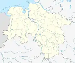 Jennelt | |
| Coordinates: 53°27′49″N 7°07′50″E / 53.46371°N 7.13052°E | |
| Country | Germany |
| State | Lower Saxony |
| District | Aurich |
| Municipality | Krummhörn |
| Area | |
| • Metro | 3.57 km2 (1.38 sq mi) |
| Elevation | 1 m (3 ft) |
| Population | |
| • Metro | 362 |
| Time zone | UTC+01:00 (CET) |
| • Summer (DST) | UTC+02:00 (CEST) |
| Postal codes | 26736 |
| Dialling codes | 04923 |
Jennelt is a village in the region of East Frisia, in Lower Saxony, Germany. It is part of the municipality of Krummhörn. The village is located to the east of Visquard and to the south of Eilsum.
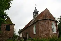
Jennelt was built on a warft and already mentioned as Gein Leth in the 8th/9th century. Other early spellings include Geenlede, Jennlede, Jennlete, and Jennlet.[1] In the last half of the 13th century, the Church of Jennelt was built on the western side of the elongated village.[2]
Gallery
 Chapel in Jennelt
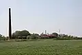 Former brickworks near Jennelt
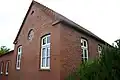
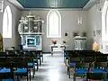 Interior of the church
References
- ↑ "Jennelt". Greetsiel-Krummhoern.de (in German). Retrieved 18 October 2023.
- ↑ "Evangelisch-Reformierte Kirche Jennelt". Ostfriesland (in German). Retrieved 18 October 2023.
External links
 Media related to Jennelt at Wikimedia Commons
This article is issued from Wikipedia. The text is licensed under Creative Commons - Attribution - Sharealike. Additional terms may apply for the media files.