Manslagt | |
|---|---|
_IMG_6638.jpg.webp) | |
 Coat of arms | |
Location of Manslagt | |
 Manslagt 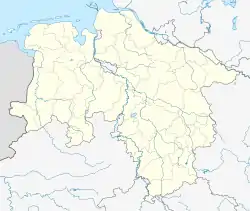 Manslagt | |
| Coordinates: 53°27′28″N 7°03′43″E / 53.45769°N 7.06199°E | |
| Country | Germany |
| State | Lower Saxony |
| District | Aurich |
| Municipality | Krummhörn |
| Area | |
| • Metro | 8.65 km2 (3.34 sq mi) |
| Elevation | 1 m (3 ft) |
| Population | |
| • Metro | 410 |
| Time zone | UTC+01:00 (CET) |
| • Summer (DST) | UTC+02:00 (CEST) |
| Postal codes | 26736 |
| Dialling codes | 04923 |
Manslagt is a village in the region of East Frisia, in Lower Saxony, Germany. It is part of the municipality of Krummhörn. The village is located between Pilsum and Groothusen.
Manslagt was historically located on an island in the former Bay of Sielmönken and was built on a warft. It was first mentioned around the 11th century.[1] The Church of Manslagt dates from around 1400.[2]
Gallery
.jpg.webp) Location of Manslagt on a map by Ubbo Emmius, 1600
Location of Manslagt on a map by Ubbo Emmius, 1600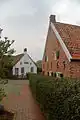 Houses in Manslagt
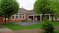 Former school, now kindergarten
 Bronze model of Manslagt
Notable people
- Klaus Immer (1924–2022), politician
References
- ↑ "Manslagt". Wierden en terpen (in Dutch). Retrieved 17 October 2023.
- ↑ "Evangelische-Reformierte Kirche Manslagt". Krummhörn Greetsiel (in German). Retrieved 17 October 2023.
External links
![]() Media related to Manslagt at Wikimedia Commons
Media related to Manslagt at Wikimedia Commons
This article is issued from Wikipedia. The text is licensed under Creative Commons - Attribution - Sharealike. Additional terms may apply for the media files.