Joutsa | |
|---|---|
Municipality | |
| Joutsan kunta Joutsa kommun | |
 | |
 Coat of arms | |
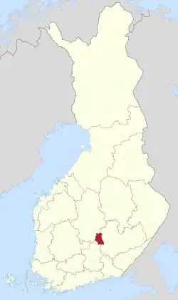 Location of Joutsa in Finland | |
| Coordinates: 61°44.5′N 026°07′E / 61.7417°N 26.117°E | |
| Country | |
| Region | Central Finland |
| Sub-region | Joutsa sub-region |
| Government | |
| • Municipal manager | Harri Nissinen |
| Area (2018-01-01)[1] | |
| • Total | 1,066.42 km2 (411.75 sq mi) |
| • Land | 867.07 km2 (334.78 sq mi) |
| • Water | 199.25 km2 (76.93 sq mi) |
| • Rank | 89th largest in Finland |
| Population (2023-09-30)[2] | |
| • Total | 4,073 |
| • Rank | 190th largest in Finland |
| • Density | 4.7/km2 (12/sq mi) |
| Population by native language | |
| • Finnish | 97.3% (official) |
| • Swedish | 0.2% |
| • Others | 2.5% |
| Population by age | |
| • 0 to 14 | 10.5% |
| • 15 to 64 | 50.3% |
| • 65 or older | 39.2% |
| Time zone | UTC+02:00 (EET) |
| • Summer (DST) | UTC+03:00 (EEST) |
| Website | www.joutsa.fi |
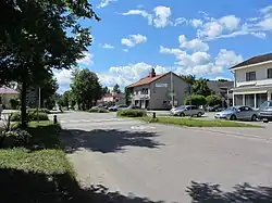
Joutsa is a municipality of Finland. It is located in the province of Western Finland and is part of the Central Finland region. Jyväskylä is located about 70 kilometres (43 mi) north of the Joutsa municipality.
The municipality has a population of 4,073 (30 September 2023)[2] and covers an area of 1,066.42 square kilometres (411.75 sq mi) of which 199.25 km2 (76.93 sq mi) is water.[1] The population density is 4.7 inhabitants per square kilometre (12/sq mi).
The municipality is unilingually Finnish. The municipality of Leivonmäki was consolidated with Joutsa on January 1, 2008.
Sahti culture in Joutsa is known by Joutsan sahti.
Geography
Neighbouring municipalities: Hartola, Hirvensalmi, Jyväskylä, Kangasniemi, Luhanka, Pertunmaa and Toivakka.
There are all together 192 lakes in Joutsa. The biggest lakes are Puula, Suontee and Jääsjärvi.[5]
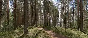
Leivonmäki National Park is located in Joutsa. At area is swamps, beaches and forest in esker.
Climate
| Climate data for Joutsa Savenaho (1991-2020 normals, extremes 1959-present) | |||||||||||||
|---|---|---|---|---|---|---|---|---|---|---|---|---|---|
| Month | Jan | Feb | Mar | Apr | May | Jun | Jul | Aug | Sep | Oct | Nov | Dec | Year |
| Record high °C (°F) | 7.5 (45.5) |
9.0 (48.2) |
14.9 (58.8) |
23.2 (73.8) |
29.6 (85.3) |
32.4 (90.3) |
33.0 (91.4) |
32.3 (90.1) |
24.8 (76.6) |
18.5 (65.3) |
11.5 (52.7) |
10.1 (50.2) |
33.0 (91.4) |
| Mean daily maximum °C (°F) | −4.4 (24.1) |
−3.8 (25.2) |
1.1 (34.0) |
7.7 (45.9) |
15.3 (59.5) |
19.5 (67.1) |
22.0 (71.6) |
19.9 (67.8) |
14.0 (57.2) |
6.5 (43.7) |
1.2 (34.2) |
−2.2 (28.0) |
8.1 (46.6) |
| Daily mean °C (°F) | −7.1 (19.2) |
−7.2 (19.0) |
−3.1 (26.4) |
2.6 (36.7) |
9.3 (48.7) |
13.9 (57.0) |
16.4 (61.5) |
14.6 (58.3) |
9.6 (49.3) |
3.8 (38.8) |
−0.7 (30.7) |
−4.3 (24.3) |
4.0 (39.2) |
| Mean daily minimum °C (°F) | −10 (14) |
−10.4 (13.3) |
−7 (19) |
−1.8 (28.8) |
3.6 (38.5) |
8.6 (47.5) |
11.7 (53.1) |
10.4 (50.7) |
6.1 (43.0) |
1.3 (34.3) |
−2.8 (27.0) |
−6.8 (19.8) |
0.2 (32.4) |
| Record low °C (°F) | −39.5 (−39.1) |
−37.0 (−34.6) |
−31.3 (−24.3) |
−21.9 (−7.4) |
−7.7 (18.1) |
−2.9 (26.8) |
1.2 (34.2) |
−1.8 (28.8) |
−6.0 (21.2) |
−15.9 (3.4) |
−24.5 (−12.1) |
−34.1 (−29.4) |
−39.5 (−39.1) |
| Average precipitation mm (inches) | 52 (2.0) |
41 (1.6) |
37 (1.5) |
37 (1.5) |
45 (1.8) |
70 (2.8) |
84 (3.3) |
71 (2.8) |
60 (2.4) |
72 (2.8) |
62 (2.4) |
61 (2.4) |
690 (27.2) |
| Average precipitation days (≥ 0.1 mm) | 20 | 17 | 15 | 12 | 13 | 15 | 15 | 15 | 16 | 19 | 21 | 20 | 198 |
| Source 1: FMI normals for Finland 1991-2020[6] | |||||||||||||
| Source 2: record highs and lows[7] | |||||||||||||
Villages
Media
Newspapers:
- Joutsan seutu is published in Joutsa and Luhanka.
- Itä-Häme
Twinnings
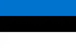 Tähtvere Parish, Estonia[8]
 Finspång, Sweden[9]
References
- 1 2 "Area of Finnish Municipalities 1.1.2018" (PDF). National Land Survey of Finland. Retrieved 30 January 2018.
- 1 2 "Preliminary population statistics 2023, September". StatFin. Statistics Finland. Retrieved 26 October 2023.
- ↑ "Demographic Structure by area as of 31 December 2022". Statistics Finland's PX-Web databases. Statistics Finland. Retrieved 6 September 2023.
- ↑ "Population according to age (1-year) and sex by area and the regional division of each statistical reference year, 2003–2020". StatFin. Statistics Finland. Retrieved 2 May 2021.
- ↑ "Joutsa". Järviwiki. Finland's Environmental Administration. 2012. Retrieved 27 February 2012.
- ↑ "FMI normals".
{{cite web}}: CS1 maint: url-status (link) - ↑ "FMI open data". FMI. Retrieved 4 January 2024.
{{cite web}}: CS1 maint: url-status (link) - ↑ "Suomen kuntien ystävyyskunnat" (in Finnish). Embassy of Finland in Estonia. Retrieved 7 May 2012.
- ↑ "Ystävyyskunnat" (PDF) (in Finnish). Pohjola-Norden. Retrieved 7 May 2012.
External links
![]() Media related to Joutsa at Wikimedia Commons
Media related to Joutsa at Wikimedia Commons
- Municipality of Joutsa – Official website, finnish
Places adjacent to Joutsa | ||||||||||||||||
|---|---|---|---|---|---|---|---|---|---|---|---|---|---|---|---|---|
| ||||||||||||||||
| Municipalities | ||
|---|---|---|
| Former municipalities | ||