Kimitoön
Kimitoön – Kemiönsaari | |
|---|---|
Municipality | |
| Kimitoöns kommun Kemiönsaaren kunta | |
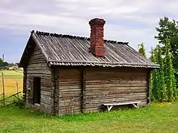 An old sauna, Sagalund outdoor museum, Kimito, Finland | |
 Flag  Coat of arms | |
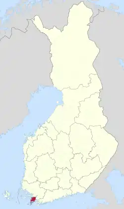 Location of Kimitoön in Finland | |
| Coordinates: 60°10′N 022°44′E / 60.167°N 22.733°E | |
| Country | |
| Region | Southwest Finland |
| Sub-region | Åboland–Turunmaa sub-region |
| Charter | 2009 |
| Government | |
| • Municipal manager | Erika Strandberg |
| Area (2018-01-01)[1] | |
| • Total | 2,800.99 km2 (1,081.47 sq mi) |
| • Land | 686.91 km2 (265.22 sq mi) |
| • Water | 2,113.94 km2 (816.20 sq mi) |
| • Rank | 123rd largest in Finland |
| Population (2023-09-30)[2] | |
| • Total | 6,468 |
| • Rank | 142nd largest in Finland |
| • Density | 9.42/km2 (24.4/sq mi) |
| Population by native language | |
| • Swedish | 67.1% (official) |
| • Finnish | 29.7% |
| • Others | 3.2% |
| Population by age | |
| • 0 to 14 | 11.9% |
| • 15 to 64 | 53.3% |
| • 65 or older | 34.8% |
| Time zone | UTC+02:00 (EET) |
| • Summer (DST) | UTC+03:00 (EEST) |
| Website | www.kimitoon.fi |
Kimitoön (Finnish: Kemiönsaari) is a municipality and island of Finland. It was created on 1 January 2009, when the municipalities of Dragsfjärd, Kimito and Västanfjärd were consolidated into a single municipality.
The municipality is located in the Archipelago Sea in the Southwest Finland region. The municipality has a population of 6,468 (30 September 2023)[2] and covers an area of 2,800.99 square kilometres (1,081.47 sq mi) of which 2,113.94 km2 (816.20 sq mi) is water.[1] The population density is 9.42 inhabitants per square kilometre (24.4/sq mi). Actual island is the largest coastal island of Finland with the area of 524 square kilometres (202 sq mi). It is situated in the Southwest Finland region in Western Finland province. The island has a population of 7,500 divided between the two municipalities: Kimitoön and Salo of which Salo is mostly located on the mainland. Kimitoön is bilingual with the majority speaking Swedish and a minority Finnish as their native language.
Politics
Results of the 2015 Finnish parliamentary election in Kimitoön:[5]
- Swedish People's Party 49.6%
- Social Democratic Party 13.0%
- Left Alliance 9.7%
- True Finns 6.7%
- Centre Party 10.4%
- National Coalition Party 5.4%
- Green League 3.8%
- Christian Democrats 0.8%
- Other parties 0.6%
Gallery
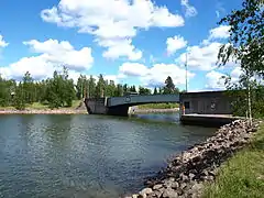 Strömma Canal
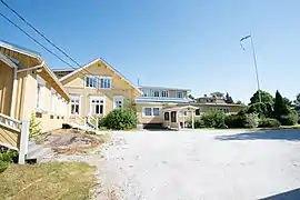 Restaurant Hotel Villa Felix
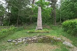 The Obelisk of Kimito Church
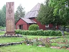 Västanfjärd Old Church
See also
References
- 1 2 "Area of Finnish Municipalities 1.1.2018" (PDF). National Land Survey of Finland. Retrieved 30 January 2018.
- 1 2 "Preliminary population statistics 2023, September". StatFin. Statistics Finland. Retrieved 26 October 2023.
- ↑ "Demographic Structure by area as of 31 December 2022". Statistics Finland's PX-Web databases. Statistics Finland. Retrieved 6 September 2023.
- ↑ "Population according to age (1-year) and sex by area and the regional division of each statistical reference year, 2003–2020". StatFin. Statistics Finland. Retrieved 2 May 2021.
- ↑ "Kemiönsaari, tulokset puolueittain". tulospalvelu.vaalit.fi.
External links
![]() Media related to Kimitoön at Wikimedia Commons
Media related to Kimitoön at Wikimedia Commons
- Municipality of Kimitoön – Official website (in Swedish and Finnish)
| Municipalities |  | |
|---|---|---|
| Former municipalities |
| |