Kustavi
Gustavs | |
|---|---|
Municipality | |
| Kustavin kunta Gustavs kommun | |
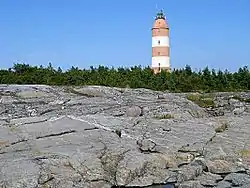 The Isokari Lighthouse in Kustavi | |
 Coat of arms | |
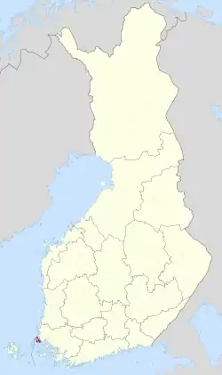 Location of Kustavi in Finland | |
| Coordinates: 60°32.8′N 021°21.5′E / 60.5467°N 21.3583°E | |
| Country | |
| Region | Southwest Finland |
| Sub-region | Vakka-Suomi sub-region |
| Charter | 1874 |
| Named for | Gustav III[1] |
| Government | |
| • Municipal manager | Veijo Katara |
| Area (2018-01-01)[2] | |
| • Total | 770.15 km2 (297.36 sq mi) |
| • Land | 165.84 km2 (64.03 sq mi) |
| • Water | 603.45 km2 (232.99 sq mi) |
| • Rank | 273rd largest in Finland |
| Population (2023-09-30)[3] | |
| • Total | 942 |
| • Rank | 299th largest in Finland |
| • Density | 5.68/km2 (14.7/sq mi) |
| Population by native language | |
| • Finnish | 94.7% (official) |
| • Swedish | 1.6% |
| • Others | 3.7% |
| Population by age | |
| • 0 to 14 | 9% |
| • 15 to 64 | 51.8% |
| • 65 or older | 39.2% |
| Time zone | UTC+02:00 (EET) |
| • Summer (DST) | UTC+03:00 (EEST) |
| Website | www.kustavi.fi |
Kustavi (Finnish pronunciation: [ˈkustɑʋi]; Swedish: Gustavs) is a municipality of Finland. It is in the province of Western Finland and is part of the Southwest Finland region. The municipality has a population of 942 (30 September 2023),[3] which makes it the smallest municipality in southwest Finland in terms of population. It covers an area of 770.15 square kilometres (297.36 sq mi) of which 603.45 km2 (232.99 sq mi) is water.[2] The population density is 5.68 per square kilometre (14.7/sq mi).
There are over 2,000 isles within the municipal area. The municipality is a very popular summer resort and contains over 2,800 summer cottages. The population increases tenfold during the summer months. The larger events are Volter Kilpi literature week in July and Salmon market (Lohimarkkinat) in August. The basic services in the municipality include three groceries, a liquor store, a library and a bank. There are two ferry connections to Brändö and Iniö.
The municipality is unilingually Finnish even though it is located adjacent to the Swedish speaking Åland-region. The municipality is named after King Gustav III of Sweden.[1]
Climate
| Climate data for Kustavi Isokari (1991–2020 normals, extremes 1995- present) | |||||||||||||
|---|---|---|---|---|---|---|---|---|---|---|---|---|---|
| Month | Jan | Feb | Mar | Apr | May | Jun | Jul | Aug | Sep | Oct | Nov | Dec | Year |
| Record high °C (°F) | 7.9 (46.2) |
6.5 (43.7) |
8.6 (47.5) |
17.9 (64.2) |
26.1 (79.0) |
28.2 (82.8) |
29.0 (84.2) |
28.0 (82.4) |
22.7 (72.9) |
16.6 (61.9) |
12.6 (54.7) |
9.3 (48.7) |
29.0 (84.2) |
| Daily mean °C (°F) | −1.5 (29.3) |
−2.9 (26.8) |
−0.7 (30.7) |
2.8 (37.0) |
7.7 (45.9) |
12.7 (54.9) |
16.8 (62.2) |
16.9 (62.4) |
12.9 (55.2) |
7.8 (46.0) |
3.6 (38.5) |
0.9 (33.6) |
6.4 (43.5) |
| Record low °C (°F) | −24.9 (−12.8) |
−22.3 (−8.1) |
−18.4 (−1.1) |
−10.1 (13.8) |
−1.3 (29.7) |
4.1 (39.4) |
9.6 (49.3) |
5.9 (42.6) |
4.1 (39.4) |
−4.0 (24.8) |
−10.7 (12.7) |
−21.0 (−5.8) |
−24.9 (−12.8) |
| Source 1: FMI climatological normals for Finland 1991-2020[6] | |||||||||||||
| Source 2: Record highs and lows 1995- present[7] | |||||||||||||
References
- 1 2 Tietoa Kustavista (in Finnish)
- 1 2 "Area of Finnish Municipalities 1.1.2018" (PDF). National Land Survey of Finland. Retrieved 30 January 2018.
- 1 2 "Preliminary population statistics 2023, September". StatFin. Statistics Finland. Retrieved 26 October 2023.
- ↑ "Demographic Structure by area as of 31 December 2022". Statistics Finland's PX-Web databases. Statistics Finland. Retrieved 6 September 2023.
- ↑ "Population according to age (1-year) and sex by area and the regional division of each statistical reference year, 2003–2020". StatFin. Statistics Finland. Retrieved 2 May 2021.
- ↑ "FMI normals 1991-2020". fmi.fi. Retrieved 23 April 2023.
- ↑ "FMI open data". FMI. Retrieved 21 May 2023.
External links
![]() Media related to Kustavi at Wikimedia Commons
Media related to Kustavi at Wikimedia Commons
- Municipality of Kustavi – Official website
Places adjacent to Kustavi | ||||||||||||||||
|---|---|---|---|---|---|---|---|---|---|---|---|---|---|---|---|---|
| ||||||||||||||||
| Municipalities |  | |
|---|---|---|
| Former municipalities |
| |