Křídla | |
|---|---|
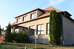 Primary school and kindergarten | |
 Flag  Coat of arms | |
 Křídla Location in the Czech Republic | |
| Coordinates: 49°31′38″N 16°7′21″E / 49.52722°N 16.12250°E | |
| Country | |
| Region | Vysočina |
| District | Žďár nad Sázavou |
| First mentioned | 1376 |
| Area | |
| • Total | 4.54 km2 (1.75 sq mi) |
| Elevation | 583 m (1,913 ft) |
| Population (2023-01-01)[1] | |
| • Total | 376 |
| • Density | 83/km2 (210/sq mi) |
| Time zone | UTC+1 (CET) |
| • Summer (DST) | UTC+2 (CEST) |
| Postal code | 592 31 |
| Website | www |
Křídla is a municipality and village in Žďár nad Sázavou District in the Vysočina Region of the Czech Republic. It has about 400 inhabitants.
Křídla lies approximately 14 kilometres (9 mi) east of Žďár nad Sázavou, 42 km (26 mi) east of Jihlava, and 138 km (86 mi) south-east of Prague.
References
Wikimedia Commons has media related to Křídla.
This article is issued from Wikipedia. The text is licensed under Creative Commons - Attribution - Sharealike. Additional terms may apply for the media files.