Křešín | |
|---|---|
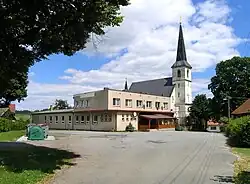 Restaurant and Church of Saint Bartholomew | |
 Křešín Location in the Czech Republic | |
| Coordinates: 49°34′54″N 15°2′38″E / 49.58167°N 15.04389°E | |
| Country | |
| Region | Vysočina |
| District | Pelhřimov |
| First mentioned | 1318 |
| Area | |
| • Total | 11.10 km2 (4.29 sq mi) |
| Elevation | 512 m (1,680 ft) |
| Population (2023-01-01)[1] | |
| • Total | 185 |
| • Density | 17/km2 (43/sq mi) |
| Time zone | UTC+1 (CET) |
| • Summer (DST) | UTC+2 (CEST) |
| Postal codes | 394 24, 395 01 |
| Website | www |
Křešín is a municipality and village in Pelhřimov District in the Vysočina Region of the Czech Republic. It has about 200 inhabitants.
Křešín lies approximately 22 kilometres (14 mi) north-west of Pelhřimov, 45 km (28 mi) north-west of Jihlava, and 72 km (45 mi) south-east of Prague.
Administrative parts
Villages and hamlets of Blažnov, Čeněnice, Kramolín and Mohelnice administrative parts of Křešín.
References
Wikimedia Commons has media related to Křešín (Pelhřimov District).
This article is issued from Wikipedia. The text is licensed under Creative Commons - Attribution - Sharealike. Additional terms may apply for the media files.