Kairouan
قيروان | |
|---|---|
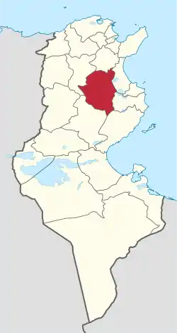
 Map of Tunisia with Kairouan highlighted | |
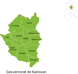
 Subdivisions of Kairouan Governorate | |
| Coordinates: 35°40′N 10°06′E / 35.667°N 10.100°E | |
| Country | |
| Created | 21 June 1956 |
| Capital | Kairouan |
| Government | |
| • Governor | Vacant |
| Area | |
| • Total | 6,712 km2 (2,592 sq mi) |
| • Rank | Ranked 9th of 24 |
| Population (2014) | |
| • Total | 570,559 |
| • Rank | Ranked 5th of 24 |
| • Density | 85/km2 (220/sq mi) |
| Time zone | UTC+01 (CET) |
| Postal prefix | xx |
| ISO 3166 code | TN-41 |
Kairouan Governorate (Tunisian Arabic: ولاية قيروان Wilāyat Qiyrwān; French: Gouvernorat de Kairouan) is one of the twenty-four governorates of Tunisia. It is landlocked and in the centre-east of the country. It covers an area of 6,712 km2 and has a population of 570,559 (2014 census). The narrower province of Sousse borders it to the east, the nearest coastline[1] The capital is Kairouan. Lowland parts of the province are semi-arid, experiencing in most years light rains in the winter months and scant rainfall in other months but higher parts attract relief precipitation in and around the Djebel Zhagdoud and a large part of the Djebel Serj national parks, in the north-east of the province which are geologically outcrops of the Dorsal Atlas mountains in the province to the north.
Administrative divisions
The Kairouan Governorate is divided into eleven delegations (mutamadiyat), listed below with their populations at the 2004 and 2014 Censuses,[2] and further sub-divided into sectors (imada).
| Delegation | Area in km2 | Population 2004 Census | Population 2014 Census |
|---|---|---|---|
| Alaâ | 361 | 31,773 | 28,991 |
| Bou Hajla | 690 | 70,589 | 72,371 |
| Chebika | 513 | 33,889 | 35,308 |
| Echrarda | 330 | 25,903 | 27,518 |
| Haffouz | 611 | 43,792 | 40,066 |
| Hajeb El Ayoun | 589 | 35,403 | 36,137 |
| Kairouan Nord | 251 | 83,794 | 96,781 |
| Kairouan Sud | 520 | 80,444 | 93,101 |
| Nasrallah | 685 | 37,112 | 33,789 |
| Oueslatia | 915 | 36,195 | 34,452 |
| Sbikha | 1,069 | 67,315 | 71,922 |
Twelve municipalities are included within Kairouan Governorate:
| Code | Municipality | Population (2014)[3] |
|---|---|---|
| 4111 | Kairouan | 139,070 |
| 4112 | Chebika | 2,921 |
| 4113 | Sbikha | 8,036 |
| 4114 | Oueslatia | 9,006 |
| 4115 | Aïn Djeloula | 1,757 |
| 4116 | Haffouz | 8,429 |
| 4117 | Alaâ | 3,276 |
| 4118 | Hajeb El Ayoun | 10,621 |
| 4119 | Nasrallah | 5,012 |
| 4120 | Menzel Mehiri | 3,870 |
| 4121 | Echrarda | 1,705 |
| 4122 | Bou Hajla | 7,828 |
Nature reserves
References
- ↑ (in French)Census 2014 (National Institute of Statistics) Archived 2014-10-29 at the Wayback Machine
- ↑ Institut National de la Statistique Tunisie (web).
- ↑ Recensement Général de la Population et de l'Habitat 2014 – Population, logements et ménages par commune et arrondissement [Census 2014 results – population, accommodation and households per municipality and delegation] (Report) (in French). National Institute of Statistics. 1 April 2015. Retrieved 18 February 2016.
- ↑ "Reserve Naturelle" (PDF). www.onagri.nat.tn. Retrieved 23 April 2018.