Kamiina (上伊那郡, Kamiina-gun) is a district located in southern Nagano Prefecture, Japan.
As of May 2008, the district has an estimated population of 86,453 with a density of 168 persons per km2. The total area is 514.55 km2.
On the other hand, if the cities of Ina and Komagane were included, the area will be known as the Kamiina Region.
Municipalities
The district consists of three towns and three villages:
- Iijima[lower-alpha 1]
- Minamiminowa[lower-alpha 2]
- Minowa[lower-alpha 1]
- Miyada[lower-alpha 2]
- Nakagawa[lower-alpha 2]
- Tatsuno[lower-alpha 1]
- Notes
History

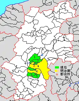
Map showing original extent of Kamiina District in Nagano Prefecture:
* yellow - areas formerly within the district borders during the early Meiji period
* yellow - areas formerly within the district borders during the early Meiji period
- Tatsuno-machi
- Minowa-machi
- Iijima-machi
- Minamiminowa-mura
- Nakagawa-mura
- Miyada-mura

Colored areas are in this district.
- January 4, 1879 - Ina District was split off into Kamiina and Shimoina Districts during the early Meiji period establishment of the municipalities system, which initially consisted of 2 towns and 26 villages. Its district headquarters was located at the village of at Ina.
District Timeline
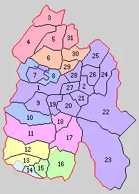
- April 1, 1954 - The towns of Ina merged with the villages of Tomigata, Midori, Shura, Higashiharuchika, and Nishiminowa to form the city of Ina.
- July 1, 1954 - The towns of Akaho and Miyada merged with the villages of Ina and Nakazawa to form the city of Komagane.
- January 1, 1955 - The town of Nakaminowa merged with the villages of Minowa and Higashiminowa to form the town of Minowa.
- April 1, 1955-The town of Tatsuno merged with the village of Asahi to form the new town of Tatsuno.
- September 30, 1956:
- The town of Tatsuno absorbed the village of Kawashima.
- The town of Takatō merged with the villages of Nagafuji and Miyoshi to form the new town of Takatō.
- The town of Iijima merged with the village of Nanakubo to form the new town of Iijima.
- The village of Miyada broke off from the city of Komagane.
- The town of Kamikatado merged with the village of Oshima from Shimoina District to form the town of Matsukawa in Shimoina District.
- April 1, 1958 - The town of Takatō absorbed the village of Fujisawa.
- August 1, 1958 - The villages of Nanko and Katado merged to form the village of Nakagawa.
- April 1, 1959 - The villages of Inari and Miwa merged to form the town of Hase.
- March 31, 1961 - The town of Tatsuno absorbed the village of Ono.
- April 1, 1965 - The town of Takatō absorbed the village of Kawanan.
- April 1, 1965 - The city of Ina absorbed the village of Nishiharuchika.
Recent mergers
This article is issued from Wikipedia. The text is licensed under Creative Commons - Attribution - Sharealike. Additional terms may apply for the media files.