Kammern im Liesingtal | |
|---|---|
 | |
 Coat of arms | |
 Kammern im Liesingtal Location within Austria | |
| Coordinates: 47°22′48″N 14°54′00″E / 47.38000°N 14.90000°E | |
| Country | Austria |
| State | Styria |
| District | Leoben |
| Government | |
| • Mayor | Karl Dobnigg (SPÖ) |
| Area | |
| • Total | 58.86 km2 (22.73 sq mi) |
| Elevation | 664 m (2,178 ft) |
| Population (2018-01-01)[2] | |
| • Total | 1,600 |
| • Density | 27/km2 (70/sq mi) |
| Time zone | UTC+1 (CET) |
| • Summer (DST) | UTC+2 (CEST) |
| Postal code | 8772, 8773 |
| Area code | 03844 |
| Vehicle registration | LN |
| Website | www.kammern-liesingtal.at |
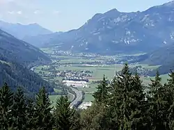
Lower valley
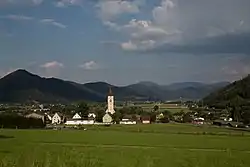
Kammern im Liesingtal is a municipality in the district of Leoben in the Austrian state of Styria.
Geography
Kammern im Liesingtal lies in the Liesing valley in northeast Styria, in the center of upper Styria.
References
- ↑ "Dauersiedlungsraum der Gemeinden Politischen Bezirke und Bundesländer - Gebietsstand 1.1.2018". Statistics Austria. Retrieved 10 March 2019.
- ↑ "Einwohnerzahl 1.1.2018 nach Gemeinden mit Status, Gebietsstand 1.1.2018". Statistics Austria. Retrieved 9 March 2019.

Parish church St. John the Baptist
This article is issued from Wikipedia. The text is licensed under Creative Commons - Attribution - Sharealike. Additional terms may apply for the media files.