Kamo
加茂町 | |
|---|---|
Former municipality | |
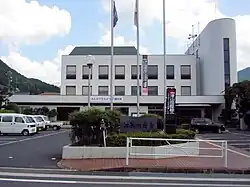
 Former Kamo town hall | |
 Kamo Location in Japan | |
| Coordinates: 35°10′41.4″N 134°3′14.5″E / 35.178167°N 134.054028°E | |
| Country | Japan |
| Region | Chūgoku |
| Prefecture | Okayama Prefecture |
| District | Tomata |
| Merged | February 28, 2005 (now part of Tsuyama) |
| Area | |
| • Total | 159.27 km2 (61.49 sq mi) |
| Population (2003) | |
| • Total | 5,311 |
| • Density | 33.35/km2 (86.4/sq mi) |
| Time zone | UTC+09:00 (JST) |
| Symbols | |
| Bird | Japanese bush-warbler |
| Flower | Satsuki azalea |
| Tree | Chamaecyparis obtusa |
Kamo (加茂町, Kamo-chō) was a town located in Tomata District, Okayama Prefecture, Japan.
As of 2003, the town had an estimated population of 5,311 and a density of 33.35 persons per km2. The total area was 159.27 km2.
On February 28, 2005, Kamo, along with the village of Aba (also from Tomata District), the town of Shōboku (from Katsuta District), and the town of Kume (from Kume District), was merged into the expanded city of Tsuyama and no longer exists as an independent municipality.
Massacre
On 21 May 1938, the town became the scene of the deadliest shooting by a lone gunman in Japanese history. A 21-year-old man murdered 30 people (including his own grandmother) and wounded three others before killing himself.[1]
Geography
Adjoining municipalities
Education
- Kamo Elementary School
- Kamo Junior High School
Transportation
Railways
Road
References
- ↑ "理不尽な凶行、遺族ら「無念」…秋葉原無差別殺傷事件:社会:スポーツ報知". hochi.yomiuri.co.jp. Archived from the original on 13 June 2008. Retrieved 15 May 2022.
External links
- Official website of Tsuyama in Japanese (some English content)
This article is issued from Wikipedia. The text is licensed under Creative Commons - Attribution - Sharealike. Additional terms may apply for the media files.