Katzelsdorf | |
|---|---|
 | |
 Coat of arms | |
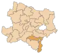
 Katzelsdorf Location within Austria | |
| Coordinates: 47°46′44″N 16°16′25″E / 47.77889°N 16.27361°E | |
| Country | Austria |
| State | Lower Austria |
| District | Wiener Neustadt-Land |
| Government | |
| • Burgermeisterin | Hannelore Handler-Woltran (ÖVP) |
| Area | |
| • Total | 16.26 km2 (6.28 sq mi) |
| Elevation | 273 m (896 ft) |
| Population (2018-01-01)[2] | |
| • Total | 3,257 |
| • Density | 200/km2 (520/sq mi) |
| Time zone | UTC+1 (CET) |
| • Summer (DST) | UTC+2 (CEST) |
| Postal code | 2801 |
| Area code | 02622 |
| Vehicle registration | WB |
| Website | www.katzelsdorf.at |
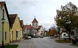
Katzelsdorf is a municipality in the district of Wiener Neustadt-Land in Lower Austria, Austria. It is situated at the foot of the Rosalia Mountains, on the river Leitha, 5 km southeast of Wiener Neustadt.
Population
| Year | Pop. | ±% |
|---|---|---|
| 1869 | 871 | — |
| 1880 | 881 | +1.1% |
| 1890 | 977 | +10.9% |
| 1900 | 1,076 | +10.1% |
| 1910 | 1,131 | +5.1% |
| 1923 | 1,270 | +12.3% |
| 1934 | 1,305 | +2.8% |
| 1939 | 1,347 | +3.2% |
| 1951 | 1,237 | −8.2% |
| 1961 | 1,342 | +8.5% |
| 1971 | 1,648 | +22.8% |
| 1981 | 1,883 | +14.3% |
| 1991 | 2,294 | +21.8% |
| 2001 | 2,827 | +23.2% |
| 2011 | 3,201 | +13.2% |
References
- ↑ "Dauersiedlungsraum der Gemeinden Politischen Bezirke und Bundesländer - Gebietsstand 1.1.2018". Statistics Austria. Retrieved 10 March 2019.
- ↑ "Einwohnerzahl 1.1.2018 nach Gemeinden mit Status, Gebietsstand 1.1.2018". Statistics Austria. Retrieved 9 March 2019.
External links
- Katzelsdorf website
- Zinnfigurenwelt Archived 2007-06-22 at the Wayback Machine
This article is issued from Wikipedia. The text is licensed under Creative Commons - Attribution - Sharealike. Additional terms may apply for the media files.