Kawaguchi
川口町 | |
|---|---|
Former municipality | |
 | |
 Flag  Emblem | |
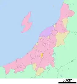 Location of Kawaguchi in Niigata Prefecture | |
| Country | Japan |
| Region | Hokuriku |
| Prefecture | Niigata Prefecture |
| District | Kitauonuma District |
| Merged | March 31, 2010 (now part of Nagaoka) |
| Area | |
| • Total | 50.03 km2 (19.32 sq mi) |
| Population (2010) | |
| • Total | 4,801 |
| Time zone | UTC+09:00 (JST) |
| Symbols | |
| Flower | Phlox subulata |
| Tree | Cherry blossom |
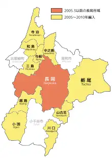
10 municipalities merged into Nagaoka City
Kawaguchi (川口町, Kawaguchi-machi) was a town located in Kitauonuma District, Niigata Prefecture, Japan.
As of 2003, the town had an estimated population of 5,549 and a density of 110.91 persons per km². The total area was 50.03 km².
During the 2004 Chūetsu earthquake, Kawaguchi was the only town to report the maximum value of 7 on the Japan Meteorological Agency seismic intensity scale.
On March 31, 2010, Kawaguchi was merged into the expanded city of Nagaoka.[1]
Transportation
Railway
.svg.png.webp) JR East - Jōetsu Line
JR East - Jōetsu Line
- JR East - Iiyama Line
- Echigo-Kawaguchi
Highway
 Kan-etsu Expressway – Echigo-Kawaguchi IC/SA
 National Route 17
 National Route 117
References
- ↑ "Archived copy". Archived from the original on 2013-10-04. Retrieved 2010-04-02.
{{cite web}}: CS1 maint: archived copy as title (link)
See also
37°16′N 138°52′E / 37.267°N 138.867°E
Dissolved municipalities of | |||||||
|---|---|---|---|---|---|---|---|
| Niigata |
| ||||||
| Murakami |
| ||||||
| Tainai |
| ||||||
| Shibata |
| ||||||
| Agano |
| ||||||
| Gosen |
| ||||||
| Aga |
| ||||||
| Tsubame |
| ||||||
| Sanjō |
| ||||||
| Nagaoka |
| ||||||
| Kashiwazaki |
| ||||||
| Tōkamachi |
| ||||||
| Uonuma |
| ||||||
| Minamiuonuma |
| ||||||
| Jōetsu |
| ||||||
| Myōkō (Arai) |
| ||||||
| Itoigawa |
| ||||||
| Sado |
| ||||||
This article is issued from Wikipedia. The text is licensed under Creative Commons - Attribution - Sharealike. Additional terms may apply for the media files.