Kirnberg an der Mank | |
|---|---|
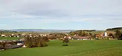 View from south | |
 Coat of arms | |
 Kirnberg an der Mank Location within Austria | |
| Coordinates: 48°4′N 15°19′E / 48.067°N 15.317°E | |
| Country | Austria |
| State | Lower Austria |
| District | Melk |
| Government | |
| • Mayor | Ferdinand Neuhauser |
| Area | |
| • Total | 17.67 km2 (6.82 sq mi) |
| Elevation | 341 m (1,119 ft) |
| Population (2018-01-01)[2] | |
| • Total | 1,070 |
| • Density | 61/km2 (160/sq mi) |
| Time zone | UTC+1 (CET) |
| • Summer (DST) | UTC+2 (CEST) |
| Postal code | 3241 |
| Area code | 02755 |
| Website | www.kirnberg.at |
Kirnberg an der Mank is a town in the district of Melk in the Austrian state of Lower Austria.
Population
| Year | Pop. | ±% |
|---|---|---|
| 1971 | 963 | — |
| 1981 | 918 | −4.7% |
| 1991 | 987 | +7.5% |
| 2001 | 1,009 | +2.2% |
References
- ↑ "Dauersiedlungsraum der Gemeinden Politischen Bezirke und Bundesländer - Gebietsstand 1.1.2018". Statistics Austria. Retrieved 10 March 2019.
- ↑ "Einwohnerzahl 1.1.2018 nach Gemeinden mit Status, Gebietsstand 1.1.2018". Statistics Austria. Retrieved 9 March 2019.
This article is issued from Wikipedia. The text is licensed under Creative Commons - Attribution - Sharealike. Additional terms may apply for the media files.