Koulandougou | |
|---|---|
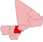
 Koulandougou Location in Mali | |
| Coordinates: 13°9′21″N 5°17′57″W / 13.15583°N 5.29917°W | |
| Country | |
| Region | Ségou Region |
| Cercle | Bla Cercle |
| Population (2009 census)[1] | |
| • Total | 4,293 |
| Time zone | UTC+0 (GMT) |
Koulandougou is a commune in the Cercle of Bla in the Ségou Region of Mali. The administrative center (chef-lieu) is the village of N'Toba.
References
- ↑ Resultats Provisoires RGPH 2009 (Région de Ségou) (PDF) (in French), République de Mali: Institut National de la Statistique, archived from the original (PDF) on 2011-07-22.
External links
- Plan de Sécurite Alimentaire Commune Rurale de Koulandougou 2008-2012 (PDF) (in French), Commissariat à la Sécurité Alimentaire, République du Mali, USAID-Mali, 2007.
This article is issued from Wikipedia. The text is licensed under Creative Commons - Attribution - Sharealike. Additional terms may apply for the media files.