Kunnukara | |
|---|---|
town | |
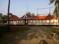
 Kootala Bhagavathy Temple | |
| Nickname: Land of hill | |
| Coordinates: 10°9′0″N 76°18′0″E / 10.15000°N 76.30000°E | |
| Country | |
| State | Kerala |
| District | Ernakulam |
| City UA | Kochi |
| Government | |
| • Body | Kunnukara Panchayat North Paravur Taluk |
| Languages | |
| • Official | Malayalam, English |
| Time zone | UTC+5:30 (IST) |
| PIN | 683578 |
| Telephone code | 0484 |
| Vehicle registration | KL-42 |
| Nearest city | North Paravur |
| Lok Sabha constituency | Ernakulam |
| Civic agency | Kunnukara Panchayat |
| Climate | moderate (Köppen) |
| Website | www |
Kunnukara is a census town and panchayat in Paravur Taluk of Ernakulam district, Kerala, India. The village is situated on the airport road connecting North Paravur (NH66) and Nedumbassery (NH544). North Paravur is the nearest town, 7 km from this village. Aluva (10 km) and Angamaly (12 km) are also near to Kunnukara. Its administrative headquarters is in Kunnukara Town itself. The Mini Civil Station has four hospitals, all the Govt. offices, a Khadi Unit Supermarkets etc.
History
Kunnukara panchayat was once part of Ayroor village union in Alengad taluk, later Alengad merged with N.Paravur and Kunnukara became panchayat. This place was under Kingdom of Cochin. During Mysorean invasion of Kerala, Tipu Sultan travelled through Manjaly via Kunnukara.
Geography
Kunnukara is surrounded by Periyar river in south, Chalakudy river in north and Manjaly Canal in its centre and west, Kunnukara is the part of Kerala backwaters. The surrounding areas are Chengamand panchayat in east, Thrissur district - Kuzhur panchayat in North, Puthenvelikkara panchayat in west and Karumallore panchayat to the south. Kunnukara is considered to be the rice grain of Paravur. The main source of income in the panchayat comes from agriculture. Different types of cultivations are there in the panchayat. Brick construction is a major industry in the panchayat.
Civic Administration
Kunnukara belongs to Parakkadav block panchayat. These are the wards or places in Kunnukara: Aduvassery, Kuttipuzha, Chalakka, Ayroor, Vayalkara, Kuthiathode.
