Kuratau | |
|---|---|
Rural settlement | |
 Kuratau Beach | |
| Coordinates: 38°53′36″S 175°46′11″E / 38.893347°S 175.769783°E | |
| Country | New Zealand |
| Region | Waikato region |
| District | Taupō District |
| Ward | Turangi-Tongariro Ward |
| Community | Turangi-Tongariro Community |
| Electorates | |
| Government | |
| • Territorial Authority | Taupō District Council |
| • Regional council | Waikato Regional Council |
| Area | |
| • Total | 4.50 km2 (1.74 sq mi) |
| Population (June 2023)[2] | |
| • Total | 120 |
| • Density | 27/km2 (69/sq mi) |
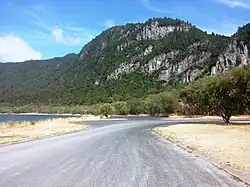
Kuratau is a small village north of Pukawa, on the western side of New Zealand's Lake Taupō.[3]
The Kuratau Power Station was built on the Kuratau River near the town and completed in 1962.
The local Poukura Marae and Parekawa meeting house is a meeting place of the Ngāti Tūwharetoa hapū of Ngāti Parekāwa.[4][5]
Lake Taupō is eroding Kuratau's foreshore at an increasing rate.[6]
Demographics
Statistics New Zealand describes Kuratau as a rural settlement, which covers 4.50 km2 (1.74 sq mi)[1] and had an estimated population of 120 as of June 2023,[2] with a population density of 27 people per km2. The settlement is part of the larger Lake Taupo Bays statistical area.[7]
| Year | Pop. | ±% p.a. |
|---|---|---|
| 2006 | 87 | — |
| 2013 | 93 | +0.96% |
| 2018 | 93 | +0.00% |
| Source: [8] | ||
Kuratau had a population of 93 at the 2018 New Zealand census, unchanged since the 2013 census, and an increase of 6 people (6.9%) since the 2006 census. There were 60 households, comprising 48 males and 48 females, giving a sex ratio of 1.0 males per female. The median age was 64.8 years (compared with 37.4 years nationally), with 6 people (6.5%) aged under 15 years, 6 (6.5%) aged 15 to 29, 39 (41.9%) aged 30 to 64, and 45 (48.4%) aged 65 or older.
Ethnicities were 93.5% European/Pākehā, 6.5% Māori, and 6.5% other ethnicities. People may identify with more than one ethnicity.
Although some people chose not to answer the census's question about religious affiliation, 38.7% had no religion, 51.6% were Christian, and 3.2% had Māori religious beliefs.
Of those at least 15 years old, 27 (31.0%) people had a bachelor's or higher degree, and 12 (13.8%) people had no formal qualifications. The median income was $38,000, compared with $31,800 nationally. 18 people (20.7%) earned over $70,000 compared to 17.2% nationally. The employment status of those at least 15 was that 33 (37.9%) people were employed full-time, and 12 (13.8%) were part-time.[8]
Education
Kuratau School is a co-educational state primary school,[9][10] with a roll of 89 as of April 2023.[11][12]
References
- 1 2 "ArcGIS Web Application". statsnz.maps.arcgis.com. Retrieved 11 November 2022.
- 1 2 "Subnational population estimates (RC, SA2), by age and sex, at 30 June 1996-2023 (2023 boundaries)". Statistics New Zealand. Retrieved 25 October 2023. (regional councils); "Subnational population estimates (TA, SA2), by age and sex, at 30 June 1996-2023 (2023 boundaries)". Statistics New Zealand. Retrieved 25 October 2023. (territorial authorities); "Subnational population estimates (urban rural), by age and sex, at 30 June 1996-2023 (2023 boundaries)". Statistics New Zealand. Retrieved 25 October 2023. (urban areas)
- ↑ "Place name detail: Kuratau". New Zealand Gazetteer. New Zealand Geographic Board. Retrieved 13 November 2022.
- ↑ "Te Kāhui Māngai directory". tkm.govt.nz. Te Puni Kōkiri.
- ↑ "Māori Maps". maorimaps.com. Te Potiki National Trust.
- ↑ Mitchell, Charlie (25 March 2023). "The 'idyllic' community being eaten away by the electricity market". Stuff.
- ↑ 2018 Census place summary: Lake Taupo Bays
- 1 2 "Statistical area 1 dataset for 2018 Census". Statistics New Zealand. March 2020. 7013295.
- ↑ "Kuratau School Official School Website". kuratau.school.nz.
- ↑ "Kuratau School Ministry of Education School Profile". educationcounts.govt.nz. Ministry of Education.
- ↑ "New Zealand Schools Directory". New Zealand Ministry of Education. Retrieved 12 December 2022.
- ↑ "Kuratau School Education Review Office Report". ero.govt.nz. Education Review Office.