Létavértes | |
|---|---|
 Greek Catholic Church (2007) | |
 Flag  Coat of arms | |
 Létavértes | |
| Coordinates: 47°23′N 21°54′E / 47.383°N 21.900°E | |
| Country | |
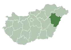
| County | Hajdú-Bihar |
| District | Derecske |
| Area | |
| • Total | 116.62 km2 (45.03 sq mi) |
| Population (2015) | |
| • Total | 7,061[1] |
| • Density | 60.6/km2 (157/sq mi) |
| Time zone | UTC+1 (CET) |
| • Summer (DST) | UTC+2 (CEST) |
| Postal code | 4281 |
| Area code | (+36) 52 |
| Website | www |
Létavértes (Romanian: Leta Mare) is a town in Hajdú-Bihar county, in the Northern Great Plain region of eastern Hungary.
Geography
It covers an area of 116.62 km2 (45 sq mi) and has a population of 7061 people (2015).[1]
International relations
Twin towns – Sister cities
Létavértes is twinned with:
 Săcueni, Romania
References
- 1 2 Gazetteer of Hungary, 1st January 2015. Hungarian Central Statistical Office. 3 September 2015
External links
Wikimedia Commons has media related to Létavértes.
- Official website in Hungarian
| Towns (2) |
| |
|---|---|---|
| Large villages (2) | ||
| Villages (9) | ||
| City with county rights |
|   |
|---|---|---|
| Towns | ||
| Large villages | ||
| Villages |
| |
| Other topics |
| |
47°23′N 21°54′E / 47.383°N 21.900°E
This article is issued from Wikipedia. The text is licensed under Creative Commons - Attribution - Sharealike. Additional terms may apply for the media files.