Püspökladány | |
|---|---|
 | |
 Flag  Coat of arms | |
 Püspökladány | |
| Coordinates: 47°19′N 21°7′E / 47.317°N 21.117°E | |
| Country | |
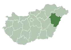
| County | Hajdú-Bihar |
| District | Püspökladány |
| Area | |
| • Total | 186.95 km2 (72.18 sq mi) |
| Population (2001) | |
| • Total | 16,126 |
| • Density | 85.79/km2 (222.2/sq mi) |
| Time zone | UTC+1 (CET) |
| • Summer (DST) | UTC+2 (CEST) |
| Postal code | 4150 |
| Area code | (+36) 54 |
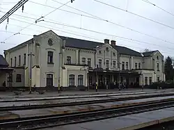
Püspökladány (pronounced [ˈpyʃpøklɒdaːɲ]) is the sixth largest town of Hajdú-Bihar county in North Eastern Hungary with a population of approximately 16,000 people. It is located southwest of Debrecen at the juncture of three regions: Sárrét, Hortobágy and Nagykunság. It is an important transportation hub at the junction of national highway 4 from Budapest to Záhony, and national highway No. 42 from Romania to Biharkeresztes. The town is served by four different rail lines.
Twin towns – sister cities
Püspökladány is twinned with:[1]
 Fischamend, Austria
 Ghindari, Romania
 Hämeenlinna, Finland
 Hattem, Netherlands
 Krasnystaw, Poland
References
- ↑ "Testvérvárosok". puspokladany.hu (in Hungarian). Püspökladány. Retrieved 2021-03-28.
External links
Wikimedia Commons has media related to Püspökladány.
| Towns (2) |
| |
|---|---|---|
| Large villages (3) | ||
| Villages (7) | ||
| City with county rights |
|   |
|---|---|---|
| Towns | ||
| Large villages | ||
| Villages |
| |
| Other topics |
| |
This article is issued from Wikipedia. The text is licensed under Creative Commons - Attribution - Sharealike. Additional terms may apply for the media files.