La Haye-du-Puits | |
|---|---|
Part of La Haye | |
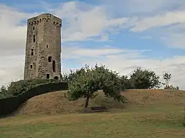 The ruined keep of La Haye-du-Puits castle | |
Location of La Haye-du-Puits | |
 La Haye-du-Puits  La Haye-du-Puits | |
| Coordinates: 49°17′27″N 1°32′28″W / 49.2908°N 1.5411°W | |
| Country | France |
| Region | Normandy |
| Department | Manche |
| Arrondissement | Coutances |
| Canton | Créances |
| Commune | La Haye |
| Area 1 | 5.25 km2 (2.03 sq mi) |
| Population (2019)[1] | 1,462 |
| • Density | 280/km2 (720/sq mi) |
| Demonym | Haytillons |
| Time zone | UTC+01:00 (CET) |
| • Summer (DST) | UTC+02:00 (CEST) |
| Postal code | 50250 |
| Elevation | 29–94 m (95–308 ft) (avg. 37 m or 121 ft) |
| 1 French Land Register data, which excludes lakes, ponds, glaciers > 1 km2 (0.386 sq mi or 247 acres) and river estuaries. | |
La Haye-du-Puits (French pronunciation: [la ɛ dy pɥi]) is a former commune in the Manche department in Normandy in north-western France. On 1 January 2016, it was merged into the new commune of La Haye.[2]
Heraldry
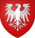 Arms of La Haye-du-Puits |
The arms of La Haye-du-Puits are blazoned : Gules, an eagle (displayed) argent.
|
See also
References
- ↑ Téléchargement du fichier d'ensemble des populations légales en 2019, INSEE
- ↑ Arrêté préfectoral 20 November 2015 (in French) It is roughly 54 miles from Caen (as the crow flies) and 179 miles from Paris (crow flies)
Wikimedia Commons has media related to La Haye-du-Puits.
This article is issued from Wikipedia. The text is licensed under Creative Commons - Attribution - Sharealike. Additional terms may apply for the media files.