La Haye | |
|---|---|
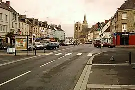 The centre of La Haye-du-Puits at Général-de-Gaulle Place | |
Location of La Haye | |
 La Haye  La Haye | |
| Coordinates: 49°17′28″N 1°32′42″W / 49.291°N 1.545°W | |
| Country | France |
| Region | Normandy |
| Department | Manche |
| Arrondissement | Coutances |
| Canton | Créances |
| Government | |
| • Mayor (2020–2026) | Alain Leclere[1] |
| Area 1 | 63.81 km2 (24.64 sq mi) |
| Population | 3,971 |
| • Density | 62/km2 (160/sq mi) |
| Time zone | UTC+01:00 (CET) |
| • Summer (DST) | UTC+02:00 (CEST) |
| INSEE/Postal code | 50236 /50250 |
| 1 French Land Register data, which excludes lakes, ponds, glaciers > 1 km2 (0.386 sq mi or 247 acres) and river estuaries. | |
La Haye (French pronunciation: [la ɛ] ⓘ) is a commune in the department of Manche, northwestern France. The municipality was established on 1 January 2016 by merger of the former communes of La Haye-du-Puits (the seat), Baudreville, Bolleville, Glatigny, Mobecq, Montgardon, Saint-Rémy-des-Landes, Saint-Symphorien-le-Valois and Surville.[3]
Population
| Year | Pop. | ±% p.a. |
|---|---|---|
| 1968 | 3,869 | — |
| 1975 | 3,864 | −0.02% |
| 1982 | 3,890 | +0.10% |
| 1990 | 4,031 | +0.45% |
| 1999 | 4,166 | +0.37% |
| 2007 | 4,211 | +0.13% |
| 2012 | 4,112 | −0.47% |
| 2017 | 4,006 | −0.52% |
| Source: INSEE[4] | ||
See also
References
Wikimedia Commons has media related to La Haye (Manche).
- ↑ "Répertoire national des élus: les maires" (in French). data.gouv.fr, Plateforme ouverte des données publiques françaises. 13 September 2022.
- ↑ "Populations légales 2021". The National Institute of Statistics and Economic Studies. 28 December 2023.
- ↑ Arrêté préfectoral 20 November 2015 (in French)
- ↑ Population en historique depuis 1968, INSEE
This article is issued from Wikipedia. The text is licensed under Creative Commons - Attribution - Sharealike. Additional terms may apply for the media files.