53°59′31″N 2°55′41″W / 53.992°N 2.928°W
| Lancaster and Wyre | |
|---|---|
| Former County constituency for the House of Commons | |
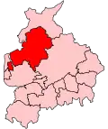
 Boundary of Lancaster and Wyre in Lancashire for the 2005 general election | |
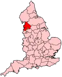
 Location of Lancashire within England | |
| County | Lancashire |
| 1997–2010 | |
| Seats | One |
| Created from | Lancaster and Wyre |
| Replaced by | Lancaster and Fleetwood, Wyre and Preston North |
Lancaster and Wyre was a parliamentary constituency represented in the House of Commons of the Parliament of the United Kingdom. From 1997 to 2010, it elected one Member of Parliament (MP) by the first past the post system of election, but has now been replaced by Lancaster and Fleetwood.
Further to the completion of the 2023 Periodic Review of Westminster constituencies, the seat will be re-established for the next general election.[1] Its boundaries will be similar to those of the 1997-2010 version and will largely replace Lancaster and Fleetwood.
History
This seat was created for the 1997 general election and was abolished at the 2010 general election. It was a marginal seat between the Labour and Conservative parties throughout its existence, and was the only seat gained by the Conservatives in the North West in the 2005 general election.
Boundaries
The City of Lancaster wards of Bulk, Castle, Caton, Ellel, John O'Gaunt, Scotforth East, and Scotforth West, and the Borough of Wyre wards of Breck, Brock, Calder, Carleton, Catterall, Duchy, Garstang, Hambleton, Hardhorn, High Cross, Norcross, Pilling, Preesall, Staina, Tithebarn, and Wyresdale.
The Boundary Commission for England's proposals for parliamentary constituencies in Lancashire were completed in 2006. They proposed to split this seat into two.[2] As a result, Lancaster was attached to another part of Wyre borough, over the River Wyre to the fishing port of Fleetwood. The new seat of Lancaster and Fleetwood represents the first time the two places have been linked for parliamentary reasons for many years.
The other seat is the new Wyre and Preston North.[2] This seat has never been created before, and the bringing together of Garstang, Thornton, Poulton-le-Fylde and the Fulwood and northern rural areas of Preston is unprecedented.
Proposed
Further to the 2023 Periodic Review of Westminster constituencies, enacted by the Parliamentary Constituencies Order 2023, from the next general election, due by January 2025, the re-established constituency will be composed of the following wards (as they existed on 1 December 2020):
- The City of Lancaster wards of: Bulk; Castle; Ellel; John O’Gaunt; Marsh; Scotforth East; Scotforth West; Skerton East; Skerton West; University & Scotforth Rural.
- The District of Wyre wards of: Brock with Catterall; Calder; Garstang; Great Eccleston; Hambleton & Stalmine; Pilling; Preesall; Wyresdale.[3]
The constituency will comprise the majority of, and replace, the constituency of Lancaster and Fleetwood - excluding the town of Fleetwood. It will be expanded to include the community of Skerton, transferred from Morecambe and Lunesdale, together with Garstang and surrounding rural areas, currently part of Wyre and Preston North (to be abolished).
Members of Parliament
| Election | Member[4] | Party | |
|---|---|---|---|
| 1997 | Hilton Dawson | Labour | |
| 2005 | Ben Wallace | Conservative | |
| 2010 | constituency abolished: see Lancaster and Fleetwood and Wyre and Preston North | ||
There were only two Members of Parliament for this seat. Ben Wallace was selected to represent the Conservatives at the 2010 election in the successor seat of Wyre and Preston North.
Elections
Elections in to 2000s
| Party | Candidate | Votes | % | ±% | |
|---|---|---|---|---|---|
| Conservative | Ben Wallace | 22,266 | 42.8 | +0.6 | |
| Labour | Anne Sacks | 18,095 | 34.8 | -8.3 | |
| Liberal Democrats | Stuart Langhorn | 8,453 | 16.2 | +5.9 | |
| Green | Jon Barry | 2,278 | 4.4 | +1.4 | |
| UKIP | John Mander | 969 | 1.9 | +0.5 | |
| Majority | 4,171 | 8.0 | N/A | ||
| Turnout | 52,061 | 64.5 | -1.4 | ||
| Conservative gain from Labour | Swing | ||||
| Party | Candidate | Votes | % | ±% | |
|---|---|---|---|---|---|
| Labour | Hilton Dawson | 22,556 | 43.1 | +0.3 | |
| Conservative | Steve Barclay | 22,075 | 42.2 | +1.6 | |
| Liberal Democrats | Elizabeth Scott | 5,383 | 10.3 | -1.2 | |
| Green | John Whitelegg | 1,595 | 3.0 | +1.7 | |
| UKIP | John Whittaker | 741 | 1.4 | +0.2 | |
| Majority | 481 | 0.9 | -1.3 | ||
| Turnout | 52,350 | 65.9 | -8.9 | ||
| Labour hold | Swing | ||||
Elections in the 1990s
| Party | Candidate | Votes | % | ±% | |
|---|---|---|---|---|---|
| Labour | Hilton Dawson | 25,173 | 42.8 | +9.7 | |
| Conservative | Keith Mans | 23,878 | 40.6 | -11.6 | |
| Liberal Democrats | John C. Humberstone | 6,802 | 11.5 | -2.4 | |
| Referendum | Vivien Ivell | 1,516 | 2.6 | New | |
| Green | Jon Barry | 795 | 1.3 | New | |
| UKIP | John Whittaker | 698 | 1.2 | New | |
| Majority | 1,295 | 2.2 | |||
| Turnout | 58,862 | 74.8 | |||
| Labour win (new seat) | |||||
See also
Notes and references
- ↑ "The 2023 Review of Parliamentary Constituency Boundaries in England – Volume one: Report – North West | Boundary Commission for England". boundarycommissionforengland.independent.gov.uk. Retrieved 30 July 2023.
- 1 2 "Boundary Commission For England: Fifth Periodical Report" (PDF). London: The Stationery Office.
- ↑ "The Parliamentary Constituencies Order 2023". Schedule 1 Part 5 North West region.
- ↑ Leigh Rayment's Historical List of MPs – Constituencies beginning with "L" (part 1)
- ↑ "Election Data 2005". Electoral Calculus. Archived from the original on 15 October 2011. Retrieved 18 October 2015.
- ↑ "Election Data 2001". Electoral Calculus. Archived from the original on 15 October 2011. Retrieved 18 October 2015.
- ↑ "Election Data 1997". Electoral Calculus. Archived from the original on 15 October 2011. Retrieved 18 October 2015.