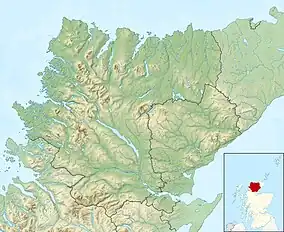
| Loch Leitir Easaidh | |
|---|---|
 Loch Leitir Easaidh at dusk | |
 Loch Leitir Easaidh | |
| Location | NC16802657 |
| Coordinates | 58°11′23″N 5°07′05″W / 58.18980026°N 5.11801710°W |
| Type | freshwater loch |
| Primary inflows | unnamed burns flow from Loch na h-Innse Fraoich in the southeast and Loch Bad a' Chigean from the northeast. |
| Primary outflows | unnamed burn flows from Loch Leitir Easaidh at the eastern end into Loch Assynt |
| Max. length | 0.804672 km (0.500000 mi)[1] |
| Max. width | 0.643738 km (0.400000 mi)[1] |
| Surface area | 19 ha (47 acres)[2] |
| Average depth | 20.00 ft (6.10 m)[1] |
| Max. depth | 69.88 ft (21.30 m)[1] |
| Water volume | 423,213,862 cu ft (11,984,082.0 m3)[1] |
| Shore length1 | 3 km (1.9 mi) [2] |
| Surface elevation | 67 m (220 ft)[2] |
| Max. temperature | 53.5 °F (11.9 °C) |
| Min. temperature | 42.0 °F (5.6 °C) |
| 1 Shore length is not a well-defined measure. | |
Loch Leitir Easaidh is a small shallow irregular shaped freshwater lochan that flows directly into the northwestern end of Loch Assynt in Assynt, Sutherland, Scotland.[2][1] The loch is located in an area along with neighbouring Coigach, as the Assynt-Coigach National Scenic Area,[3] one of 40 such areas in Scotland.[4]
Geography
Loch Leitir Easaidh sits of the eastern end of a low-lying plateau, that is heavily populated with a number of other lochs to the east, that drain into Loch Inver basin. At the northern end of the plateau is a trending fault that travels in a northwest–southeast direction, traveling through Loch Assynt, Loch Leitir Easaidh along Gleannan Salach, through Loch na Loinne to Loch Poll and the coast.[5]
To the north and northeast sit the three peaks of the Quinag,(Scottish Gaelic: A’ Chuineag) that sit in a Y-shaped crest. The three Corbett summits are Quinag - Sail Gorm at 776m, Quinag - Sail Gharbh at 808m and Quinag - Spidean Coinich at 764 m.[6]
Walking and fishing
The loch is popular with both fly-fisherman and walkers and has an all-access, all-abilities walk that has been developed by the Culag Community Woodland Trust.[7][8] Two toilet blocks are provided at the loch.
The predominant species of fish found in the region were recently catalogued during a survey in November 2019.[9] The predominant species of fish are trout and Salvelinus (char).
References
- 1 2 3 4 5 6 John, Murray; Lawrence, Pullar (1910). Bathymetrical Survey of the Fresh-Water Lochs of Scotland, 1897-1909 Lochs of the Tay Basin Volume II - Loch Leitir Easaidh. National Library of Scotland: National Challenger Officer. p. 151. Retrieved 13 April 2021.
 This article incorporates text from this source, which is in the public domain.
 - 1 2 3 4 "Loch Leitir Easaidh". Centre for Ecology and Hydrology. UK Centre for Ecology & Hydrology. Retrieved 13 April 2021.
- ↑ "Assynt-Coigach National Scenic Area". NatureScot. Retrieved 2 October 2020.
- ↑ "National Scenic Areas". NatureScot. Retrieved 2 October 2020.
- ↑ Savindra Singh; Ram Chandra Tiwari (1989). Geomorphology and Environment. Allahabad Geographical Society, Department of Geography, University of Allahabad. Retrieved 15 April 2021.
- ↑ Kirstie Shirra (21 March 2011). Scotland's Best Small Mountains: 40 of the best small mountains in Scotland under 3000ft. Cicerone Press Limited. pp. 30–31. ISBN 978-1-84965-345-9. Retrieved 15 April 2021.
- ↑ "Walk: Privy to a stunning sunset at Leitir Easaidh". Scotland Off the Beaten Track. 12 July 2017. Retrieved 16 April 2021.
- ↑ "Leitir Easaidh All-Abilities path, Little Assynt". Walk Highlands. Retrieved 16 April 2021.
- ↑ Marshall, Shona (November 2019). "Coigach & Assynt Living Landscape Partnership (CALLP) Scheme P03 Freshwater Lochan Survey: An inventory of the fish populations of 20 of the Coigach & Assynt lochs" (PDF). Coigach & Assynt Living Landscape. West Sutherland Fisheries Trust. Retrieved 16 April 2021.