Mūkupurvs | |
|---|---|
Neighbourhood of Riga | |
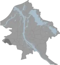
 Location of Mūkupurvs in Riga | |
| Country | Latvia |
| City | Riga |
| District | Zemgale Suburb |
| Area | |
| • Total | 4.515 km2 (1.743 sq mi) |
| Population (2021) | |
| • Total | 242 |
| • Density | 54/km2 (140/sq mi) |
| Website | apkaimes.lv |
Mūkupurvs is a neighborhood of the city of Riga, the capital city of Latvia and in Pārdaugava, a suburb of Zemgale. Mūkupurva neighborhood is located in the R part of Riga. It borders Beberbekai, Zolitūde and Pleskodāle neighborhoods, as well as Mārupe parish of Mārupe county, which is adjacent to the D part of Mūkupurva neighborhood. The boundaries of the Mūkupurva neighborhood are a line parallel to Beberbeķu line 5, Krotes iela, a line along the residential massif, the city boundary (Babītes iela, Kalnciema iela) and Kārļa Ulmanias gatve.
The total area of Mūkupurva neighborhood has a population of 242,[1] and its area 4,515 km2, which is only slightly less than the average area indicator of Riga neighborhoods. Currently, this neighborhood is a very underdeveloped area of Riga, but judging by its location and configuration, it can be created and function as a unified neighborhood in the future. Along the perimeter, the length of the boundary of Mūkupurva neighborhood is 10,293 meters. The D part of Mūkupurva neighborhood, which is also the border of the city of Riga, is adjacent to the territory of the Riga International Airport.
References
- ↑ "Riga City (Latvia): Quarters - Population Statistics, Charts and Map". www.citypopulation.de. Retrieved 2022-10-01.
56°56′18″N 23°58′51″E / 56.9383°N 23.9808°E