Maku County
Persian: شهرستان ماکو | |
|---|---|
County | |
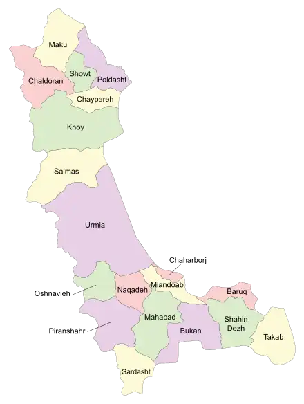
 Location of Maku County in West Azerbaijan province (top, yellow) | |
 Location of West Azerbaijan province in Iran | |
| Coordinates: 39°26′N 44°39′E / 39.433°N 44.650°E[1] | |
| Country | |
| Province | West Azerbaijan |
| Capital | Maku |
| Districts | Central, Bazargan |
| Population (2016)[2] | |
| • Total | 94,751 |
| Time zone | UTC+3:30 (IRST) |
Maku County (Persian: شهرستان ماکو) is in West Azerbaijan province, Iran. Its capital is the city of Maku.[3]
At the 2006 census, the county's population was 174,578 in 39,765 households.[4] The following census in 2011 counted 88,863 people in 22,874 households,[5] by which time Poldasht and Showt districts had been separated from the county to form Poldasht County and Showt County, respectively. At the same time, Chaybasar-e Shomali Rural District and the city of Bazargan had been separated from the Central District in the establishment of Bazargan District.[6] At the 2016 census, Maku County's population was 94,751 in 27,009 households.[2]
Administrative divisions
The population history and structural changes of Maku County's administrative divisions over three consecutive censuses are shown in the following table. The latest census shows two districts, five rural districts, and two cities.[2]
| Administrative Divisions | 2006[4] | 2011[5] | 2016[2] |
|---|---|---|---|
| Central District | 84,516 | 70,133 | 75,075 |
| Chaybasar-e Jonubi RD | 10,148 | 8,684 | 8,520 |
| Chaybasar-e Shomali RD | 11,295 | ||
| Qaleh Darrehsi RD | 12,161 | 11,743 | 13,962 |
| Qarah Su RD | 6,955 | 6,012 | |
| Bazargan (city) | 9,047 | ||
| Maku (city) | 41,865 | 42,751 | 46,581 |
| Bazargan District | 18,730 | 19,676 | |
| Chaybasar-e Shomali RD | 4,908 | 4,961 | |
| Sari Su RD | 4,271 | 4,736 | |
| Bazargan (city) | 9,551 | 9,979 | |
| Poldasht District1 | 38,586 | ||
| Chaybasar-e Sharqi RD | 6,132 | ||
| Gejlarat-e Gharbi RD | 6,138 | ||
| Gejlarat-e Sharqi RD | 6,578 | ||
| Zangebar RD | 11,154 | ||
| Poldasht (city) | 8,584 | ||
| Showt District2 | 51,476 | ||
| Qarah Quyun-e Jonubi RD | 13,931 | ||
| Qarah Quyun-e Shomali RD | 6,170 | ||
| Yowla Galdi RD | 11,616 | ||
| Showt (city) | 19,759 | ||
| Total | 174,578 | 88,863 | 94,751 |
| RD: Rural District 1Became a part of Poldasht County[6] 2Became a part of Showt County[6] | |||
References
- ↑ OpenStreetMap contributors (6 April 2023). "Maku County" (Map). OpenStreetMap. Retrieved 6 April 2023.
- 1 2 3 4 "Census of the Islamic Republic of Iran, 1395 (2016)". AMAR (in Persian). The Statistical Center of Iran. p. 04. Archived from the original (Excel) on 30 August 2022. Retrieved 19 December 2022.
- ↑ Habibi, Hassan (7 July 1369). "Approval of the organization and chain of citizenship of the elements and units of the country divisions of West Azerbaijan province, centered in the city of Urmia". Lamtakam (in Persian). Ministry of Interior, Council of Ministers. Archived from the original on 20 December 2023. Retrieved 20 December 2023.
- 1 2 "Census of the Islamic Republic of Iran, 1385 (2006)". AMAR (in Persian). The Statistical Center of Iran. p. 04. Archived from the original (Excel) on 20 September 2011. Retrieved 25 September 2022.
- 1 2 "Census of the Islamic Republic of Iran, 1390 (2011)". Syracuse University (in Persian). The Statistical Center of Iran. p. 04. Archived from the original (Excel) on 20 January 2023. Retrieved 19 December 2022.
- 1 2 3 Davodi, Parviz (18 September 1386). "Approval letter regarding reforms of country divisions in West Azerbaijan province". Islamic Parliament Research Center (in Persian). Ministry of Interior, Political-Defense Commmission. Archived from the original on 13 April 2014. Retrieved 21 November 2023.
