 | |
|---|---|
| Jalan Pengkalan Kubur | |
| Route information | |
| Length | 21.87 km (13.59 mi) |
| Major junctions | |
| Northwest end | Pengkalan Kubur |
| Southeast end | Pasir Pekan |
| Location | |
| Country | Malaysia |
| Primary destinations | Tak Bai (Thailand) Wakaf Bharu |
| Highway system | |
Federal Route 134, or Jalan Pengkalan Kubur, is a federal road in Kelantan, Malaysia.[1] The Kilometre Zero of the Federal Route 134 starts at Pengkalan Kubur
Features
At most sections, the Federal Route 134 was built under the JKR R5 road standard, allowing maximum speed limit of up to 90 km/h.
Kilometre zero
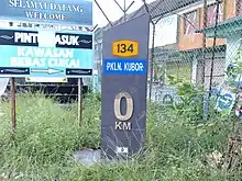
KM 0 Pengkalan Kubor at the Federal Route 134
List of junctions and towns
| Km | Exit | Junctions | To | Remarks |
|---|---|---|---|---|
0 | Pengkalan Kubur Pengkalan Kubur Ferry Terminal and Checkpoint | Pengkalan Kubur Ferry Terminal and Checkpoint (Ferry Terminal = Ferry to Tak Bai (Thailand)) | ||
| Pengkalan Kubur Pengkalan Kubor Duty Free Zone | Pengkalan Kubor Duty Free Zone Southwest Jalan Mertua | Junctions | ||
| Pengkalan Kubur | Northeast Jalan Masjid Town Centre Masjid Pengkalan Kubor | T-junctions | ||
| Pengkalan Kubur | Southwest | T-junctions | ||
| Pengkalan Kubur | Northeast Town Centre Pantai Tujuh Tumpat | T-junctions | ||
| Pengkalan Kubor Health Clinic | ||||
| Kampung Kok Serai | East Kampung Tebok | T-junctions | ||
| Kampung Belukar | ||||
| Kampung Kok Semeru | ||||
| Kampung Pauh Sebanjan | ||||
| Kampung Baruh Kok Pauh | ||||
| Kampung Jubakar | ||||
| Kampung Bunohan | ||||
| Kampung Telaga | ||||
| Kampung Kubang Panjang | ||||
| Kampung Cherang | ||||
| Kampung Telok | ||||
| Kampung Kubang Gajah | ||||
| Kampung Bendang | Northwest Southwest 4056 Wat Photivihan | T-junctions | ||
| Kampung Chondong Bata | South Kampung Kubang Batang | T-junctions | ||
| Kmapung Belukar | ||||
| Kampung Lati | ||||
| Wakaf Bharu | Wakaf Bharu railway station | |||
| Wakaf Bharu | North Tumpat | Roundabout | ||
| Railway crossing | ||||
| Pasir Pekan | North Masjid Al-Ismaili Pasir Pekan East Southwest 4056 | Junctions |
References
- ↑ Statistik Jalan (Edisi 2013). Kuala Lumpur: Malaysian Public Works Department. 2013. pp. 16–64. ISSN 1985-9619.
This article is issued from Wikipedia. The text is licensed under Creative Commons - Attribution - Sharealike. Additional terms may apply for the media files.