Marshall County | |
|---|---|
| Marshall County, Adventure Bay | |
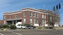
 Marshall County Courthouse in Benton, Kentucky. | |
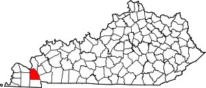
 Location within the U.S. state of Kentucky | |
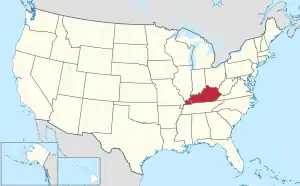
 Kentucky's location within the U.S. | |
| Coordinates: 36°53′N 88°20′W / 36.88°N 88.34°W | |
| Country | |
| State | |
| Founded | 1842 |
| Named for | John Marshall |
| Seat | Benton |
| Largest city | Benton |
| Area | |
| • Total | 340 sq mi (900 km2) |
| • Land | 301 sq mi (780 km2) |
| • Water | 39 sq mi (100 km2) 11% |
| Population (2020) | |
| • Total | 31,659 |
| • Estimate (2022) | 31,777 |
| • Density | 93/sq mi (36/km2) |
| Time zone | UTC−6 (Central) |
| • Summer (DST) | UTC−5 (CDT) |
| Congressional district | 1st |
| Website | www |
Marshall County is a county located in far western portion of the U.S. state of Kentucky. As of the 2020 census, the population was 31,659.[1] Its county seat is Benton.[2]
It is the only Purchase Area county that does not border another state; a narrow strip of land in neighboring Livingston County separates Marshall County from the Ohio River and the Illinois border. Until July 28, 2015, it was a dry county. On that date residents approved alcohol sales for off-premises consumption, making it a "wet" county.
History
Following population increase in the area, Marshall County was created by the Kentucky legislature in 1842 from the northern half of Calloway County.[3] The first European-American settlers had arrived in about 1818, shortly after the area was bought from the Chickasaw Indians as part of the Jackson Purchase by Gen. Andrew Jackson and Kentucky Gov. Isaac Shelby. The Chickasaw were forced under Indian Removal to move to what became known as Indian Territory, new and much less fertile lands west of the Mississippi River.
Marshall County was named in honor of Chief Justice John Marshall of the United States Supreme Court, who had died in 1835.[4]
Like most of the Jackson Purchase, and reflecting its geographic and family connections to the South, during the American Civil War, Marshall County was strongly pro-Confederate, although the state was neutral. Many local men served in the famous Kentucky Orphan Brigade. On March 23, 1864, detachments of Gen. Nathan Bedford Forrest's Confederate cavalry clashed with Union cavalry near Benton, when each side was scouring the countryside for needed cavalry remounts. A state historical marker stands at the site.[5]
From its settlement until the 1930s, Marshall County was developed primarily for agriculture. In the 1940s, however, the Tennessee Valley Authority created Kentucky Lake as part of its flood control and rural electrification projects initiated by President Franklin D. Roosevelt. The lake established tourism as part of the county's economy, and lakeshore resorts were developed to exploit sports fishing.
Kentucky Dam's cheap and plentiful electricity also attracted chemical and manufacturing plants, mainly in the Calvert City area.
The lake's impoundment resulted in flooding two historic Marshall County towns: Birmingham, six miles north of Fairdealing, and Gilbertsville, at the dam's site, both of which were evacuated. Gilbertsville was relocated west of its original location, but Birmingham residents had to find new homes elsewhere. Gilbertsville was an incorporated town until the 1970s, when its charter was dissolved by public vote. Kentucky Lake (created on the Tennessee River) and Lake Barkley (created on the Cumberland River) were connected by a canal. Together they make up one of the largest man-made bodies of water in the world.
Geography
According to the United States Census Bureau, the county has a total area of 340 square miles (880 km2), of which 301 square miles (780 km2) is land and 39 square miles (100 km2) (11%) is water.[6] The county's northeastern border is formed by the Tennessee River and Kentucky Lake.
Adjacent counties
- Livingston County (north)
- Lyon County (east)
- Trigg County (east)
- Calloway County (south)
- Graves County (west)
- McCracken County (west)
National protected area
Demographics
| Census | Pop. | Note | %± |
|---|---|---|---|
| 1850 | 5,269 | — | |
| 1860 | 6,982 | 32.5% | |
| 1870 | 9,455 | 35.4% | |
| 1880 | 9,647 | 2.0% | |
| 1890 | 11,287 | 17.0% | |
| 1900 | 13,692 | 21.3% | |
| 1910 | 15,771 | 15.2% | |
| 1920 | 15,215 | −3.5% | |
| 1930 | 12,889 | −15.3% | |
| 1940 | 16,602 | 28.8% | |
| 1950 | 13,387 | −19.4% | |
| 1960 | 16,736 | 25.0% | |
| 1970 | 20,381 | 21.8% | |
| 1980 | 25,637 | 25.8% | |
| 1990 | 27,205 | 6.1% | |
| 2000 | 30,125 | 10.7% | |
| 2010 | 31,448 | 4.4% | |
| 2020 | 31,659 | 0.7% | |
| 2022 (est.) | 31,777 | [7] | 0.4% |
| U.S. Decennial Census[8] 1790–1960[9] 1900–1990[10] 1990–2000[11] 2010–2020[1] | |||
As of the census[12] of 2000, there were 30,125 people, 12,412 households, and 8,998 families residing in the county. The population density was 99 per square mile (38/km2). There were 14,730 housing units at an average density of 48 per square mile (19/km2). The racial makeup of the county was 98.57% White, 0.2% Black or African American, 0.17% Native American, 0.15% Asian, 0.01% Pacific Islander, 0.22% from other races, and 0.76% from two or more races. 0.76% of the population were Hispanics or Latinos of any race.
There were 12,412 households, out of which 29.20% had children under the age of 18 living with them, 61.40% were married couples living together, 7.90% had a female householder with no husband present, and 27.50% were non-families. 25.00% of all households were made up of individuals, and 11.90% had someone living alone who was 65 years of age or older. The average household size was 2.38 and the average family size was 2.83.
The age distribution was 21.80% under the age of 18, 7.50% from 18 to 24, 27.00% from 25 to 44, 26.20% from 45 to 64, and 17.50% who were 65 years of age or older. The median age was 41 years. For every 100 females there were 96.10 males. For every 100 females age 18 and over, there were 93.50 males.
The median income for a household in the county was $35,573, and the median income for a family was $43,670. Males had a median income of $36,673 versus $21,941 for females. The per capita income for the county was $18,069. About 6.60% of families and 9.50% of the population were below the poverty line, including 11.60% of those under age 18 and 10.90% of those age 65 or over.
Communities
Cities
- Benton (county seat)
- Calvert City
- Hardin
Census-designated place
Other unincorporated communities
- Aurora
- Big Bear Area
- Brewers
- Briensburg
- Draffenville
- Fairdealing
- Harvey
- Moors Camp Area
- Oak Level
- Olive
- Palma
- Possum Trot
- Sharpe
- Tatumsville
Ghost town
Annual events
On the first Monday of April, Benton holds its Tater Day. Originating in 1842 as a day for farmers to gather at the county seat to trade their agricultural goods, today Tater Day is a celebration that includes a festival and parade. Tater Day derives its name from the main item traded—sweet potatoes for seed, i.e., for bedding in prepared "seedbeds" to produce slips for growers to transplant to gardens or fields.
On the fourth Sunday of each May, The Big Singing, an all-day sing-along program of Southern Harmony shape note gospel music is held at the county courthouse. The Big Singing, begun in 1884, has a special claim to fame: in 1933 George Pullen Jackson drew attention to the fact that this is the only regular event that sings from William Walker's Southern Harmony;[13] this remains a living tradition to the present day.[14]
Attractions and other information
Marshall County is the home of Calvert Drive In Theater, the only one in the Purchase area and one of three within an 85-mile radius in far western Kentucky.[15][16]
Marshall County is also home to the Silver Trail Distillery, where a family legend was revitalized to produce LBL Moonshine, named for the illegal liquor distilled in the "Land Between the Rivers," now the Land Between the Lakes. The distillery and museum are in Hardin and Aurora. The original moonshiner, Cilous, was known to have a sipping ritual when it came time to drink his 'shine: "Take a small sip, don't shoot it, and keep your lips closed. With your lips still closed, swish gently then let it ease down. When it is down to the navel level, open your lips slowly while exhaling. There will be a fresh corn taste on both sides of the mouth and no bitter aftertaste."[17]
Before Interstate 24 rerouted much of US 68 traffic northward, generations spent summer days and nights at The Forgotten Past Amusement Park with its gift shop, go carts, bumper cars, mini golf, museum, and arcade.[18] For many years it hosted an Antique (steel wheeled) Tractor Show.
Marshall County is home to one of the largest and most complete parks in the Purchase area. It has lighted baseball fields, two basketball courts, four soccer fields, two tennis courts, a large fishing pond, large playground, spray park, and multiple picnic pavilions as well as a conference center. It is built upon land donated from a private family in memory of their son who was killed in action in the Vietnam War. In September 2000 the park was dedicated as the Marshall County Park. Later that year the local judge executive Mike Miller appointed the new park board. Upon the Grand Opening the park board had named it Mike Miller Park. Several people protested and the park board renamed it Mike Miller County Park. The original statute dedication as Marshall County Park remains at the entrance of the park. The original park didn't have any mention of veterans in its mission; in response the fiscal court commissioned a large veteran's park adjacent to the main conference center.[19]
Marshall County is home to the FLW Bass Tournament organization, named for founder of Ranger Boats, Forrest L. Wood. Wood is the purveyor of America's largest and most prestigious fishing tournaments, including the FLW Tour, FLW Series, Bass Fishing League, College Fishing and High School Fishing.[20]
Politics
Until the 2018 election, Marshall County's local politics had been a stronghold of the Democratic party. In 2015, all elected county officials were Democrats, except for one: Republican Kevin Neal defeated Melonie Watkins Chambers to finish the unexpired term of longtime County Judge-Executive Mike Miller, who died in office the previous December. In the 2018 election, things changed considerably in the county with the re-election of Kevin Neal as the County Judge-Executive along with several fellow Republicans: Danny Carroll as Kentucky Senator of the 1st District; Chris Freeland as the Kentucky House of Representative of the 6th District; Kevin Spraggs as 2nd District County Commissioner; Monti Collins as 3rd District County Commissioner; Eddie McGuire as County Sheriff' and Michael Gordon as County Coroner. Therefore, as of 2018, the local offices of Marshall County have 5 Republicans, 5 Democrats and 1 Independent.
County voters have preferred the Republican candidate for US president in 1972 and in all elections since 2000.
| Year | Republican | Democratic | Third party | |||
|---|---|---|---|---|---|---|
| No. | % | No. | % | No. | % | |
| 2020 | 13,297 | 75.54% | 4,071 | 23.13% | 235 | 1.33% |
| 2016 | 12,322 | 73.79% | 3,672 | 21.99% | 704 | 4.22% |
| 2012 | 10,402 | 66.17% | 5,022 | 31.95% | 295 | 1.88% |
| 2008 | 9,512 | 61.42% | 5,683 | 36.70% | 292 | 1.89% |
| 2004 | 9,049 | 58.30% | 6,383 | 41.12% | 89 | 0.57% |
| 2000 | 7,294 | 53.00% | 6,203 | 45.08% | 264 | 1.92% |
| 1996 | 4,579 | 37.91% | 6,054 | 50.12% | 1,445 | 11.96% |
| 1992 | 4,368 | 34.26% | 6,576 | 51.58% | 1,805 | 14.16% |
| 1988 | 5,256 | 47.05% | 5,888 | 52.71% | 27 | 0.24% |
| 1984 | 5,152 | 47.19% | 5,725 | 52.44% | 40 | 0.37% |
| 1980 | 4,403 | 40.85% | 6,231 | 57.81% | 145 | 1.35% |
| 1976 | 2,578 | 26.82% | 6,906 | 71.83% | 130 | 1.35% |
| 1972 | 4,290 | 59.16% | 2,806 | 38.69% | 156 | 2.15% |
| 1968 | 2,432 | 30.70% | 3,301 | 41.67% | 2,188 | 27.62% |
| 1964 | 1,679 | 21.90% | 5,968 | 77.83% | 21 | 0.27% |
| 1960 | 3,388 | 49.30% | 3,484 | 50.70% | 0 | 0.00% |
| 1956 | 2,015 | 31.57% | 4,358 | 68.29% | 9 | 0.14% |
| 1952 | 1,474 | 29.87% | 3,445 | 69.82% | 15 | 0.30% |
| 1948 | 711 | 19.25% | 2,942 | 79.66% | 40 | 1.08% |
| 1944 | 1,316 | 30.79% | 2,947 | 68.95% | 11 | 0.26% |
| 1940 | 1,100 | 23.60% | 3,549 | 76.13% | 13 | 0.28% |
| 1936 | 1,141 | 24.68% | 3,472 | 75.09% | 11 | 0.24% |
| 1932 | 863 | 16.83% | 4,246 | 82.78% | 20 | 0.39% |
| 1928 | 1,879 | 47.87% | 2,036 | 51.87% | 10 | 0.25% |
| 1924 | 1,192 | 29.73% | 2,752 | 68.63% | 66 | 1.65% |
| 1920 | 1,883 | 34.29% | 3,569 | 64.99% | 40 | 0.73% |
| 1916 | 1,201 | 34.02% | 2,263 | 64.11% | 66 | 1.87% |
| 1912 | 634 | 22.75% | 1,675 | 60.10% | 478 | 17.15% |
Notable people
- Joe Creason – Longtime reporter and columnist for the Louisville Courier Journal[22]
- Robert H. Grubbs - Winner of the 2005 Nobel Prize in Chemistry
- Terrina Chrishell Stause - American actress; known for her role on the Netflix reality show Selling Sunset, along with previous television roles as Amanda Dillon on All My Children and Jordan Ridgeway on Days of Our Lives.
See also
References
Books
- Big Singing Day in Benton, Kentucky: A Study of the History, Ethnic Identity and Musical Style of Southern Harmony Singers, by Deborah Carlton Loftis, Ph.D. dissertation, University of Kentucky, 1987. Review
References
- 1 2 "State & County QuickFacts". United States Census Bureau. Retrieved July 13, 2022.
- ↑ "Find a County". National Association of Counties. Retrieved June 7, 2011.
- ↑ Collins, Lewis (1877). History of Kentucky. p. 542. ISBN 9780722249208.
- ↑ The Register of the Kentucky State Historical Society, Volume 1. Kentucky State Historical Society. 1903. p. 36.
- ↑ "JPFOB". JPFOB. Retrieved January 23, 2018.
- ↑ "2010 Census Gazetteer Files". United States Census Bureau. August 22, 2012. Archived from the original on August 12, 2014. Retrieved August 17, 2014.
- ↑ "Annual Estimates of the Resident Population for Counties: April 1, 2020 to July 1, 2022". United States Census Bureau. Retrieved April 2, 2023.
- ↑ "U.S. Decennial Census". United States Census Bureau. Retrieved August 17, 2014.
- ↑ "Historical Census Browser". University of Virginia Library. Retrieved August 17, 2014.
- ↑ "Population of Counties by Decennial Census: 1900 to 1990". United States Census Bureau. Retrieved August 17, 2014.
- ↑ "Census 2000 PHC-T-4. Ranking Tables for Counties: 1990 and 2000" (PDF). United States Census Bureau. Archived (PDF) from the original on March 27, 2010. Retrieved August 17, 2014.
- ↑ "U.S. Census website". United States Census Bureau. Retrieved January 31, 2008.
- ↑ "As early as 1933 G. P. Jackson noted that Benton held the only regular Southern Harmony singing in existence." Loftis, Deborah C. (1990). "Southern Harmony Singing: A Tradition of ShapeNote Practice". Performance Practice Review. 3 (2): 165–169. doi:10.5642/perfpr.199003.02.5. Retrieved January 14, 2020.
- ↑ A widely-used directory of annual Shape Note singings lists three other singings that use Southern Harmony together with other tunebooks, but the Benton Big Singing is the only singing that uses the Southern Harmony exclusively. "Annual Sacred Harp Singings 2020 Directory". Based on Sacred Harp Singings 2019 and 2020 (Minutes book of Sacred Harp Musical Heritage Association). Retrieved February 15, 2020.
- ↑ "Drive-in Movie Theaters of Kentucky and Surrounding States". Driveinmovie.com. Retrieved January 23, 2018.
- ↑ "CDITweb". Calvertdrivein.com. Retrieved January 23, 2018.
- ↑ "Home". LBL Moonshine. Retrieved January 23, 2018.
- ↑ "Custom 404 Page". Kentuckytourism.com. Retrieved January 23, 2018.
- ↑ interview with former County Commissioner Jerome Hicks
- ↑ "About Us". FLW Fishing. July 24, 1996. Retrieved January 23, 2018.
- ↑ David Leip. "Dave Leip's Atlas of U.S. Presidential Elections". Uselectionatlas.org. Retrieved January 23, 2018.
- ↑ Humphreys, George G. (January 18, 2022). The Fall of Kentucky's Rock: Western Kentucky Democratic Politics since the New Deal. University Press of Kentucky. p. 1755. ISBN 978-0-8131-8235-3. Retrieved February 1, 2022.