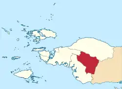
Maybrat Regency
Kabupaten Maybrat | |
|---|---|
 Coat of arms | |
| Motto(s): Anu Beta Tubat (Together We Lift) | |
 Location in Southwest Papua | |
 Maybrat Regency Location in Indonesia | |
| Coordinates: 1°17′33″S 132°22′54″E / 1.292398°S 132.381722°E | |
| Country | Indonesia |
| Province | Southwest Papua |
| Capital | Kumurkek |
| Government | |
| • Regent | Bernad Sagrim |
| • Vice Regent | Paskalis Kocu |
| Area | |
| • Total | 5,461.69 km2 (2,108.77 sq mi) |
| Population (mid 2022 estimate)[1] | |
| • Total | 44,812 |
| • Density | 8.2/km2 (21/sq mi) |
| Time zone | UTC+9 (Indonesia Eastern Time) |
| Area code | (+62) 986 |
Maybrat Regency is a regency of Southwest Papua Province of Indonesia. It has an area of 5,461.69 km2 (2,108.77 sq mi), and had a population of 33,081 at the 2010 Census[2] and 42,991 at the 2020 Census;[3] the official estimate as at mid 2022 was 44,812.[1] The administrative centre is the town of Kumurkek, in Aifat Dstrict. The Maybrat language is spoken in the regency.
Geography
Maybrat Regency is located in the western part of Papua Island. Geographically, Maybrat Regency is located at 131º 421 0” east longitude - 132º 581 12” east and 0º 55' 12” south longitude - 2º 17' 24” south longitude. It is bordered:
- to the north by Fef District, Senopi District and Kebar District;
- to the east by North Moskona District and South Moskona District;
- to the south by Kokoda District and Kais District; and
- to the west by Moswaren District, Wayer District and Sawiat District.[4]
Administrative Districts
At the 2010 Census, the Maybrat Regency comprised eleven districts (distrik), tabulated below with their areas and their populations at the 2010 Census.[2] In 2013 thirteen additional districts were formed by division from the existing districts; these are included below, together with the populations at the 2020 Census of all twenty-four current districts,[3] and their official estimates as at mid 2022.[1] The table also includes the locations of the district administrative centres, the number of administrative villages in each district (totaling 259 rural kampung and 1 urban kelurahan), and its post codes.
| Kode Kemendagri | Name of District (distrik) | Area in km2 | Pop'n 2010 Census | Pop'n 2020 Census | Pop'n mid 2022 Estimate | Admin centre | No. of villages | Post code |
|---|---|---|---|---|---|---|---|---|
| 92.10.05 | Aitinyo Barat (West Aitinyo) | 332.32 | 2,375 | 1,400 | 1,377 | Kambufatem | 9 | 98262 |
| 92.10.17 | Ayamaru Selatan Jaya (South Ayamaru Jaya) | (a) | (a) | 1,560 | 1,554 | Arus | 7 | 98244 |
| 92.10.06 | Aitinyo | 848.36 | 5,150 | 2,820 | 2,909 | Aitinyo | 17 | 98261 |
| 92.10.22 | Aitinyo Tengah (Central Aitinyo) | (b) | (b) | 1,240 | 1,455 | Yaksoro | 14 | 98264 |
| 92.10.04 | Aifat Selatan (South Aifat) | 408.12 | 1,514 | 2,420 | 2,493 | Kisor | 16 | 98272 |
| 92.10.14 | Aifat Timur Selatan (Southeast Aifat) | (c) | (c) | 240 | 343 | Womba | 6 | 98275 |
| 92.10.01 | Aifat | 566.81 | 3,612 | 3,660 | 3,929 | Kumurkek | 23 | 98271 |
| 92.10.07 | Aitinyo Utara (North Aitinyo) | 386.28 | 2,620 | 1,540 | 1,544 | Fategomi | 12 | 98265 |
| 92.10.23 | Aitinyo Raya (Great Aitinyo) | (d) | (d) | 1,320 | 1,385 | Jitmau | 10 | 98265 |
| 92.10.10 | Ayamaru Timur (East Ayamaru) | 126.09 | 1,201 | 1,490 | 1,390 | Kambuaya | 8 | 98246 |
| 92.10.18 | Ayamaru Timur Selatan (Southeast Ayamaru) | (e) | (e) | 1,120 | 1,126 | Kambuskato | 7 | 98247 |
| 92.10.08 | Ayamaru | 538.60 | 5,592 | 2,760 | 2,788 | Mefkajin II | 8 (f) | 98240 |
| 92.10.15 | Ayamaru Selatan (South Ayamaru) | (g) | (g) | 2,030 | 2,073 | Koma-Koma | 10 | 98243 |
| 92.10.16 | Ayamaru Jaya (Great Ayamaru) | (g) | (g) | 2,520 | 2,498 | Segior | 10 | 98242 |
| 92.10.20 | Ayamaru Tengah (Central Ayamaru) | (g) | (g) | 2,430 | 2,632 | Kartapura | 10 | 98245 |
| 92.10.21 | Ayamaru Barat (West Ayamaru) | (g) | (g) | 1,440 | 1,547 | Soroan | 8 | 98241 |
| 92.10.09 | Ayamaru Utara (North Ayamaru) | 442.95 | 3,846 | 2,640 | 2,757 | Yukase | 11 | 98248 |
| 92.10.19 | Ayamaru Utara Timur (Northeast Ayamaru) | (h) | (h) | 1,250 | 1,110 | Mapura | 8 | 98249 |
| 92.10.11 | Mare | 733.50 | 1,083 | 1,740 | 1,831 | Suswa | 9 | 98251 |
| 92.10.24 | Mare Selatan (South Mare) | (j) | (j) | 1,230 | 1,419 | Fase | 9 | 98252 |
| 92.10.02 | Aifat Utara (North Aifat) | 519.38 | 3,666 | 3,080 | 3,142 | Ayawasi | 20 | 98277 |
| 92.10.03 | Aifat Timur (East Aifat) | 559.28 | 2,522 | 1,170 | 1,159 | Aisa | 11 | 98273 |
| 92.10.12 | Aifat Timur Tengah (East Central Aifat) | (k) | (k) | 1,300 | 1,720 | Ayata | 10 | 98276 |
| 92.10.13 | Aifat Timur Jauh (East Aifat Jauh) | (k) | (k) | 630 | 641 | Ainesa | 7 | 98274 |
| Totals | 5,461.69 | 33,081 | 42,991 | 44,812 | Kumurkek | 260 |
Notes:
(a) The area and 2010 Census population of what is now Ayamaru Selatan Jaya District are included in the total figures for Aitinyo Barat District, from which it was divided.
(b) The area and 2010 Census population of what is now Aitinyo Tengah District are included in the total figures for Aitinyo District, from which it was divided.
(c) The area and 2010 Census population of what is now Aifat Timur Selatan District are included in the total figures for Aifat Selatan District, from which it was divided.
(d) The area and 2010 Census population of what is now Aitinyo Raya District are included in the total figures for Aitinyo Utara District, from which it was divided.
(e) The area and 2010 Census population of what is now Ayamaru Timur Selatan District are included in the total figures for Ayamaru Timur District, from which it was divided.
(f) including the kelurahan of Ayamaru (town). (g) The areas and 2010 Census populations of what are now Ayamaru Selatan, Ayamaru Jaya, Ayamaru Tengah and Ayamaru Barat Districts
are included in the total figures for Ayamaru District, from which they were all divided.
(h) The area and 2010 Census population of what is now Ayamaru Utara Timur District are included in the total figures for Ayamaru Utara District, from which it was divided.
(j) The area and 2010 Census population of what is now Mare Selatan District are included in the total figures for Mare District, from which it was divided.
(k) The areas and 2010 Census populations of what are now Aifat Timur Tengah and Aifat Timur Jauh Districts are included in the total figures for Aifat Timur District, from which they were both divided.
Climate
Kumurkek has a tropical rainforest climate (Af) with heavy to very heavy rainfall year-round.
| Climate data for Kumurkek | |||||||||||||
|---|---|---|---|---|---|---|---|---|---|---|---|---|---|
| Month | Jan | Feb | Mar | Apr | May | Jun | Jul | Aug | Sep | Oct | Nov | Dec | Year |
| Mean daily maximum °C (°F) | 29.7 (85.5) |
29.5 (85.1) |
29.5 (85.1) |
29.6 (85.3) |
29.4 (84.9) |
28.7 (83.7) |
28.2 (82.8) |
28.1 (82.6) |
28.7 (83.7) |
29.6 (85.3) |
29.9 (85.8) |
29.9 (85.8) |
29.2 (84.6) |
| Daily mean °C (°F) | 26.0 (78.8) |
26.0 (78.8) |
26.1 (79.0) |
26.1 (79.0) |
26.1 (79.0) |
25.6 (78.1) |
25.2 (77.4) |
25.0 (77.0) |
25.4 (77.7) |
26.0 (78.8) |
26.2 (79.2) |
26.2 (79.2) |
25.8 (78.5) |
| Mean daily minimum °C (°F) | 22.4 (72.3) |
22.6 (72.7) |
22.8 (73.0) |
22.7 (72.9) |
22.8 (73.0) |
22.5 (72.5) |
22.2 (72.0) |
22.0 (71.6) |
22.2 (72.0) |
22.4 (72.3) |
22.6 (72.7) |
22.6 (72.7) |
22.5 (72.5) |
| Average rainfall mm (inches) | 272 (10.7) |
254 (10.0) |
279 (11.0) |
297 (11.7) |
347 (13.7) |
315 (12.4) |
277 (10.9) |
262 (10.3) |
249 (9.8) |
217 (8.5) |
199 (7.8) |
243 (9.6) |
3,211 (126.4) |
| Source: Climate-Data.org[5] | |||||||||||||
References
- 1 2 3 Badan Pusat Statistik, Jakarta, 2023, Kabupaten Maybrat Dalam Angka 2023 (Katalog-BPS 1102001.9210)
- 1 2 Biro Pusat Statistik, Jakarta, 2011.
- 1 2 Badan Pusat Statistik, Jakarta, 2021.
- ↑ Direktorat Jendral Cipta Karya Kementerian Pekerjaan Umum dan Perumahan Rakyat, Jakarta, 2021
- ↑ "Climate: Kumurkek". Climate-Data.org. Retrieved 25 November 2020.
