Sorong Regency
Kabupaten Sorong | |
|---|---|
 Coat of arms | |
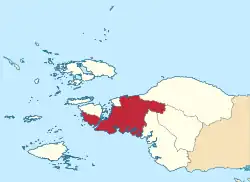 Location in Southwest Papua | |
 Sorong Regency Location in Indonesia | |
| Coordinates: 0°52′59″S 131°15′00″E / 0.88306°S 131.25000°E | |
| Country | Indonesia |
| Province | Southwest Papua |
| Capital | Aimas |
| Government | |
| • Regent | Vacant |
| • Vice Regent | Vacant |
| Area | |
| • Total | 13,075.28 km2 (5,048.39 sq mi) |
| Population (mid 2022 estimate)[1] | |
| • Total | 125,949 |
| • Density | 9.6/km2 (25/sq mi) |
| Time zone | UTC+9 (Indonesia Eastern Time) |
| Area code | (+62) 951 |
| Website | sorongkab |
Sorong Regency (Indonesian: Kabupaten Sorong) is a regency of Southwest Papua province of Indonesia.[2] It covers an area of 13,075.28 km2, and had a population of 70,619 at the 2010 Census,[3] and 118,679 at the 2020 Census;[4] the official estimate as at mid 2022 was 125,949.[1] Its administrative centre is the town of Aimas. Sorong Regency surrounds Sorong City (Kota) on the landward side; the city is administratively independent of the Regency and is not included in the above statistics; Sorong City has an airport, Sorong Airport, which also serves the Regency.
Geography
Sorong Regency is one of the regencies which is administratively included in the territory of the new Southwest Papua Province. Sorong Regency is located at 00° 33' 42” - 01° 35' 29" South Latitude and 130° 40' 49" - 132° 13' 48” East Longitude.[5]
Administrative Districts
At the time of the 2010 Census, the Sorong Regency was divided into eighteen administrative districts (distrik). However, since 2013 Moraid District has been transferred to the expanded Tambrauw Regency, while thirteen additional districts have been created in Sorong Regency by the division of existing districts. Thus Sorong Regency now comprises thirty districts (kecamatan), tabulated below with their populations at the 2010 Census[3] and 2020 census,[4] together with the official estimates as at mid 2022.[1]
The table also includes the locations of the district administrative centres, the number of administrative villages in each district (totaling 231 rural kampung and 26 urban kelurahan), and its post code.
| Kode Kememdagri | Name of District (distrik) | Area in km2 | Pop'n Census 2010 | Pop'n Census 2020 | Pop'n Estimate mid 2022 | Admin centre | No. of villages | Post code |
|---|---|---|---|---|---|---|---|---|
| 92.01.41 | Klaso | 345.03 | 306 | 574 | 606 | Siwis | 7 | 98456 |
| 92.01.48 | Saengkeduk | 395.74 | (a) | 537 | 567 | Suye | 6 | 98458 |
| 92.01.01 | Makbon | 690.06 | 2,130 | 3,200 | 3,294 | Makbon | 15 (b) | 98452 |
| 92.01.40 | Klayili | 394.32 | 416 | 1,147 | 1,212 | Klayili | 8 | 98451 |
| 92.01.04 | Beraur | 540.77 | 1,007 | 882 | 898 | Wanurian | 13 | 98432 |
| 92.01.44 | Bagun | 443.61 | (a) | 427 | 434 | Disfra | 9 | 98431 |
| 92.01.54 | Botain | 349.74 | (a) | 119 | 121 | Mamsit | 4 | 98433 |
| 92.01.08 | Klamono | 488.45 | 4,483 | 5,625 | 5,943 | Klawana | 10 | 98441 |
| 92.01.51 | Klasafet | 246.45 | (a) | 986 | 1,041 | Maladuk | 5 | 98442 |
| 92.01.49 | Malabotom | 443.61 | (a) | 1,085 | 1,146 | Tanah Tinggi | 9 | 98443 |
| 92.01.17 | Klabot | 394.32 | 638 | 595 | 646 | Klabot | 8 | 98436 |
| 92.01.47 | Buk | 345.03 | (a) | 665 | 722 | Buk | 7 | 98434 |
| 92.01.18 | Klawak | 591.48 | 597 | 791 | 836 | Wilty | 12 | 98437 |
| 92.01.50 | Konhir | 394.32 | (a) | 560 | 592 | Tarsa | 8 | 98438 |
| 92.01.52 | Hobard | 345.03 | (a) | 351 | 371 | Hobard | 7 | 98435 |
| 92.01.05 | Salawati | 345.03 | 9,149 | 12,091 | 12,774 | Katinim | 7 (c) | 98423 |
| 92.01.13 | Mayamuk | 541.19 | 9,983 | 14,321 | 14,613 | Makbalim | 11 (d) | 98421 |
| 92.01.42 | Moisegen (East Salawati) | 443.61 | 1,952 | 3,581 | 3,783 | Klafdalim | 9 | 98422 |
| 92.01.06 | Seget | 443.61 | 3,087 | 4,233 | 4,282 | Seget | 9 | 98426 |
| 92.01.12 | Segun | 443.61 | 1,369 | 1,634 | 1,609 | Segun | 9 | 98427 |
| 92.01.14 | Salawati Selatan (e) (South Salawati) | 295.74 | 2,057 | 1,212 | 1,219 | Sailolof | 6 | 98424 |
| 92.01.53 | Salawati Tengah (e) (Central Salawati) | 492.90 | (a) | 1,529 | 1,538 | Waliam | 10 | 98425 |
| 92.01.07 | Aimas | 690.06 | 19,911 | 42,014 | 46,195 | Aimas | 14 (f) | 98444 |
| 92.01.39 | Mariat | 542.19 | 10,432 | 16,735 | 17,449 | Mariat | 11(g) | 98445 |
| 92.01.43 | Sorong (district) | 443.61 | (a) | 785 | 829 | Maibo | 9 | 98446 |
| 92.01.10 | Sayosa | 398.19 | 988 | 1,020 | 1,078 | Sayosa | 6 | 98453 |
| 92.01.45 | Wemak | 395.74 | (a) | 725 | 776 | Saluk | 6 | 98455 |
| 92.01.55 | Sayosa Timur (East Sayosa) | 395.74 | (a) | 406 | 449 | Sailala | 6 | 98454 |
| 92.01.20 | Maudus | 443.61 | (a) | 467 | 515 | Luwelala | 9 | 98457 |
| 92.01.46 | Sunook | 347.04 | (a) | 382 | 412 | Dasri | 7 | 98459 |
| Totals | 13,075.28 | 68,902 | 118,679 | 125,949 | Aimas | 257 | ||
While the areas given above for the districts are exactly as given in BPS official statistics, they are highly questionable (note the repetition of certain values).
Notes: (a) the 2010 population of the new districts are included with the figures for the districts from which they were separated.
(b) includes 1 kelurahan (Makbon - the district centre).
(c) comprises 4 kelurahan (Katinim, Mararan, Majener, and Matawolat) and 3 kampung. (d) comprises 3 kelurahan (Makbalim, Makbosun, and Mayamuk) and 8 kampung.
(e) Salawati Selatan District and Salawati Tengah District are situated on the island of Salawati and are thus geographically part of the Raja Ampat island group.
(Conversely, Salamati District and Salawati Timur District - the latter now called Moisegen district - do not lie on Salawati Island, but on the Papuan 'mainland'.)
Note particularly that Raja Ampat Regency also contains a district on Salawati Island which is also named "Salawati Tengah".
(f) comprises 11 kelurahan (Aimas, Klabinain, Klafma, Klaigit, Malagusa, Malasom, Malawele, Malawili, Mariat Gunung, Mariat Pantai, and Warmon) and 3 kampung.
(g) comprises 7 kelurahan (Jamaimo, Klamalu, Klamasen, Klaru, Klasukuk, Maklalut, and Mariyai) and 4 kampung.
Climate
Aimas, the seat of the regency has a tropical rainforest climate (Af) with heavy to very heavy rainfall year-round. Unlike most parts of Indonesia, it experiences a rainfall maximum during the low-sun season due to local wind currents.
| Climate data for Aimas | |||||||||||||
|---|---|---|---|---|---|---|---|---|---|---|---|---|---|
| Month | Jan | Feb | Mar | Apr | May | Jun | Jul | Aug | Sep | Oct | Nov | Dec | Year |
| Mean daily maximum °C (°F) | 30.6 (87.1) |
30.5 (86.9) |
30.5 (86.9) |
30.6 (87.1) |
30.5 (86.9) |
29.9 (85.8) |
29.3 (84.7) |
29.3 (84.7) |
29.8 (85.6) |
30.6 (87.1) |
30.9 (87.6) |
30.7 (87.3) |
30.3 (86.5) |
| Daily mean °C (°F) | 27.4 (81.3) |
27.3 (81.1) |
27.4 (81.3) |
27.4 (81.3) |
27.4 (81.3) |
27.0 (80.6) |
26.5 (79.7) |
26.4 (79.5) |
26.8 (80.2) |
27.3 (81.1) |
27.6 (81.7) |
27.6 (81.7) |
27.2 (80.9) |
| Mean daily minimum °C (°F) | 24.2 (75.6) |
24.1 (75.4) |
24.4 (75.9) |
24.2 (75.6) |
24.3 (75.7) |
24.1 (75.4) |
23.7 (74.7) |
23.6 (74.5) |
23.8 (74.8) |
24.0 (75.2) |
24.3 (75.7) |
24.3 (75.7) |
24.1 (75.4) |
| Average rainfall mm (inches) | 215 (8.5) |
205 (8.1) |
223 (8.8) |
258 (10.2) |
392 (15.4) |
390 (15.4) |
348 (13.7) |
317 (12.5) |
272 (10.7) |
233 (9.2) |
201 (7.9) |
205 (8.1) |
3,259 (128.5) |
| Source: Climate-Data.org[6] | |||||||||||||
References
- 1 2 3 Badan Pusat Statistik, Jakarta, 2023, Kabupaten Sorong Dalam Angka 2023 (Katalog-BPS 1102001.9201)
- ↑ http://www.petra.ac.id/eastern/irian/cities/sorong/sorong.html%5B%5D
- 1 2 Biro Pusat Statistik, Jakarta, 2011.
- 1 2 Badan Pusat Statistik, Jakarta, 2021.
- ↑ Direktorat Jendral Cipta Karya Kementerian Pekerjaan Umum dan Perumahan Rakyat, Jakarta, 2021
- ↑ "Climate: Aimas". Climate-Data.org. Retrieved 24 November 2020.
External links
Regencies and cities of Southwest Papua | ||
|---|---|---|
Capital: Sorong | ||
| Regencies | ||
| Cities | ||