Mereto di Tomba
| |
|---|---|
| Comune di Mereto di Tomba | |
 Coat of arms | |
Location of Mereto di Tomba | |
 Mereto di Tomba Location of Mereto di Tomba in Italy 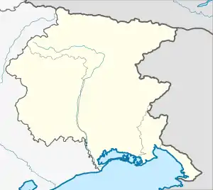 Mereto di Tomba Mereto di Tomba (Friuli-Venezia Giulia) | |
| Coordinates: 46°3′N 13°2′E / 46.050°N 13.033°E | |
| Country | Italy |
| Region | Friuli Venezia Giulia |
| Province | Udine (UD) |
| Frazioni | Pantianicco, Plasencis, Tomba, San Marco, Savalons |
| Government | |
| • Mayor | Claudio Violino |
| Area | |
| • Total | 27.40 km2 (10.58 sq mi) |
| Elevation | 98 m (322 ft) |
| Population | |
| • Total | 2,734 |
| • Density | 100/km2 (260/sq mi) |
| Demonym | Meretani |
| Time zone | UTC+1 (CET) |
| • Summer (DST) | UTC+2 (CEST) |
| Postal code | 33036 |
| Dialing code | 0432 |
| Website | Official website |
Mereto di Tomba (Friulian: Merêt di Tombe) is a comune (municipality) in the Regional decentralization entity of Udine in the Italian region of Friuli Venezia Giulia, located about 80 kilometres (50 mi) northwest of Trieste and about 15 kilometres (9 mi) west of Udine.
Mereto di Tomba borders the following municipalities: Basiliano, Codroipo, Coseano, Fagagna, San Vito di Fagagna, Sedegliano and Pasian di Prato.
Twin towns
Mereto di Tomba is twinned with:
 Oppeano, Italy
References
- ↑ "Superficie di Comuni Province e Regioni italiane al 9 ottobre 2011". Italian National Institute of Statistics. Retrieved 16 March 2019.
- ↑ Data from Istat
- ↑ "Popolazione Residente al 1° Gennaio 2018". Italian National Institute of Statistics. Retrieved 16 March 2019.
46°3′N 13°2′E / 46.050°N 13.033°E

This article is issued from Wikipedia. The text is licensed under Creative Commons - Attribution - Sharealike. Additional terms may apply for the media files.