Mortegliano
| |
|---|---|
| Comune di Mortegliano | |
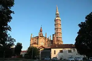 Mortegliano Cathedral | |
Location of Mortegliano | |
 Mortegliano Location of Mortegliano in Italy 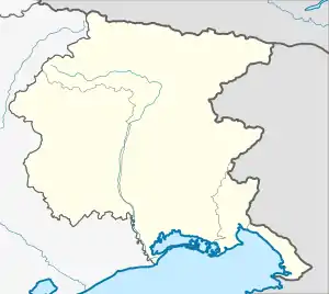 Mortegliano Mortegliano (Friuli-Venezia Giulia) | |
| Coordinates: 45°57′N 13°10′E / 45.950°N 13.167°E | |
| Country | Italy |
| Region | Friuli Venezia Giulia |
| Province | Udine (UD) |
| Frazioni | Chiasiellis, Lavariano |
| Government | |
| • Mayor | Roberto Zuliani |
| Area | |
| • Total | 30.05 km2 (11.60 sq mi) |
| Elevation | 41 m (135 ft) |
| Population (30 April 2017)[2] | |
| • Total | 4,967 |
| • Density | 170/km2 (430/sq mi) |
| Demonym | Morteglianesi |
| Time zone | UTC+1 (CET) |
| • Summer (DST) | UTC+2 (CEST) |
| Postal code | 33050 |
| Dialing code | 0432 |
| Website | Official website |
Mortegliano (Friulian: Mortean) is a comune (municipality) in the Regional decentralization entity of Udine in the Italian region of Friuli Venezia Giulia, located about 60 km northwest of Trieste and about 14 km southwest of Udine.
Mortegliano borders the following municipalities: Bicinicco, Castions di Strada, Lestizza, Pavia di Udine, Pozzuolo del Friuli, Talmassons.
The tallest campanile, or free-standing bell tower, in the world at 113.2 metres (371 ft) high, is the Mortegliano Bell Tower.[3][4]
Twin towns
Mortegliano is twinned with:
 Arborea, Italy
References
- ↑ "Superficie di Comuni Province e Regioni italiane al 9 ottobre 2011". Italian National Institute of Statistics. Retrieved 16 March 2019.
- ↑ All demographics and other statistics: Italian statistical institute Istat.
- ↑ "25 tallest clock towers/government structures/palaces" (PDF). Council on Tall Buildings and Urban Habitat. January 2008. Archived from the original (PDF) on 2008-10-30. Retrieved 2008-08-09.
- ↑ "Campus tour booklet" (PDF). University of Birmingham. Retrieved 2008-08-09.
External links

This article is issued from Wikipedia. The text is licensed under Creative Commons - Attribution - Sharealike. Additional terms may apply for the media files.