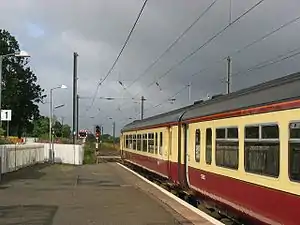
 Class 156 diesel train at Kirknewton | |
| General information | |
| Location | Kirknewton, West Lothian Scotland |
| Coordinates | 55°53′20″N 3°26′00″W / 55.8890°N 3.4332°W |
| Grid reference | NT104671 |
| Managed by | ScotRail |
| Platforms | 2 |
| Other information | |
| Station code | KKN |
| History | |
| Pre-grouping | Caledonian Railway |
| Post-grouping | LMS |
| Key dates | |
| 15 February 1848 | Opened as Kirknewton |
| April 1848 | Renamed Midcalder and Kirknewton |
| c. 1855 | Renamed Midcalder |
| 17 May 1982 | Renamed Kirknewton |
| Passengers | |
| 2018/19 | |
| 2019/20 | |
| 2020/21 | |
| 2021/22 | |
| 2022/23 | |
| Notes | |
Passenger statistics from the Office of Rail and Road | |
Kirknewton railway station is a railway station serving the village of Kirknewton in West Lothian, Scotland, Opened as Kirknewton in February 1848, the station was renamed Midcalder and Kirknewton after two months, before becoming Midcalder in 1855. The full circle was finally completed 127 years later in May 1982 when the name reverted to Kirknewton.[2] This was to distinguish it from Kirknewton station near Mindrum on the NER Cornhill Branch.[3]
The station lies on the Edinburgh branch of the West Coast Main Line, although it is not served by main line express services - it is served by commuter services on the Shotts Line from Glasgow Central to Edinburgh Waverley via Shotts. It is managed by ScotRail.
As there is no footbridge on the station (the footbridge was removed prior to electrification), passengers wishing to cross the line must do so via the level crossing, which is one of the most incorrectly used in Scotland.[4] There are plans to provide a new crossing (subway) which will remove the level crossing.[5] The level crossing is automatic and approach controlled which means trains which call at the station towards Glasgow have to stop so the driver can turn on the level crossing, This is done to allow traffic to cross when the train is stopped in the station.
History
Kirknewton was the terminus of the Slateford–Balerno line. A bay platform can still be seen to the east of the Edinburgh bound platform. The trains ran alongside the Water of Leith for 65 years, the line finally being closed to passengers on 30 October 1943. Goods trains continued to run until the line was officially closed, aided by the closure of the Kinleith Mill in 1966, to all traffic on 4 December 1967.
Services
As of May 2016 the station is served on Mondays to Saturdays by an hourly ScotRail stopping service between Glasgow Central and Edinburgh Waverley. There is a limited Sunday service to Edinburgh and Glasgow of just six trains each way.[6] One service on this route originates at Motherwell in the morning, returning there in the evening.[7]
There is a limited service to/from North Berwick each day (except Sundays) and to Ayr via Carstairs, Glasgow Central and Kilwinning. This is operated by a Class 380 EMU.
As this station is on the Edinburgh branch of the West Coast Main Line; a variety of Avanti West Coast, CrossCountry, London North Eastern Railway and TransPennine Express trains pass through without stopping.
| Preceding station | Following station | |||
|---|---|---|---|---|
| Curriehill | ScotRail Shotts Line |
Livingston South | ||
| Curriehill | ScotRail North Berwick Line |
Carstairs | ||
| Historical railways | ||||
| Connection at Midcalder Junction |
Caledonian Railway Cleland and Midcalder Line |
Newpark | ||
| Ravelrig Halt | Caledonian Railway Main Line |
Harburn | ||
References
Notes
- ↑ Brailsford 2017, Gaelic/English Station Index.
- ↑ Butt 1995, p. 159.
- ↑ Shaw, Donald (1989). The Balerno Branch and the caley in Edinburgh. Oakwood Library. p. 224. ISBN 978-0-85361-366-4.
- ↑ "Safety plea at level crossing". BBC News. 14 January 2003. Retrieved 17 August 2008.
- ↑ "£6M PLAN WILL END CROSSING DANGER". 31 August 2007. Retrieved 17 August 2008.
- ↑ Table 225 National Rail timetable, December 2012
- ↑ Table 224 National Rail timetable, May 2016
Sources
- Brailsford, Martyn, ed. (December 2017) [1987]. Railway Track Diagrams 1: Scotland & Isle of Man (6th ed.). Frome: Trackmaps. ISBN 978-0-9549866-9-8.
- Butt, R. V. J. (October 1995). The Directory of Railway Stations: details every public and private passenger station, halt, platform and stopping place, past and present (1st ed.). Sparkford: Patrick Stephens Ltd. ISBN 978-1-85260-508-7. OCLC 60251199. OL 11956311M.
- Jowett, Alan (March 1989). Jowett's Railway Atlas of Great Britain and Ireland: From Pre-Grouping to the Present Day (1st ed.). Sparkford: Patrick Stephens Ltd. ISBN 978-1-85260-086-0. OCLC 22311137.