Midori
みどり市 | |
|---|---|
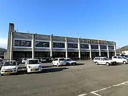
 Midori city hall | |
 Flag  Seal | |
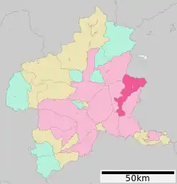
 Location of Midori in Gunma Prefecture | |
 Midori | |
| Coordinates: 36°23′41.3″N 139°16′52.1″E / 36.394806°N 139.281139°E | |
| Country | Japan |
| Region | Kantō |
| Prefecture | Gunma |
| Area | |
| • Total | 208.42 km2 (80.47 sq mi) |
| Population (August 31, 2020) | |
| • Total | 50,266 |
| • Density | 240/km2 (620/sq mi) |
| Time zone | UTC+9 (Japan Standard Time) |
| - Tree | Yoshino sakura |
| - Flower | Erythronium japonicum; Chrysanthemum |
| - Bird | Green pheasant |
| Phone number | 0277-76-2111 |
| Address | 2952 Shika, Kasakake-machi, Midori-shi, Gunma-ken 379-2395 |
| Website | Official website |

Midori (みどり市, Midori-shi) is a city located in Gunma Prefecture, Japan. As of 31 August 2020, the city had an estimated population of 50,266 in 21,028 households,[1] and a population density of 240 persons per km². The total area of the city is 208.42 square kilometres (80.47 sq mi).
Geography
Midori is located in eastern Gunma Prefecture in the northern Kantō Plains. The city is shaped like an inverse triangle, bordered by Tochigi Prefecture to the north, and by the city of Kiryū to the east and west. The Watarase River runs through parts of Midori City.
Surrounding municipalities
Climate
Midori has a Humid continental climate (Köppen Cfa) characterized by warm summers and cold winters with heavy snowfall. The average annual temperature in Midori is 14.0 °C. The average annual rainfall is 1296 mm with September as the wettest month. The temperatures are highest on average in August, at around 26.3 °C, and lowest in January, at around 2.7 °C.[2]
Demographics
Per Japanese census data,[3] the population of Midori has recently plateaued after a long period of growth.
| Year | Pop. | ±% |
|---|---|---|
| 1960 | 33,442 | — |
| 1970 | 34,969 | +4.6% |
| 1980 | 44,064 | +26.0% |
| 1990 | 49,502 | +12.3% |
| 2000 | 51,266 | +3.6% |
| 2010 | 51,900 | +1.2% |
| 2020 | 49,648 | −4.3% |
History
The city of Midori was established on March 27, 2006, from the merger of the town of Ōmama (from Yamada District), the town of Kasakake (from Nitta District), and the village of Azuma (from Seta District). All three districts were dissolved as a result of this merger.
Government
Midori has a mayor-council form of government with a directly elected mayor and a unicameral city council of 18 members. Midori contributes one member to the Gunma Prefectural Assembly. In terms of national politics, the city is part of Gunma 1st district of the lower house of the Diet of Japan.
Economy
Midori is noted for its production of tomatoes and eggplants.
Education
Midori has seven public elementary schools and five public middle schools operated by the city government, and one public high school operated by the Gunma Prefectural Board of Education. The prefecture also operates one special education school for the handicapped. Kiryu University and its associated junior college are located in Midori.
- Elementary schools
- Kasakake Elementary School
- Kasakake Higashi Elementary School
- Kasakake Kita Elementary School
- Omama Higashi Elementary School
- Omama Minami Elementary School
- Omama Kita Elementary School
- Azuma Elementary School
- Middle schools
- Kasakake Middle School
- Kasakake Minami Middle School
- Omama Middle School
- Omama Higashi Middle School
- Azuma Middle School
- High schools
- Omama High School
- Universities
Transportation
Railway
Watarase Keikoku Railway – Watarase Keikoku Line
![]() Jōmō Electric Railway Company - Jōmō Line
Jōmō Electric Railway Company - Jōmō Line
![]() Tōbu Railway – Tōbu Kiryū Line
Tōbu Railway – Tōbu Kiryū Line
- Azami – (Shin-Kiryū – Aioi) – Akagi
Highway
Local attractions

Noted people
- Yui Ogura, voice actress, singer
References
- ↑ "Midori City official statistics" (in Japanese). Japan.
- ↑ Midori climate data
- ↑ Midori population statistics
- ↑ "岩宿遺跡" (in Japanese). Agency for Cultural Affairs.
External links
![]() Media related to Midori, Gunma at Wikimedia Commons
Media related to Midori, Gunma at Wikimedia Commons
- Official Website (in Japanese)